geo.wikisort.org - Mountains
Belukha Mountain (Russian: Белуха, lit. 'whitey'; Altai: Ӱч-Сӱмер, lit. 'three peaks'; Kazakh: Мұзтау Шыңы, lit. 'icemount peak'), located in the Katun Mountains, is the highest peak of the Altai Mountains in Russia and the highest of the system of the South Siberian Mountains.[2] It is part of the World Heritage Site entitled Golden Mountains of Altai.[3]
| Belukha Mountain | |
|---|---|
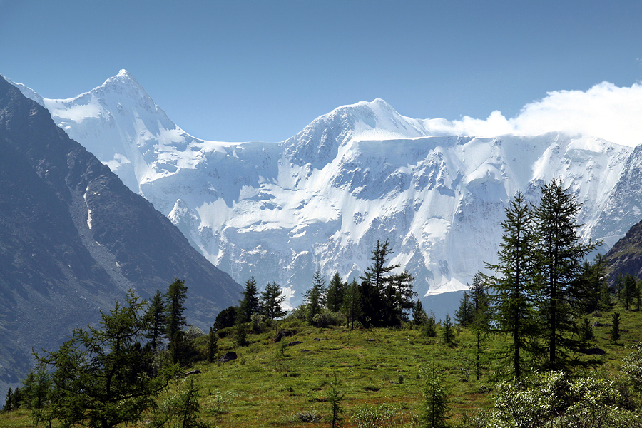 The top of Belukha in the Altai Mountains in Russia is shown here in 2006. The mountain range is thought to be the birthplace of the Turkic people. | |
| Highest point | |
| Elevation | 4,506 m (14,783 ft)[1] |
| Prominence | 3,343 m (10,968 ft)[1] Ranked 58th |
| Isolation | 668 km (415 mi) |
| Listing | Ultra |
| Coordinates | 49°48′27″N 86°35′24″E[1] |
| Geography | |
 Belukha Mountain Altai Republic, Russia  Belukha Mountain Belukha Mountain (Altai Republic)  Belukha Mountain Belukha Mountain (Kazakhstan) | |
| Parent range | Altai Mountains |
| Climbing | |
| First ascent | 1914 by B. V. Tronov & M. V. Tronov |
| Easiest route | basic rock/snow climb |
 | |
Since 2008, one is required to apply for a special border zone permit in order to be allowed into the area (if travelling independently without using an agency). Foreigners should apply for the permit to their regional FSB border guard office two months before the planned date.[4][5]
Geography
Located in the Altai Republic, Belukha is a three-peaked mountain massif that rises along the border of Russia and Kazakhstan, just a few dozen miles north of the point where this border meets with the border of China. There are several small glaciers on the mountain, including Belukha Glacier. Of the two peaks, the eastern peak (4,506 m, 14,784 ft.) is higher than the western peak (4,440 m, 14,567 ft.).
History
Belukha was first climbed in 1914 by the Tronov brothers. Most ascents of the eastern peak follow the same southern route as that taken in the first ascent. Though the Altai is lower in elevation than other Asian mountain groups, it is very remote, and much time and planning are required for its approach.
In the summer of 2001, a team of scientists traveled to the remote Belukha Glacier to assess the feasibility of extracting ice cores at the site. Research was carried out from 2001 to 2003: both shallow cores and cores to bedrock were extracted and analyzed (Olivier and others, 2003; Fujita and others, 2004). Based on tritium dating techniques, the deeper cores may contain as much as 3,000–5,000 years of climatic and environmental records. A Swiss-Russian team also studied the glacier.[6]
See also
- Highest points of Russian Federal subjects
- List of Altai mountains
- List of Ultras of Central Asia
- List of glaciers of Russia
 Siberia portal
References
![]() This article incorporates public domain material from websites or documents of the United States Geological Survey.
This article incorporates public domain material from websites or documents of the United States Geological Survey.
- "The Central Asian Republics Ultra Prominence Page" Listed as "Gora Belukha" on Peaklist.org. Retrieved 2011-11-20.
- "Mount Belukha". Encyclopædia Britannica. Retrieved 31 July 2007.
- "Golden Mountains of Altai". UNESCO. Archived from the original on 18 August 2007. Retrieved 31 July 2007.
- "Thorn Tree - New border zone regulation/ Altai concern". Lonely Planet.
- "dont you ever mind :: the great outdoors :: altai, russia, 2008". dontmind.freeshell.org. Archived from the original on 3 March 2016. Retrieved 8 May 2009.
- L. DeWayne Cecil; David L. Naftz; Paul F. Schuster; David D. Susong & Jaromy R. Green. "Glaciers of Asia— THE PALEOENVIRONMENTAL RECORD PRESERVED IN MIDDLE LATITUDE, HIGH-MOUNTAIN GLACIERS—AN OVERVIEW OF THE U.S. GEOLOGICAL SURVEY EXPERIENCE IN CENTRAL ASIA AND THE UNITED STATES" (PDF). US Geological Survey (public domain). Retrieved 13 May 2012.
External links
На других языках
[de] Belucha
Belucha (russisch Белуха von bely für „Weiß“; kasachisch Мұзтау шыңы Muztaý shyńy), auch Utsch-Sumer (altaisch Уч-Сумер Uč-Sumer für „die/der Dreiköpfige“) sowie Kadyn-Baschy (altaisch Кадын-Бажы Kadyn-Bažy für „Gipfel des Katun“), ist mit 4506 m der höchste Berg Sibiriens im engeren Sinne. Er liegt im zentralasiatischen Altaigebirge an der russisch-kasachischen Grenze unweit des Vierländerecks zwischen Russland, Kasachstan, Mongolei und China.- [en] Belukha Mountain
[es] Beluja
El monte Beluja (en su transcripción al inglés, Belukha) o Muztau (en ruso, Белуха), de 4506 m, es la cumbre más alta del macizo de Altái. Además, forma parte del Patrimonio de la Humanidad llamado Montañas Doradas de Altái.[fr] Mont Béloukha
Le mont Béloukha (en russe : Белуха, en altaï : Muztau), situé dans les monts Katoun, est le sommet le plus élevé de l'Altaï à la frontière entre le Kazakhstan et la Russie. Il est également le second plus haut sommet de la Sibérie[3] derrière le Klioutchevskoï (dans le Kamtchatka).[it] Belucha
Il monte Belucha (in russo: Белуха?; in kazako: Мұзтау?, traslitterato: Mustaý; in altaico: Ӱч-Сӱмер; lett. "tre teste") è la vetta più alta dei monti Katunskij, una catena degli Altaj. Si trova nell'Ust'-Koksinskij rajon della Repubblica dell'Altaj, in Russia, al confine con il Kazakistan.[ru] Белуха (гора)
Белу́ха (алт. Ӱч-Сӱмер — «Трёхглавая», Кадын-Бажы — «Вершина Катуни», каз. Мұзтау Шыңы[4][5]) — высшая точка Алтайских гор (4506 м), одна из высочайших горных вершин России[6]. Венчает Катунский хребет.Другой контент может иметь иную лицензию. Перед использованием материалов сайта WikiSort.org внимательно изучите правила лицензирования конкретных элементов наполнения сайта.
WikiSort.org - проект по пересортировке и дополнению контента Википедии