geo.wikisort.org - River
The Franconian Rezat (German: Fränkische Rezat) is a 77-kilometre-long (48 mi) river in southern Germany.[4] It is the western, left source river of the Rednitz.[5] It rises in the Franconian Heights near Oberdachstetten. It flows generally east through the towns Lehrberg, Ansbach, Windsbach and Spalt. Together with the Swabian Rezat (Schwäbische Rezat), it forms the Rednitz in Georgensgmünd.
| Franconian Rezat | |
|---|---|
 The Franconian Rezat near Windsbach | |
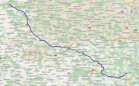 Course of the Franconian Rezat | |
| Location | |
| Country | Germany |
| State | Bavaria |
| Region | Middle Franconia |
| Reference no. | DE: 242 |
| Physical characteristics | |
| Source | |
| • location | On the Franconian Heights northwest of Oberdachstetten |
| • coordinates | 49°25′39″N 10°23′47″E |
| • elevation | 452 m above sea level (NN) [1] |
| Mouth | |
• location | Confluence: with the Swabian Rezat in Georgensgmünd to form the Rednitz |
• coordinates | 49°11′17″N 11°01′20″E |
• elevation | 342 m above sea level (NN) |
| Length | 77.3 km (48.0 mi) [2] |
| Basin size | 456 km2 (176 sq mi) [2] |
| Discharge | |
| • location | at Ansbach (26.3 % of the catchment) gauge[3] |
| • average | 744 l/s (9,820 imp gal/min) |
| • minimum | Record low: 20 l/s (260 imp gal/min) Average low: 158 l/s (2,090 imp gal/min) |
| • maximum | Average high: 19.9 m3/s (700 cu ft/s) Record high: 60.0 m3/s (2,120 cu ft/s) (in 1941) |
| Basin features | |
| Progression | Rednitz→ Regnitz→ Main→ Rhine→ North Sea |
 The Markgrafen Bridge at Windsbach
 The Franconian Rezat near Wassermungenau
 The Franconian Rezat near Georgensgmünd | |
See also
References
- TOP 10 Bayern Nord
- Complete table of the Bavarian Waterbody Register by the Bavarian State Office for the Environment (xls, 10.3 MB)
- Bayerischer Hochwassernachrichtendienst Archived 2011-05-11 at the Wayback Machine (as at: 6 September 2011)
- Baedeker (Firm), Karl (1907). Southern Germany (Wurtemberg and Bavaria): Handbook for Travellers. K. Baedeker. p. 109.
Franconian Rezat, southern germany.
- "Rednitz - River". RouteYou. Retrieved 2019-11-27.
| Authority control |
|
|---|
На других языках
[de] Fränkische Rezat
Die Fränkische Rezat in Mittelfranken ist mit einem Einzugsgebiet von 456 km² und 77,3 km[2] Länge der bedeutendere Quellfluss der Rednitz. Sie vereinigt sich von links und Westen kommend mit der Schwäbischen Rezat zur Rednitz, dem Hauptquellfluss der Regnitz. Diese ist wiederum an ihrer Mündung in den Main merklich wasserreicher als der aufnehmende Fluss, weshalb der hydrologische Hauptstrang des Main-Systems mit der Fränkischen Rezat beginnt.- [en] Franconian Rezat
[it] Rezat Francone
Il Rezat Francone è un fiume tedesco lungo 63,5 km; assieme al Rezat Svevo forma il fiume Rednitz nella Media Franconia.[ru] Френкише-Рецат
Френкише-Рецат (нем. Fränkische Rezat) — река в Германии, протекает по Средней Франконии (земля Бавария). Речной индекс 24211[1]. Площадь бассейна реки составляет 456,00 км²[1]. Длина реки — 77,25 км[1]. Высота истока 452 м[2]. Высота устья 342 м[3].Текст в блоке "Читать" взят с сайта "Википедия" и доступен по лицензии Creative Commons Attribution-ShareAlike; в отдельных случаях могут действовать дополнительные условия.
Другой контент может иметь иную лицензию. Перед использованием материалов сайта WikiSort.org внимательно изучите правила лицензирования конкретных элементов наполнения сайта.
Другой контент может иметь иную лицензию. Перед использованием материалов сайта WikiSort.org внимательно изучите правила лицензирования конкретных элементов наполнения сайта.
2019-2026
WikiSort.org - проект по пересортировке и дополнению контента Википедии
WikiSort.org - проект по пересортировке и дополнению контента Википедии