geo.wikisort.org - River
The Fossa Carolina (or Karlsgraben in German) was a canal named after Charlemagne in what is today the German state of Bavaria, intended to connect the Swabian Rezat river to the Altmühl river (the Rhine basin to the Danube basin). It was created during the early Middle Ages, long before the Ludwig Canal and the Rhine-Main-Danube Canal. If it was indeed operational, this canal would have been the first to link the Rhine basin to the Danube basin, across the European Watershed. However, contemporary sources are contradictory as to whether it was ever finished or not.
This article needs additional citations for verification. (November 2016) |

Geography
Near Treuchtlingen and Weißenburg in Bayern the European Watershed between the rivers of the Rhine basin and those of the Danube basin is very narrow. Only around 2 km of fairly level terrain lie between the Swabian Rezat and the Altmühl.[1]
History
Carolingian sources report that Frankish king Charlemagne gave orders to dig a 2 kilometers long canal from Treuchtlingen to Weißenburg in Bayern in 793. According to Einhard, writing around two decades later, Charlemagne was convinced by "supposed experts" that it would be possible to travel in comfort by ship from Rhine to Danube if the Rezat could be linked to the Altmühl. The king assembled a large number of workers and in person supervised construction in the fall of 793 of a 2,000 step long and 300 feet wide moat. Einhard reports that the project failed due to the marshy ground and continuous rainfall, which caused excavated material to slide back.[1]
But other sources indicate that it was in fact completed and fully operational.[2] The canal may have worked with several ponds, dikes and dams.[2]
It seems that the goal of this work was to improve the transportation of goods between the Rhineland and Bavaria. Another theory claims that the main purpose was to bring back Charlemagne's war vessels from the Danube to the Rhine.
In the 19th century, the project inspired king Ludwig I of Bavaria to build the Ludwig Canal, which opened in 1846.[1]
Research
Research by Robert Koch in 1992/3 showed that the floor of the canal was not level, but followed a step-like profile, rising from the direction of the Altmühl towards the north. Koch argued that the canal could have been flooded by damming the Rezat at Dettenheim and that the project could quite possibly have been finished. Geoarcheological work in 2009, however, showed that what had been considered an early medieval dam at Dettenheim was likely only built in the late Middle Ages and did not in fact serve to dam the Rezat.[1]
A DFG research project at the site, started in 2012, is still ongoing. It is part of a project "Ports from Imperial Roman times to the early Middle Ages" and looks at what the original canal may have looked like - and if there are any indications of whether it ever actually linked the two rivers.[3]
Today
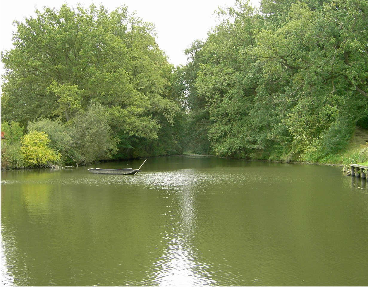
Today, only a 500 meter long part of the canal still exists as a water-filled moat. It lies in the municipality of Treuchtlingen in the Ortsteil known as Graben. The heaps of dug out earth that make up the banks stretch further, totalling around 1,200 m, rising to up to 10 meters in height. To the north a dry section of around 700 meters follows which is still visible in the terrain but has been almost completely leveled.[1]
References
- Berg-Hobohm, Stefanie; et al. (February 2014). "Fossa Carolina - Karls Kanal". Archäologie in Deutschland (in German). WBG. pp. 32–5.
- Leitholdt, Eva; Zielhofer, Christoph; Berg-Hobohm, Stefanie; Schnabl, Katharina; Kopecky-Hermanns, Britta; Bussmann, Jens; Härtling, Joachim W.; Reicherter, Klaus; Unger, Katrin (2012). "Fossa Carolina: The First Attempt to Bridge the Central European Watershed—A Review, New Findings, and Geoarchaeological Challenges". Geoarchaeology. 27 (1): 88–104. doi:10.1002/gea.21386. ISSN 1520-6548.
- "Fossa Carolina". DFG. Retrieved 24 November 2016.
External links
| Wikimedia Commons has media related to Fossa Carolina. |
- Fossa Carolina (English)
- Ingolstadt und die Fossa Carolina Karls des Großen (German)
Further reading
- Berg-Hobohm, Stefanie, Kopecky-Herrmanns, Britta, Naturwissenschaftliche Untersuchungen in der Umgebung des Karlsgrabens (Fossa Carolina), In: Berichte der Bayerischen Bodendenkmalpflege, No. 52, 2012, p. 403-18.
- Koch, Robert, Fossa Carolina. Neue Erkenntnisse zum Schiffahrtskanal Karls des Großen. In: Elmshäuser, Konrad (ed.), Häfen, Schiffe, Wasserwege. Zur Schifffahrt des Mittelalters, Bremerhaven 2002, p. 54-70.
- Leitholdt, Eva, et al., Fossa Carolina. The first try to bridge the Central European Watershed - a review, new findings and geoarchaeological challenges, In: Geoarchaeology - an international journal, 27, p. 88-104. Available online at http://www.uni-leipzig.de/geographie/phygeo/files/2010/06/Leitholdt-Zielhofer-et-al.-2012.pdf
Authority control | |
|---|---|
| General |
|
| National libraries | |
На других языках
[de] Fossa Carolina
Die Fossa Carolina (auch der Karlsgraben genannt) war ein Kanalbauprojekt Karls des Großen, um für die Schiffe seiner Zeit eine befahrbare Verbindung zwischen dem Flusssystem des Rheins und dem der Donau herzustellen. Als geeignet zur Überquerung der Europäischen Hauptwasserscheide erwies sich eine Stelle zwischen der zum Flusssystem des Rheins gehörenden Schwäbischen Rezat und der zur Donau fließenden Altmühl, bei der sich beide Flüsse bis auf nur 1800 Meter annähern. Dort finden sich noch heute beeindruckende Kanalreste beim Ort Graben, einem Ortsteil von Treuchtlingen im mittelfränkischen Landkreis Weißenburg-Gunzenhausen. Während vor Jahren von Wissenschaftlern die Meinung vertreten wurde, dass der Kanal komplett schiffbar war, mehrten sich seit dem Beginn der archäologischen Untersuchungen im Jahre 2012 die Hinweise, dass die Bauarbeiten abgebrochen wurden und der Kanal nicht fertiggestellt wurde.[1][2]- [en] Fossa Carolina
[it] Fossa Carolina
La Fossa Carolina (in tedesco: Karlsgraben) era un progetto di costruzione di canali artificiali di Carlo Magno al fine di creare un collegamento navigabile tra i sistemi fluviali del Reno e del Danubio per le navi dell'epoca. Un luogo tra il Rezat svevo, che fa parte del sistema fluviale del Reno, e l'Altmühl, che sfocia nel Danubio, dove i due fiumi si avvicinano tra loro entro 1800 metri, si rilevò idoneo per l'attraversamento dello spartiacque principale europeo. Lì si possono ancora trovare imponenti resti di canali vicino al villaggio di Graben, un distretto di Treuchtlingen nel circondario di Weißenburg-Gunzenhausen nella Media Franconia. Mentre anni fa gli studiosi erano dell'opinione che il canale fosse completamente navigabile, dall'inizio delle indagini archeologiche nel 2012 ci sono sempre più prove che i lavori di costruzione furono annullati e il canale non fu completato[1][2].[ru] Карлсграбен
Карлсграбен (нем. Karlsgraben — канал Карла; лат. Fossa carolina) — фрагментарно сохранившийся судоходный канал каролингской эпохи, соединявший реки Швабский Рецат и Альтмюль в современной Баварии, между городами Вайсенбург и Тройхтлинген. Проложенный в 790-х годах по приказанию Карла Великого канал должен был соединить речные системы Рейна и Дуная, впадающих в Северное и Чёрное моря, и служил, вероятно, для облегчения торговли во франкском королевстве.Другой контент может иметь иную лицензию. Перед использованием материалов сайта WikiSort.org внимательно изучите правила лицензирования конкретных элементов наполнения сайта.
WikiSort.org - проект по пересортировке и дополнению контента Википедии