geo.wikisort.org - River
The Ludwig Canal (German: Ludwig-Donau-Main-Kanal or Ludwigskanal), is an abandoned canal in southern Germany.[1]


The canal linked the Danube River at Kelheim with the Main River at Bamberg, connecting the Danube basin with the Rhine basin. The first realisation of a dream to enable barges to navigate from the North Sea to the Black sea, the Ludwig Canal proved to be unsustainable, and was eventually succeeded by a larger canal, over a century later.[2][3]
Named after King Ludwig I of Bavaria, the canal was built between 1836 and 1846. Whereas the Main and the Danube were both broad canalised rivers, the Ludwig Canal was a narrow channel, with numerous locks, and a shortage of water supply to the summit level. The canal became a bottleneck, and the operation of the waterway soon became uneconomic. A further nail in the canal's coffin was competition from the rapidly developing railway network in the southern German countryside.[4] Rather than repair the damage suffered during World War II, (the canal being close to the bombed city of Nuremberg), the canal was finally abandoned in 1950.
Construction of the Ludwig Canal's replacement, the much larger Rhine–Main–Danube Canal, was started in 1921, but not completed until 1992. The new canal is shorter and follows a route to the south and west of the earlier canal.[5]
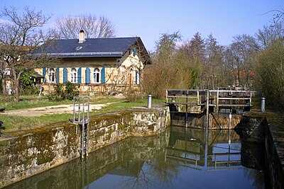
The remnants of the Ludwig Canal
Today, there still exists between Nuremberg and Berching some 60 km of canal in good condition. Some of the locks still function, and part of the towpath has been converted to a cycle track.[6] The old canal comes close to the new canal at Pollanten, and from there the two canals flow downstream in parallel, eventually meeting 5 km south of Berching.
References
External links
| Wikimedia Commons has media related to Ludwig Canal. |
- "Ludwig-Donau-Main-Kanal". Ludwig-Donau-Main-Kanal (in German). Retrieved 2020-07-03.
На других языках
[de] Ludwig-Donau-Main-Kanal
Der Ludwig-Donau-Main-Kanal (auch Ludwigskanal oder regional „Alter Kanal“ genannt) war im 19. und 20. Jahrhundert eine 172,4 km lange Wasserstraße zwischen der Donau bei Kelheim und dem Main bei Bamberg. Im weiteren Sinne war der zwischen 1836 und 1846 erbaute Kanal Teil einer schiffbaren Verbindung zwischen der Nordsee bei Rotterdam und dem Schwarzen Meer bei Constanța. Durch die Überquerung der Europäischen Hauptwasserscheide nahm das ehrgeizige Bauvorhaben eine besondere Stellung ein. 100 Schleusen, teilweise in den Flüssen Altmühl und Regnitz, bewältigten insgesamt einen Höhenunterschied von 264 Metern (80 m Aufstieg von der Donau und 184 m Abstieg zum Main). Nachfolger des 1950 aufgelassenen Kanals ist der 1960 bis 1992 errichtete Main-Donau-Kanal.- [en] Ludwig Canal
[ru] Людвигс-канал
Лю́двигс-кана́л[1], (также канал Лю́двига[2], нем. Ludwig-Donau-Main-Kanal или нем. Ludwigskanal) — неиспользуемый канал на юге Германии. Соединял Дунай в районе города Кельхайм с Майном в районе Бамберга. Построен между 1836 и 1845 годами[1], назван в честь баварского короля Людвига I. Длина канала — 172 километра[1].Другой контент может иметь иную лицензию. Перед использованием материалов сайта WikiSort.org внимательно изучите правила лицензирования конкретных элементов наполнения сайта.
WikiSort.org - проект по пересортировке и дополнению контента Википедии