geo.wikisort.org - River
Enoggera Creek is a creek which flows through the City of Brisbane in South-East Queensland, Australia.[1]
| Enoggera | |
|---|---|
 Enoggera Creek at The Gap, 2010 | |
| Location | |
| Country | Australia |
| State | Queensland |
| Region | South East Queensland |
| City | Brisbane |
| Physical characteristics | |
| Source | Enoggera Reservoir |
| • location | D'Aguilar Range |
| • coordinates | 27.4017°S 152.8059°E |
| Mouth | Breakfast Creek |
• location | railway bridge at the intersection of the suburbs of Windsor, Albion and Bowen Hills |
• coordinates | 27.4336°S 153.0397°E |
| Basin features | |
| Tributaries | |
| • right | Ithaca Creek |
Geography
Enoggera Creek rises in the suburb of Enoggera Reservoir on the D'Aguilar Range and flows into the Brisbane River (becoming Breakfast Creek in the final stage). The creek's headwaters form on the southern slopes of Mount Nebo in Brisbane Forest Park.
Within the suburb of Enoggera Reservoir, the creek is dammed by Enoggera Dam ( (27.4473°S 152.927°E). After which, it meanders in a south-easterly direction, leaving the undisturbed parkland and flowing through the Brisbane suburbs of The Gap, Ashgrove (where it separates the neighbourhood of St Johns Wood from the rest of the suburb), Alderley, Newmarket, Red Hill, Kelvin Grove, Wilston, Herston, Windsor and Bowen Hills.[2]
Ithaca Creek flows from Mount Coot-tha and joins Enoggera Creek from the south at the intersection of the suburbs of Ashgrove, Red Hill and Newmarket (27.4453°S 153.0019°E).[2][3]
The creek officially becomes Breakfast Creek from the railway bridge at the intersection of the suburbs of Windsor, Bowen Hills, and Albion, which then flows into the Brisbane River.[1]
The creek is being rehabilitated and restored by the community organisation called Save Our Waterways Now.[4]
History
Significant flooding occurred along the creek during the major floods, including 1893 and 1974 Brisbane flood resulting in a number of houses being washed away.[citation needed]
 Flooding around Enoggera Creek, Windsor, 1893
 Fishing and boating parties at Enoggera Creek, circa 1900
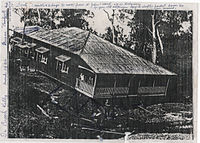 Relocating a house from St Johns Wood to Ashgrove, 1934


See also
- Kedron Brook
- List of rivers of Australia
- Moggill Creek
References
- "Enoggera Creek – watercourse in City of Brisbane (entry 11783)". Queensland Place Names. Queensland Government. Retrieved 4 July 2020.
- "Queensland Globe". State of Queensland. Retrieved 3 July 2020.
- "Ithaca Creek – watercourse in the City of Brisbane (entry 16888)". Queensland Place Names. Queensland Government. Retrieved 4 July 2020.
- Save Our Waterways Now: About Us
External links
![]() Media related to Enoggera Creek at Wikimedia Commons
Media related to Enoggera Creek at Wikimedia Commons
Другой контент может иметь иную лицензию. Перед использованием материалов сайта WikiSort.org внимательно изучите правила лицензирования конкретных элементов наполнения сайта.
WikiSort.org - проект по пересортировке и дополнению контента Википедии