geo.wikisort.org - River
The East Gallatin River flows 42 miles (68 km) in a northwesterly direction through the Gallatin valley, Gallatin County, Montana. Rising from the confluence of Rocky Creek and several other small streams, the East Gallatin begins about one mile (1.6 km) east of downtown Bozeman, Montana. The river joins the main stem of the Gallatin River 2.3 miles (3.7 km) north of Manhattan, Montana. Throughout its course, the river traverses mostly valley floor ranch and farm land with typical summer flows of approximately 50 cu ft/s (1.4 m3/s).[4]
| East Gallatin River | |
|---|---|
 East Gallatin River near Belgrade, Montana | |
 Location of mouth | |
| Location | |
| Country | United States |
| State | Montana |
| County | Gallatin |
| Physical characteristics | |
| Source | |
| • coordinates | 45°39′51″N 110°57′10″W |
| Mouth | |
• location | Nixon Gap |
• coordinates | 45°53′30″N 111°20′01″W[1] |
• elevation | 4,157 feet (1,267 m)[1] |
| Length | 42 miles (68 km) |
| Basin size | 148 square miles (380 km2)[2] (Gallatin Range, Bridger Range) |
| Discharge | |
| • location | Belgrade |
| • average | 137 cu/ft. per sec.[3] |
| Basin features | |
| River system | Missouri River |
Angling the East Gallatin
The East Gallatin river is a popular trout fishing stream and holds good populations of rainbow and brown trout as well as mountain whitefish. Access is limited to country road crossings and two public assess sites maintained by the Montana Fish, Wildlife and Parks department.[5] Numerous spring creeks, most notably Ben Hart and Thompson, feed the East Gallatin throughout its course and provide excellent trout fishing as well.
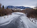 East Gallatin River near Bozeman, Montana in Winter
 Typical East Gallatin River rainbow trout (Released)
 Typical East Gallatin River brown trout (Released)
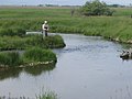 Ben Hart Spring Creek on the MZ Ranch near Belgrade, MT
 Thompson Spring Creek on the MZ Ranch near Belgrade, MT
 Kayak fishing on the East Gallatin
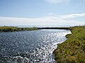 East Gallatin River near Swamp Road, September 2008
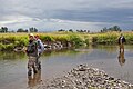 President Barack Obama and local fishing guide Dan Vermillion fish the East Gallatin River August 14, 2009


See also
- List of rivers of Montana
- Montana Stream Access Law
- Fly fishing
References
- Holt, John (1996). Montana Fly-Fishing Guide-East. Guilford, CT: The Lyons Press. ISBN 1-58574-529-4.
Notes
- "East Gallatin River". Geographic Names Information System. United States Geological Survey.
- "USGS Streamgage statistics-East Gallatin River". USGS. Retrieved 2012-06-18.
- "USGS Surface Water data for Montana: USGS Surface-Water Annual Statistics".
- USGS Montana Streamflow Data
- Montana Fish, Wildlife and Parks—E. Gallatin River
Helena (capital) | ||
| Topics |
|  Seal of Montana |
| Society |
| |
| Regions |
| |
| Largest cities | ||
| Counties |
| |
Другой контент может иметь иную лицензию. Перед использованием материалов сайта WikiSort.org внимательно изучите правила лицензирования конкретных элементов наполнения сайта.
WikiSort.org - проект по пересортировке и дополнению контента Википедии