geo.wikisort.org - River
The Doubs (French: [du] (![]() listen); Arpitan: Dubs; German: Dub) is a 453-kilometre (281 mi) river in far eastern France which strays into western Switzerland. It is a left-bank tributary of the Saône.[1] It rises near Mouthe in the western Jura mountains, at 946 metres (3,104 ft) and its mouth is at Verdun-sur-le-Doubs, a village and commune in Saône-et-Loire at about 175 m (574 ft) above sea level. It is the tenth-longest river in France.
listen); Arpitan: Dubs; German: Dub) is a 453-kilometre (281 mi) river in far eastern France which strays into western Switzerland. It is a left-bank tributary of the Saône.[1] It rises near Mouthe in the western Jura mountains, at 946 metres (3,104 ft) and its mouth is at Verdun-sur-le-Doubs, a village and commune in Saône-et-Loire at about 175 m (574 ft) above sea level. It is the tenth-longest river in France.
| Doubs | |
|---|---|
 The Doubs upstream of Besançon, amid richly-forested high hills | |
 | |
| Native name | Dubs (Arpitan) |
| Location | |
| Countries |
|
| Physical characteristics | |
| Source | |
| • location | Mouthe, Jura mountains |
| • coordinates | 46°42′17″N 6°12′34″E |
| • elevation | 946 m (3,104 ft) |
| Mouth | |
• location | Saône |
• coordinates | 46°54′3″N 5°1′27″E |
• elevation | 175 m (574 ft) |
| Length | 453 kilometres (281 mi) |
| Basin size | 7,500 km2 (2,900 sq mi) |
| Discharge | |
| • average | 176 m3/s (6,200 cu ft/s) |
| Basin features | |
| Progression | Saône→ Rhône→ Mediterranean Sea |
| Tributaries | |
| • left | Loue |
| • right | Allan |
| Lakes | Lac de Saint-Point, Lac des Brenets, Lac de Moron |
| gender (masculine: preceded by le/du) | |
The most populous settlement of the basin lies on its banks, Besançon. Its course includes a small waterfall and a 4-kilometre (2.5 mi) narrow lake.
Course
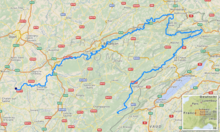
From its source in Mouthe it flows northeast: a few kilometers north of the French-Swiss border, then to form the border for less distance, about 40 km. North of the Swiss town of Saint-Ursanne it turns west then southwest. South-east of Montbéliard it adopts a southwest striation or fault of the Jura Mountains, flowing so over greater distance than the flow it has traced before. It then flows into the Saône at Verdun-sur-le-Doubs about 20 km (12 mi) northeast of Chalon-sur-Saône.
The shape of the course resembles the silhouette of a terrier sitting upright, leaning right, with the upper part of a northeastern corner "ear" the only zone in Switzerland, there reaching Saint-Ursanne. In that country it borders or crosses the cantons Jura and Neuchâtel.
Waterfalls and lake
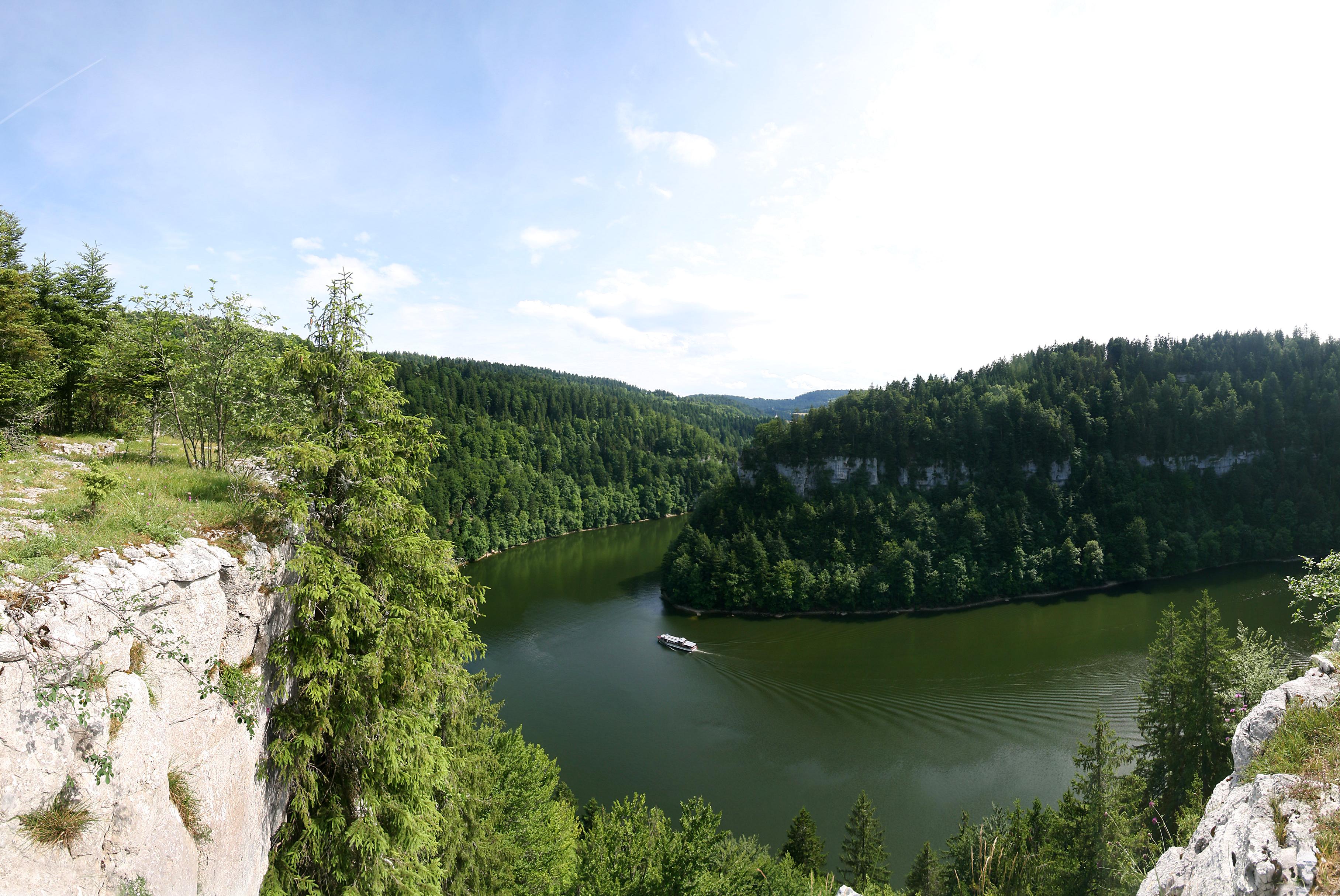
The falls known as the Saut du Doubs is on the French-Swiss border.
Nearby, the river, dammed up by landslide debris, forms the 4-kilometre (2.5 mi) long, 200-metre (660 ft) wide, winding lake, (le) Lac des Brenets. The 27-metre (89 ft)-high Doubs Falls are at the lake's end. The falls can be reached on foot or by passenger boat.[2]


The Doubs flows through the following Departments of France, Cantons of Switzerland, and cities:
- Doubs (F): Pontarlier
- Neuchâtel (CH)
- Jura (CH): Saint-Ursanne
- Doubs (F): Montbéliard, Besançon
- Jura (F): Dole
- Saône-et-Loire (F): Verdun-sur-le-Doubs
Tributaries include:[1]
The river forms several lakes:
- Lac de Saint-Point (elevation 850 m or 2,790 ft) near Pontarlier
- Lac des Brenets (elevation 750 metres or 2,460 feet)
- Lac de Moron (elevation 716 metres or 2,349 feet)
- Lac de Biaufond (elevation 610 metres or 2,000 feet)
Floods and seasonal variation
The rate of flow of the Doubs is very seasonally variable. The flooding or well-watered season can stretch from September to May, caused by heavy rains or by quick melting of snow from the Jura mountains. At its mouth, the discharge rate can vary from as low as 20 cubic metres per second (710 cu ft/s) to over 1,000 cubic metres per second (35,000 cu ft/s) during floods.
In Besançon, the largest floods have been in 1852 (8.5 metres or 27 feet 11 inches), in 1896 (7.96 metres or 26 feet 1 inch) and in 1910.
Hydroelectricity

As a mountain river with substantial discharge, the Doubs has been used for electricity generation. Among several hydroelectric stations, the most important are the Dam of Châtelot, 74 metres (243 ft) tall, and the Dam of Refrain, 66.5 metres (218 ft) tall.
In popular culture
The river is mentioned sixteen times in Stendhal's novel The Red and the Black (Le rouge et le noir).
See also
- Nature parks in Switzerland
- January 1910 Doubs river flood
References
Authority control | |
|---|---|
| General |
|
| National libraries | |
| Other | |
| Wikisource has the text of the 1911 Encyclopædia Britannica article "Doubs (river)". |
| Wikimedia Commons has media related to Doubs River. |
На других языках
[de] Doubs
Der Doubs .mw-parser-output .IPA a{text-decoration:none}[du] (deutsch antiquiert die Dub[4]) ist ein französisch-schweizerischer Fluss im Osten Frankreichs und im Nord-Westen der Schweiz. Er ist linker und größter Nebenfluss der Saône. In der Antike führte der Doubs, der im Gebiet der Sequaner lag, den Namen Dubis und wurde u. a. von Julius Caesar[5] und Strabon[6] erwähnt.- [en] Doubs (river)
[es] Río Doubs
El río Doubs (en francoprovenzal y en español áurico, Dubs) es un río de Francia y Suiza, un afluente del río Saona por la izquierda. Nace en Mouthe (departamento de Doubs), a 937 m sobre el nivel del mar, atraviesa el lago de Saint-Point, y forma la frontera franco-suiza durante decenas de kilómetros, antes de entrar en el cantón suizo del Jura, definiendo el llamado Clos du Doubs. En este punto cambia de dirección de SW-NE a ENE-WSW, regresando a Francia, para volver a girar, esta vez al S-N hasta llegar a la aglomeración de Montbéliard (no llega a la ciudad propiamente dicha). Allí toma curso NE-SW, pasando por Besançon —donde bordea la ciudad antigua— y Dole, para unirse al Saona en Verdun-sur-le-Doubs (Saona y Loira).[it] Doubs (fiume)
Il Doubs è un fiume lungo 453 km che scorre tra la Svizzera occidentale e la Francia orientale, tributario sinistro della Saona. La sua sorgente si trova presso Mouthe, nei Giura occidentali. Dapprima il corso del fiume segue la direzione nord-est, all'incirca lungo la frontiera franco-svizzera (che il fiume rappresenta per circa 40 km). Vicino a Montbéliard un'ansa porta la direzione del corso d'acqua verso sud-ovest, fino alla confluenza con la Saona a Verdun-sur-le-Doubs.[ru] Ду (приток Соны)
Ду (фр. Doubs) — река во Франции (Бургундия — Франш-Конте) и Швейцарии (Невшатель и Юра). Длина 453 км. Площадь водосборного бассейна — 7710 км².Другой контент может иметь иную лицензию. Перед использованием материалов сайта WikiSort.org внимательно изучите правила лицензирования конкретных элементов наполнения сайта.
WikiSort.org - проект по пересортировке и дополнению контента Википедии