geo.wikisort.org - River
The Aube (French pronunciation: [ob] (![]() listen)) is a river in France, a right tributary of the Seine. It is 248.9 kilometres (154.7 mi) long.[1] The river gives its name to the Aube department.
listen)) is a river in France, a right tributary of the Seine. It is 248.9 kilometres (154.7 mi) long.[1] The river gives its name to the Aube department.
| Aube | |
|---|---|
 Aube at Bar-sur-Aube | |
 | |
| Location | |
| Country | France |
| Physical characteristics | |
| Source | |
| • location | Champagne-Ardenne |
| • coordinates | 47°45′37″N 5°7′29″E |
| Mouth | |
• location | Seine |
• coordinates | 48°33′26″N 3°43′3″E |
| Length | 249 km (155 mi) |
| Basin size | 3,600 km2 (1,400 sq mi) |
| Discharge | |
| • average | 34 m3/s (1,200 cu ft/s) |
| Basin features | |
| Progression | Seine→ English Channel |
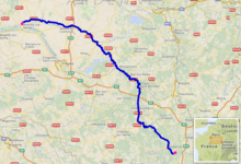
Its source is in the Haute-Marne department, on the plateau of Langres, near the town of Auberive. It flows through the departments of Haute-Marne, Côte-d'Or, Aube, and Marne. It flows into the river Seine near Marcilly-sur-Seine. Cities along the river include Bar-sur-Aube and Arcis-sur-Aube.
Main tributaries
- Aubette
- Aujon
- Landon
- Voire
- Ravet
- Meldançon
- Puits
- Huitrelle
- Herbissonne
- Barbuise
- Salon
- Superbe
Departments and towns crossed
- Haute-Marne: Auberive
- Côte-d'Or: Montigny-sur-Aube
- Aube: Bar-sur-Aube, Brienne-le-Château, Ramerupt, Arcis-sur-Aube
- Marne: Anglure
See also
- The Albian Age in the Cretaceous Period of geological time is named for the River Aube (after the Latin name for the river, Alba)
- Rivers of France
References
External links
 Media related to Aube River at Wikimedia Commons
Authority control | |
|---|---|
| General |
|
| National libraries | |
This Grand Est geographical article is a stub. You can help Wikipedia by expanding it. |
На других языках
[de] Aube
Die Aube ist ein Fluss in Frankreich. Ihre Quelle liegt auf dem Plateau von Langres, im Gemeindegebiet von Auberive, in einer Höhe von 378 Metern. Sie entwässert generell Richtung Nordwest und mündet nach rund 249 Kilometern bei Marcilly-sur-Seine als rechter Nebenfluss in die Seine. Nach dem Fluss ist auch das französische Département Aube benannt. Er fließt durch den Regionalen Naturpark Forêt d’Orient.- [en] Aube (river)
[es] Río Aube
El río Aube (en francés, rivière Aube, lit. 'río [de la] Aurora') es un río de Francia, afluente por la derecha del río Sena. Nace en el departamento de Alto Marne, cerca de Praslay y desemboca tras un curso de 248 km por los departamentos de Alto Marne, Côte-d'Or, Aube y, en su tramo final, por el de Marne. Desemboca cerca de Marcilly-sur-Seine. La ciudad más importante de su curso es Bar-sur-Aube.[it] Aube (fiume)
L'Aube è un fiume della Francia centro-settentrionale, affluente di destra della Senna, lungo 248,3 km.[1][ru] Об (река)
Об (фр. Aube) — река во Франции[1], правый приток Сены[2]. Длина — 249 км[3]. Известна по ряду боев на её берегах во время кампании 1814 года[4].Текст в блоке "Читать" взят с сайта "Википедия" и доступен по лицензии Creative Commons Attribution-ShareAlike; в отдельных случаях могут действовать дополнительные условия.
Другой контент может иметь иную лицензию. Перед использованием материалов сайта WikiSort.org внимательно изучите правила лицензирования конкретных элементов наполнения сайта.
Другой контент может иметь иную лицензию. Перед использованием материалов сайта WikiSort.org внимательно изучите правила лицензирования конкретных элементов наполнения сайта.
2019-2026
WikiSort.org - проект по пересортировке и дополнению контента Википедии
WikiSort.org - проект по пересортировке и дополнению контента Википедии