geo.wikisort.org - River
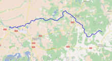
The Voire (French pronunciation: [vwaʁ]) is a small river in France, in the drainage basin of the Seine. It is 56.2 km (34.9 mi) long.[1] Its source is in Mertrud, in the Haute-Marne department. It flows through Montier-en-Der and Puellemontier, and empties into the river Aube at Chalette-sur-Voire, in the Aube department.
| Voire | |
|---|---|
 | |
 | |
| Location | |
| Country | France |
| Physical characteristics | |
| Mouth | |
• location | Aube |
• coordinates | 48°26′39″N 4°24′25″E |
| Length | 56.2 km (34.9 mi) |
| Basin size | 896 km2 (346 sq mi) |
| Discharge | |
| • average | 7.07 m3/s (250 cu ft/s) |
| Basin features | |
| Progression | Aube→ Seine→ English Channel |
References
This Grand Est geographical article is a stub. You can help Wikipedia by expanding it. |
На других языках
[de] Voire
Die Voire ist ein Fluss in Frankreich, der in der Region Grand Est verläuft. Sie entspringt im Gemeindegebiet von Dommartin-le-Franc, entwässert generell in westlicher Richtung und mündet nach rund 56[3] Kilometern unterhalb von Chalette-sur-Voire als rechter Nebenfluss in die Aube. Auf ihrem Weg durchquert die Voire die Départements Haute-Marne und Aube.- [en] Voire
[ru] Вуар
Вуар (фр. Voire) — река в департаментах Верхняя Марна и Об региона Гранд-Эст на северо-востоке Франции. Приток реки Об бассейна Сены. Начинается у Мертрю.Текст в блоке "Читать" взят с сайта "Википедия" и доступен по лицензии Creative Commons Attribution-ShareAlike; в отдельных случаях могут действовать дополнительные условия.
Другой контент может иметь иную лицензию. Перед использованием материалов сайта WikiSort.org внимательно изучите правила лицензирования конкретных элементов наполнения сайта.
Другой контент может иметь иную лицензию. Перед использованием материалов сайта WikiSort.org внимательно изучите правила лицензирования конкретных элементов наполнения сайта.
2019-2026
WikiSort.org - проект по пересортировке и дополнению контента Википедии
WikiSort.org - проект по пересортировке и дополнению контента Википедии