geo.wikisort.org - River
Amnicon Falls State Park is a state park of Wisconsin, United States. The 828-acre (335 ha) park is located in South Range, Wisconsin, southeast of the city of Superior. It features a series of waterfalls on the Amnicon River as it flows around a small island and under a historic covered bridge.
State park in Douglas County, Wisconsin
| Amnicon Falls State Park | |
|---|---|
IUCN category III (natural monument or feature) | |
 Amnicon Falls State Park's signature covered bridge | |
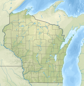  | |
| Location | Douglas, Wisconsin, United States |
| Coordinates | 46°36′50″N 91°53′58″W |
| Area | 828 acres (335 ha)[1] |
| Established | 1961 |
| Governing body | Wisconsin Department of Natural Resources |
| Website | Amnicon Falls State Park |
Activities and amenities
The falls are divided into Upper and Lower Falls areas, and swimming is allowed at both.
The park's 1.8 miles (2.9 km) of trails include paths along both banks of the river and a snowshoeing trail into remoter park areas.
The park has 36 campsites, two walk-in and one accessible to persons with disabilities.
References
- "History: Amnicon Falls State Park". Wisconsin Department of Natural Resources. Retrieved September 11, 2022.
External links
Wikimedia Commons has media related to Amnicon Falls State Park.
- Amnicon Falls State Park Wisconsin Department of Natural Resources
Protected areas of Wisconsin | |||||||||||||||||
|---|---|---|---|---|---|---|---|---|---|---|---|---|---|---|---|---|---|
| Federal |
| ||||||||||||||||
| State |
| ||||||||||||||||
Wisconsin Department of Natural Resources | |||||||||||||||||
| Authority control: National libraries |
|---|
Текст в блоке "Читать" взят с сайта "Википедия" и доступен по лицензии Creative Commons Attribution-ShareAlike; в отдельных случаях могут действовать дополнительные условия.
Другой контент может иметь иную лицензию. Перед использованием материалов сайта WikiSort.org внимательно изучите правила лицензирования конкретных элементов наполнения сайта.
Другой контент может иметь иную лицензию. Перед использованием материалов сайта WikiSort.org внимательно изучите правила лицензирования конкретных элементов наполнения сайта.
2019-2026
WikiSort.org - проект по пересортировке и дополнению контента Википедии
WikiSort.org - проект по пересортировке и дополнению контента Википедии