geo.wikisort.org - River
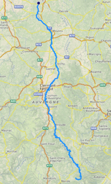
The Allier (UK: /ˈælieɪ/ AL-ee-ay,[1] US: /ælˈjeɪ, ɑːlˈjeɪ/ a(h)l-YAY,[2][3] French: [alje] (![]() listen); Occitan: Alèir) is a river in central France. It is a left tributary of the Loire. Its source is in the Massif Central, in the Lozère department, east of Mende. It flows generally north. It joins the Loire west of the city of Nevers. It is 421 km (262 mi) long, and has a drainage basin of 14,350 km2 (5,540 sq mi).[4]
listen); Occitan: Alèir) is a river in central France. It is a left tributary of the Loire. Its source is in the Massif Central, in the Lozère department, east of Mende. It flows generally north. It joins the Loire west of the city of Nevers. It is 421 km (262 mi) long, and has a drainage basin of 14,350 km2 (5,540 sq mi).[4]
| Allier | |
|---|---|
 Bridge over the Allier | |
 | |
| Native name | Alèir (Occitan) |
| Location | |
| Country | France |
| Physical characteristics | |
| Source | |
| • location | Massif Central |
| • elevation | 1,503 m (4,931 ft) |
| Mouth | |
• location | Loire |
• coordinates | 46°57′34″N 3°4′44″E |
| Length | 421 km (262 mi) |
| Basin size | 14,350 km2 (5,540 sq mi) |
| Discharge | |
| • average | 140 m3/s (4,900 cu ft/s) |
| Basin features | |
| Progression | Loire→ Atlantic Ocean |
Departments and towns
The Allier flows through the following departments, and along the following towns:
- Allier: Moulins, Varennes-sur-Allier, Vichy, Saint-Yorre
- Ardèche - the river runs along the border between this department and Lozère
- Cher: Mornay-sur-Allier, Château-sur-Allier
- Haute-Loire: Brioude, Langeac, Monistrol-d'Allier
- Lozère: Langogne, La Bastide-Puylaurent
- Nièvre
- Puy-de-Dôme: Brassac-les-Mines, Auzat-sur-Allier, Issoire, Cournon-d'Auvergne, Pont-du-Château, Cournon-d'Auvergne
Tributaries
The main tributaries of the Allier are:
- Chapeauroux (left side)
- Senouire (right side)
- Alagnon (left side)
- Anse
- Couze Pavin (left side)
- Dore (right side)
- Dolore (left side)
- Morge (left side)
- Sioule (left side)
- Monne (left side)
- Veyre (left side)
Ecology

The Allier is one of the rare places in southern Europe where the freshwater grayling (Thymallus thymallus), known in French as ombre des rivières, occurs in a natural habitat.[5]
Grayling like to live in shoals and are sensitive to pollution. In the Allier these fish are more abundant in the stretch between Langogne and Brioude. They are economically important, being appreciated for food and fished for sport.
Gallery
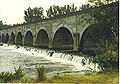 The bridge Le Guétin.

References
- "Allier". Lexico UK English Dictionary. Oxford University Press. Archived from the original on 2019-12-29.
- "Allier". Collins English Dictionary. HarperCollins. Retrieved 21 August 2019.
- "Allier". Merriam-Webster Dictionary. Retrieved 21 August 2019.
- Sandre. "Fiche cours d'eau (K---0080)".
- "The grayling zones of rivers and their tributaries" (PDF). Archived from the original (PDF) on 2009-02-07. Retrieved 2009-01-14.
Authority control | |
|---|---|
| General | |
| National libraries | |
| Other |
|
This Auvergne-Rhône-Alpes geographical article is a stub. You can help Wikipedia by expanding it. |
This Bourgogne-Franche-Comté geographical article is a stub. You can help Wikipedia by expanding it. |
This Occitania geographical article is a stub. You can help Wikipedia by expanding it. |
На других языках
[de] Allier
Der Allier ist ein ca. 421 km langer Fluss in Zentralfrankreich. Er entspringt in den Cevennen etwa 50 km östlich von Mende und mündet ca. 5 km westlich von Nevers in die Loire.- [en] Allier (river)
[es] Río Allier
El río Allier (en occitano Alèir o Alièr) es un río de Francia, afluente del Loira por la izquierda. Nace al pie del Moure de la Gardille, a 1503 m de altitud, en el departamento de Lozère. Desemboca en el Loira en el bec-d’Allier (bec indica confluencia de dos ríos), cerca de Nevers, en el límite de los departamentos de Nièvre y Cher, a 167 m sobre el nivel del mar, y tras un curso de 410 km. Su cuenca drena un área de 14.321 km².[it] Allier (fiume)
L'Allier (in occitano Alèir) è un fiume del centro della Francia, principale affluente della Loira per lunghezza, che ha dato il proprio nome al dipartimento dell'Allier.[ru] Алье (река)
Алье́ (фр. Allier) — река в Центральной Франции, один из крупных притоков Луары. Длина 421 км, средний расход воды 140 м³/с. Площадь бассейна 14321 км².Другой контент может иметь иную лицензию. Перед использованием материалов сайта WikiSort.org внимательно изучите правила лицензирования конкретных элементов наполнения сайта.
WikiSort.org - проект по пересортировке и дополнению контента Википедии