geo.wikisort.org - River
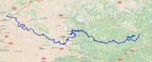
The Agout or Agoût (French pronunciation: [aɡu]; Occitan: Agot) is a 194.4-kilometre (120.8 mi) long river in south-western France. It is a left tributary of the Tarn.[1] Its source is in the southern Massif Central, in the Haut-Languedoc Regional Nature Park. It flows generally west through the following department and towns:
| Agout | |
|---|---|
 | |
 | |
| Location | |
| Country | France |
| Physical characteristics | |
| Source | |
| • location | Massif Central |
| Mouth | |
• location | Tarn |
• coordinates | 43°47′4″N 1°41′1″E |
| Length | 194.4 km (120.8 mi) |
| Basin size | 3,500 km2 (1,400 sq mi) |
| Discharge | |
| • average | 55 m3/s (1,900 cu ft/s) |
| Basin features | |
| Progression | Tarn→ Garonne→ Gironde estuary→ Atlantic Ocean |
The Agout flows into the Tarn at Saint-Sulpice.
Among its tributaries are the Dadou, the Gijou and the Thoré.
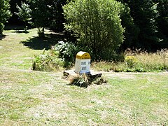 Cambon-et-Salvergues


References
| Wikimedia Commons has media related to Agout. |
Authority control | |
|---|---|
| General |
|
| National libraries | |
This Occitania geographical article is a stub. You can help Wikipedia by expanding it. |
На других языках
[de] Agout (Fluss)
Der Agout ist ein Fluss im Süden Frankreichs, der in der Region Okzitanien verläuft. Er entspringt in den Monts de l’Espinouse, an der Südwest-Flanke des gleichnamigen Gipfels Sommet de l’Espinouse, im Gemeindegebiet von Cambon-et-Salvergues. Auf seinem Weg berührt der die Départements Hérault und Tarn.- [en] Agout
[it] Agout
L'Agout è un fiume della Francia meridionale, affluente del Tarn, lungo 194 km.[1] Nasce sul Massiccio dell'Espinouse, nel dipartimento dell'Hérault, e sfocia presso Saint-Sulpice-la-Pointe, nel Tarn.[ru] Агу (река)
Агу́[1] (фр. Agout, окс. Agot) — река на юге Франции, в регионе Окситания. Длина — 194,39 км[2], площадь бассейна — около 3500 км²[источник не указан 122 дня]. Приток Тарна[3].Текст в блоке "Читать" взят с сайта "Википедия" и доступен по лицензии Creative Commons Attribution-ShareAlike; в отдельных случаях могут действовать дополнительные условия.
Другой контент может иметь иную лицензию. Перед использованием материалов сайта WikiSort.org внимательно изучите правила лицензирования конкретных элементов наполнения сайта.
Другой контент может иметь иную лицензию. Перед использованием материалов сайта WikiSort.org внимательно изучите правила лицензирования конкретных элементов наполнения сайта.
2019-2026
WikiSort.org - проект по пересортировке и дополнению контента Википедии
WikiSort.org - проект по пересортировке и дополнению контента Википедии