geo.wikisort.org - River
The Gironde estuary (/ʒɪˈrɒnd/ zhi-ROND,[1] US usually /dʒɪˈ-/ ji-;[2][3] French: estuaire de la Gironde, [ɛstɥɛʁ də la ʒiʁɔ̃d]; Occitan: estuari de [la] Gironda, [estyˈaɾi ˈde lo dʒiˈɾundo]) is a navigable estuary (though often referred to as a river) in southwest France and is formed from the meeting of the rivers Dordogne and Garonne just downstream of the centre of Bordeaux. Covering around 635 km2 (245 sq mi), it is the largest estuary in western Europe.[4]
| Gironde | |
|---|---|
 The Gironde estuary in Pauillac | |
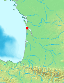 Map of France with the Gironde highlighted | |
| Location | |
| Country | France |
| Region | Nouvelle-Aquitaine |
| Physical characteristics | |
| Mouth | Atlantic Ocean |
| Length | 75 km (47 mi) |
| Basin size | 635 km2 (245 sq mi) |
| Width | |
| • minimum | 3 km (1.9 mi) |
| • maximum | 12 km (7.5 mi) |
| Basin features | |
| Tributaries | |
| • left | Garonne |
| • right | Dordogne |
Named after the French département Gironde, the Gironde estuary is approximately 75 km (47 mi) long and 3–12 km (2–7 miles) wide. It is subject to very strong tidal currents and great care is needed when navigating the estuary by any size or type of boat.
Since 2015, the Gironde estuary has been part of the Gironde estuary and Pertuis sea Marine Nature Park.[5]
Islands of the Gironde

Within the estuary between the Pointe de Grave at the seaward end and the Bec d'Ambès are a series of small islands.
The Île de Patiras is 200 ha in size with a lighthouse to aid navigation in the estuary. Vines and maize are grown there.
The Île Sans-Pain and Île Bouchaud are now virtually joined due to progressive silting and are referred to as the Ile Nouvelle. They total about 265 ha and are owned by the Conservatoire du Littoral and managed by the Department of the Gironde.
The Île Paté is about 13 ha and in 2006 was privately owned. The island has a historic fort built between 1685 and 1693 as part of the national fortification program masterminded by Vauban. The building is oval in shape, about 12 metres high and was originally equipped with about 30 cannons. Fort Paté, together with Fort Médoc and the ancient citadelle of Blaye, defended the estuary and Bordeaux. During the French Revolution the fort was used as a prison for priests.
In 2006, the Conseil General decided to make the island a ZPENS (zone de pre-emption espace naturel sensible). ZPENS status protects the island from development. If the owner wishes to sell the island, then the Department has a pre-emptive right. After two months the Conservatoire National du Littoral has the next pre-emptive right and then after another 2 months the town of Blaye has a final pre-emptive right to acquire the island.
The Île Verte, Île du Nord and Île Cazeau comprise about 800 ha and because of their natural state provide a fine stopping off place for migrating birds.
The Île Margaux is 25 ha and in 2005 had 14 ha devoted to vines and is part of the world famous Médoc wine region.
The Île Sans Nom which appeared in 2009 following Cyclone Klaus lies around 1 mile (1.6 km) east of Cordouan Lighthouse.[6]
Second World War

In December 1942, during the Second World War, Operation Frankton took place with the goal of destroying ships moored at the docks in Bordeaux.
The plan was for six kayaks (called "canoes" by the British) to be taken to the area of the Gironde estuary by submarine. Twelve men would then paddle by night to Bordeaux. On arrival they would attach timed limpet mines to the docked cargo ships and escape overland to Spain.
The raid was carried out by a small unit of Royal Marines known as the Royal Marines Boom Patrol Detachment (RMBPD), part of Combined Operations, led by Herbert 'Blondie' Hasler. They succeeded in slipping into the harbour unnoticed and sank one ship and severely damaged four others. Only two of the men returned to the UK alive, but they did enough damage to greatly disrupt the use of the harbour for the following months.[7]
The prototypes of the Char B1 ter heavy tank were lost in the Gironde as a result of German bombing in 1940.[8]
References
- The information relating to the protected status of Île Paté and the general information relating to the other islands is public domain information which was summarised as part of an article in the regional 'Sud Ouest' newspaper dated 3 October 2006.
- "Gironde". Lexico UK English Dictionary. Oxford University Press. Archived from the original on 2020-08-01.
- "Gironde". Collins English Dictionary. HarperCollins. Retrieved 28 August 2019.
- "Gironde". Merriam-Webster Dictionary. Retrieved 28 August 2019.
- (C) Parc naturel marin sur l'estuaire de Gironde et sur les Pertuis Charentais : l'étude est lancée Archived 2011-05-09 at the Wayback Machine Agence des aires marines protégées/French Marine Protected Areas Agency, published 2008-07-25, accessed 2011-03-30
- "Machine Translation of "Decree No. 2015-424 of April 15, 2015, for the Establishment of the Marine Park of the Estuary of the Gironde and the Se..." (France)".
- Tearse, Graham (11 August 2010). "Fragile habitat of French mystery island 'risks being trampled underfoot'". The Guardian. Retrieved 15 August 2020.
- "Hayling Island's secret canoes".
- Stéphane Ferrard, 2014, "Du Char B à l'ARL 44, un long cheminement (II). 1937-1940 : Ce Mal Aimé. Le char B 1ter", Histoire de Guerre, Blindés & Matériel 109: 67-78
Authority control | |
|---|---|
| General |
|
| National libraries | |
На других языках
[de] Gironde (Ästuar)
Die Gironde ist ein Ästuar in Südwestfrankreich, das vom Zusammenfluss der Flüsse Garonne und Dordogne bis zum Übergang in den Atlantik im Golf von Biskaya reicht. Sie ist etwa 75[2] Kilometer lang, bis zu 15 Kilometer breit und verläuft in nordnordwestlicher Richtung. Mit 685 km² Oberfläche ist sie der größte Mündungstrichter Europas. Nach der Gironde ist das größtenteils am linken Ufer gelegene Département Gironde benannt; ihm gegenüber am rechten Ufer liegt das Département Charente-Maritime.- [en] Gironde estuary
[it] Estuario della Gironda
L'estuario della Gironda (detto anche semplicemente Gironda) è un estuario del sud ovest della Francia, situato all'interno della regione della Nuova Aquitania (dipartimento della Gironda e della Charente Marittima). È l'estuario comune dei fiumi Garonna e Dordogna.[ru] Жиронда (эстуарий)
Жиро́нда (фр. Gironde) — эстуарий рек Гаронна и Дордонь[1], во Франции. Открывается в Бискайский залив. Длина 75—80 км, наименьшая глубина на фарватере 8 м. Порт Ле-Вердон.Другой контент может иметь иную лицензию. Перед использованием материалов сайта WikiSort.org внимательно изучите правила лицензирования конкретных элементов наполнения сайта.
WikiSort.org - проект по пересортировке и дополнению контента Википедии