geo.wikisort.org - Reservoir
Śniardwy (German: ![]() der Spirdingsee (help·info))[1] is a lake in the Masurian Lake District of the Warmian-Masurian Voivodeship, Poland.
der Spirdingsee (help·info))[1] is a lake in the Masurian Lake District of the Warmian-Masurian Voivodeship, Poland.
| Śniardwy | |
|---|---|
 | |
 Śniardwy 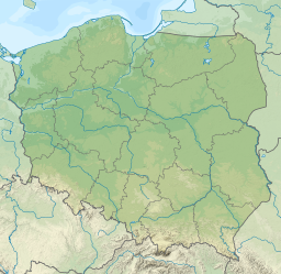 Śniardwy | |
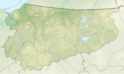
| Location | Masurian Lake District |
| Coordinates | 53°46′N 21°45′E |
| Type | Glacial lake |
| Basin countries | Poland |
| Max. length | 22.1 km (13.7 mi) |
| Max. width | 13.4 km (8.3 mi) |
| Surface area | 113.8 km2 (43.9 sq mi) |
| Average depth | 6.5 m (21 ft) |
| Max. depth | 23 m (75 ft) |
| Water volume | 0.65 km3 (530,000 acre⋅ft) |
| Surface elevation | 117 m (384 ft) |
| Islands | 8 |
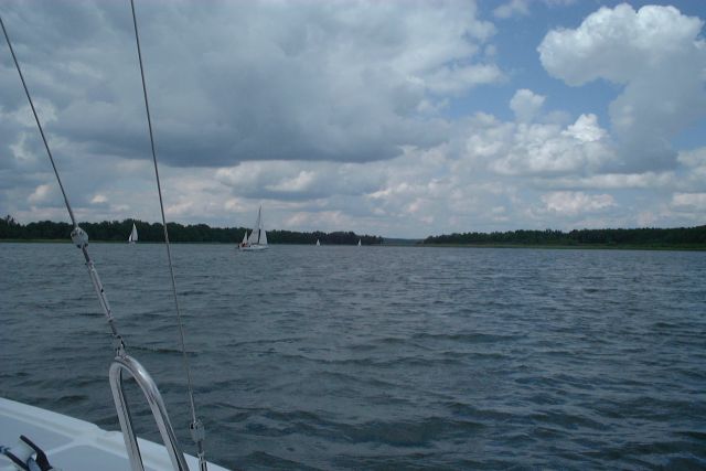
At 113.8 square kilometres (43.9 sq mi), Śniardwy is the largest lake in Poland. It was also the largest lake in Prussia, when Warmia-Masuria was under German rule.[2] It is 22.1 kilometres (13.7 mi) long and 13.4 kilometres (8.3 mi) wide. The maximum depth is 23 metres (75 feet). There are eight islands on the Śniardwy lake.[3]
Geography
Śniardwy was formed by retreating ice sheet and draining floodwaters occurring as the result of ice calving ahead of the receding glacier. Among the eight islands are: Szeroki Ostrów, Czarci Ostrów, Wyspa Pajęcza, Wyspa Kaczor and others. Surrounding settlements include Popielno, Głodowo, Niedźwiedzi Róg, Okartowo, Nowe Guty, Zdęgowo and Łuknajno.[3]
Among the many inlets, two are named as separate lakes: Warnołty and Seksty. Śniardwy connects with the following lakes: Tuchlin, Łuknajno, Mikołajskie, Roś, Białoławki and Tyrkło. It is surrounded by the system of canals known as Kanały Mazurskie (Masurian Canals), with numerous sluices. Together, they form the Polish Masurian Lake District.[3]
Bibliography
- Bednarz, Klaus (June 2010). Ferne und Nähe (in German). ISBN 978-3-498-00635-8.
- . Encyclopædia Britannica. Vol. 08 (11th ed.). 1911.
- Lake Śniardwy at the International Lake Environment Committee webpage
- J. Szynkowski, Mazury. Przewodnik, Kengraf Kętrzyn, 2003
Authority control | |
|---|---|
| General |
|
| National libraries | |
This Mrągowo County location article is a stub. You can help Wikipedia by expanding it. |
На других языках
[de] Śniardwy
Der Śniardwy (.mw-parser-output .IPA a{text-decoration:none}[ˈɕɲardvɨ], deutsch Spirdingsee) ist ein 114 km² großer See in der polnischen Woiwodschaft Ermland-Masuren. Der im historischen Ostpreußen gelegene See ist der größte See Polens und war bis 1945 der größte vollständig in Deutschland gelegene Binnensee (der größte heute vollständig in Deutschland gelegene Binnensee, die Müritz, ist 112,6 km² groß). Der Spirdingsee gehört zur Masurischen Seenplatte und ist 22,1 km lang und 13,4 km breit. Der nächstgrößte masurische See, der Mauersee, ist 104 km² groß.- [en] Śniardwy
[fr] Śniardwy
Le Śniardwy est un lac de la région des lacs de Mazurie en Pologne.[it] Lago Śniardwy
Il lago Śniardwy (in tedesco: Spirdingsee) è un lago della Polonia situato nella Terra dei laghi della Masuria, nel voivodato della Varmia-Masuria. È il più grande lago dello Stato con una superficie di 113,8 chilometri quadrati.[ru] Снярдвы
Сня́рдвы[1][2] (польск. Śniardwy; устар. нем. Spirdingsee) — самое большое озеро Польши.Другой контент может иметь иную лицензию. Перед использованием материалов сайта WikiSort.org внимательно изучите правила лицензирования конкретных элементов наполнения сайта.
WikiSort.org - проект по пересортировке и дополнению контента Википедии