geo.wikisort.org - Reservoir
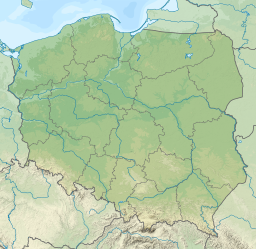
Mikołajskie Lake (Polish: Jezioro Mikołajskie; German: Nikolaiker See) is glacial lake in Masurian Lake District in Poland.
This article does not cite any sources. (October 2013) |
| Mikołajskie Lake | |
|---|---|
 View of the lake and the Mikołajki harbor | |
 Mikołajskie Lake | |
| Location | Masurian Lake District, Masuria, Poland |
| Coordinates | 53.777°N 21.591°E |
| Native name | Jezioro Mikołajskie (Polish) |
| Max. length | 5.8 km (3.6 mi) |
| Max. width | 1.6 km (0.99 mi) |
| Surface area | 5 km2 (1.9 sq mi) |
| Max. depth | 25.9 m (85 ft) |
Mikołajskie Lake covers 5 square kilometres (1.9 sq mi) and is 5.8 kilometres (3.6 mi) long and 1.6 kilometres (0.99 mi) wide with a maximum depth of 25.9 meters.
In the north, Mikołajskie Lake is connected with the Tałty Lake under the road bridge in Mikołajki. To one of the pillars of the bridge, on a spring, is chained the King of Vendaces (Fish King, in Polish: Król Sielaw, Rybi Król, legendary king of Masuria). In the south-east, Mikołajskie Lake is connected with the Śniardwy Lake by the Przeczka strait within Dybowski Róg and Popielski Róg. In the south-west, Mikołajskie Lake is connected with the Bełdany Lake. On the west bank extends the Pisz Forest.
On the shore of the lake are the towns: Mikołajki, Dybowo, Kulinowo, Wierzba.
Notable wildlife:
- Eurasian bittern (Botaurus stellaris)
- Common goldeneye (Bucephala clangula)
- Ruff (Philomachus pugnax)
- Black-throated loon (Gavia arctica)
- Little gull (Larus minutus)
На других языках
[de] Jezioro Mikołajskie
Jezioro Mikołajskie (deutsch: Nikolaiker See) ist ein See auf dem Gebiet der polnischen Stadt Mikołajki (deutsch Nikolaiken) im Powiat Mrągowski in der Woiwodschaft Ermland-Masuren.- [en] Mikołajskie Lake
Другой контент может иметь иную лицензию. Перед использованием материалов сайта WikiSort.org внимательно изучите правила лицензирования конкретных элементов наполнения сайта.
WikiSort.org - проект по пересортировке и дополнению контента Википедии