geo.wikisort.org - Reservoir
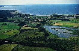
Paviken is a lake in Västergarn on the western side of the island of Gotland. The lake is a popular birding and fishing site.
| Paviken Paveikgan (Gutnish) | |
|---|---|
 Västergarn and Paviken | |
 Paviken Paveikgan (Gutnish) | |
| Location | Västergarns socken, Gotland |
| Coordinates | 57.45519°N 18.14070°E |
| Type | freshwater lake |
| Primary outflows | Idå |
| Catchment area | 20.48 km2 (7.91 sq mi)[1] |
| Basin countries | Sweden |
| Surface area | 0.272 km2 (0.105 sq mi)[2] |
| Shore length1 | 2.63 km (1.63 mi)[3] |
| Surface elevation | 0 m (0 ft)[2] |
| Frozen | winter |
| 1 Shore length is not a well-defined measure. | |
The lake is drained by the river Idå. The lake and its surroundings form a nature reserve which is more populated by birds than any other reserve on the island. In 1994, the reserve was designated a Natura 2000 area. During spring and autumn it is a stop-over site for migratory birds, a total of 240 species has been observed in the area. The lake offers fishing principally for perch and pike.[4][5]
During the Viking Age, Paviken was a sheltered bay and cove connected to the Baltic Sea by a narrow strait. It formed a natural harbour which was improved by jetties. These were built during the 8th century and were used for about 300 years until the harbour became too shallow. Subsequently, the harbour and commercial activity were moved to nearby Västergarn harbor. Dating from the early 1960s, archaeological investigations have found remains of port facilities, buildings and burial grounds.[4][6]
References
- "Svenskt Vattenarkiv – Delavrinningsområden (SVAR 2012)" [Swedish Water archive - Catchment area (SVAR 2012)]. www.smhi.se. SMHI. Retrieved 23 January 2015.
- "Sjölista" [List of lakes] (PDF). www.smhi.se. SMHI. Retrieved 23 January 2015.
- "Svenskt Vattenarkiv – Vattenytor (SVAR 2012)" [Swedish Water archive - Water surfaces]. www.smhi.se. SMHI. Retrieved 23 January 2015.
- "Paviken". www.lansstyrelsen.se (in Swedish). County Administrative Board of Gotland. Retrieved 24 January 2015.
- "Fisket i Paviken och Västergarnsån". Paviken.se. Retrieved March 25, 2016.
- Jenna Franklin (2013). "Paviken: A Viking Age Harbor Site" (PDF). American Institute of Archaeology. Retrieved March 20, 2016.
На других языках
[de] Paviken (See)
Der flache See Paviken ist das letzte sichtbare Zeugnis eines eisenzeitlichen Handelsplatzes an der Westküste der schwedischen Insel Gotland, der zwischen 800 und 1050 n. Chr. von den Wikingern genutzt wurde. Bis ins 10. Jahrhundert war Paviken ein Hafen in einer Meeresbucht, deren Zugang an der schmalsten Stelle etwa 100 m breit war. Durch die Landhebung von etwa 2,5 m in den letzten 1000 Jahren verlor der Hafen im Mittelalter seine Bedeutung. Am Oststrand Pavikens mündet der heute kanalisierte Fluss Idå, der damals das inzwischen trockengelegte Vikmoor entwässerte.- [en] Paviken
Другой контент может иметь иную лицензию. Перед использованием материалов сайта WikiSort.org внимательно изучите правила лицензирования конкретных элементов наполнения сайта.
WikiSort.org - проект по пересортировке и дополнению контента Википедии
