geo.wikisort.org - Island
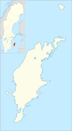
Gotska Sandön (literally translated as "The Gotlandic Sand Island") is an uninhabited Swedish island north of Gotland in the Baltic Sea. It has been a national park since 1909.
| Gotska Sandön National Park Gutniska Sandåi Nationalpark (Gutnish) | |
|---|---|
| Gotska sandöns nationalpark | |
IUCN category II (national park) | |
 The eastern coast, as seen from the lighthouse | |
  | |
| Location | Gotland County, Sweden |
| Nearest city | Fårösund, Gotland Municipality |
| Coordinates | 58°22′N 19°15′E |
| Area | 44.9 km2 (17.3 sq mi)[1] |
| Established | 1909, extended in 1963 and 1988[1] |
| Governing body | Naturvårdsverket |
Geography
Gotska Sandön is situated 38 km (24 mi) north of Fårö in the Baltic Sea. Legally a part of Gotland province, it is approximately 9 km (5.6 mi) long and 6 km (3.7 mi) wide, with a total area of approximately 36 km2 (14 sq mi). The island is part of Fårö socken (not to be confused with parish).[2] It comprises the same area as the administrative Fårö District, established on 1 January 2016.[3]
On the northwest tip of the island is a church, Gotska Sandön Chapel.[4] As of 2019[update], Gotska Sandön Chapel along with Fårö Church belong to Fårö parish in Norra Gotlands pastorat.[5][6]
During the summer, there are regular boat tours from Fårö Island and Nynäshamn on the mainland.
Nature of Gotska Sandön
The island consists mostly of sand and is dominated by beaches, dunes and especially pine forests. Aside from a colony of grey seals, the higher fauna is not very rich. Terrestrial or aerial mammals include mountain hares and bats. However, the island is home to many rare insects and plants, including the Kashubian vetch and several species of orchid.
Climate
Despite its isolation from sizeable landmasses, Gotska Sandön's oceanic climate is warm for its latitude. The Scandinavian Peninsula to the west, Gotland to the south and the Baltic landmass to the east contribute to warmer summers and frequent winter frost, giving the island a far broader temperature range than, for example, the similarly isolated Fair Isle, which lies one degree further north some distance off the coast of Scotland. In spite of this range, summer highs are cool by the standards of southern Sweden, and winter nights are among the mildest in the country.
Gotska Sandön has significant seasonal lag: despite dwindling daylight hours, August is much warmer than June, while March days are both longer and colder than those in December.
| Climate data for Gotska Sandön (2002–2018; extremes since 1901) | |||||||||||||
|---|---|---|---|---|---|---|---|---|---|---|---|---|---|
| Month | Jan | Feb | Mar | Apr | May | Jun | Jul | Aug | Sep | Oct | Nov | Dec | Year |
| Record high °C (°F) | 8.6 (47.5) |
9.6 (49.3) |
13.8 (56.8) |
21.8 (71.2) |
27.0 (80.6) |
29.0 (84.2) |
31.6 (88.9) |
31.1 (88.0) |
27.0 (80.6) |
18.6 (65.5) |
11.9 (53.4) |
9.8 (49.6) |
31.6 (88.9) |
| Mean maximum °C (°F) | 5.4 (41.7) |
5.0 (41.0) |
8.3 (46.9) |
14.3 (57.7) |
20.5 (68.9) |
23.3 (73.9) |
26.6 (79.9) |
26.1 (79.0) |
20.9 (69.6) |
15.3 (59.5) |
10.1 (50.2) |
7.0 (44.6) |
27.5 (81.5) |
| Average high °C (°F) | 1.7 (35.1) |
1.4 (34.5) |
3.6 (38.5) |
8.1 (46.6) |
13.6 (56.5) |
18.1 (64.6) |
21.9 (71.4) |
21.4 (70.5) |
16.8 (62.2) |
10.6 (51.1) |
6.7 (44.1) |
3.8 (38.8) |
10.6 (51.2) |
| Daily mean °C (°F) | 0.3 (32.5) |
−0.2 (31.6) |
1.3 (34.3) |
4.9 (40.8) |
10.0 (50.0) |
14.4 (57.9) |
18.4 (65.1) |
18.1 (64.6) |
14.2 (57.6) |
8.7 (47.7) |
5.1 (41.2) |
2.3 (36.1) |
8.1 (46.6) |
| Average low °C (°F) | −1.2 (29.8) |
−1.8 (28.8) |
−1.1 (30.0) |
1.7 (35.1) |
6.3 (43.3) |
10.7 (51.3) |
14.8 (58.6) |
14.7 (58.5) |
11.5 (52.7) |
6.7 (44.1) |
3.5 (38.3) |
0.8 (33.4) |
5.6 (42.0) |
| Mean minimum °C (°F) | −7.7 (18.1) |
−7.4 (18.7) |
−6.7 (19.9) |
−3.1 (26.4) |
0.4 (32.7) |
5.5 (41.9) |
9.7 (49.5) |
9.4 (48.9) |
5.7 (42.3) |
0.5 (32.9) |
−1.9 (28.6) |
−4.3 (24.3) |
−9.9 (14.2) |
| Record low °C (°F) | −22.0 (−7.6) |
−25.0 (−13.0) |
−23.2 (−9.8) |
−16.0 (3.2) |
−6.0 (21.2) |
−2.0 (28.4) |
3.1 (37.6) |
3.1 (37.6) |
−1.5 (29.3) |
−5.2 (22.6) |
−9.2 (15.4) |
−13.8 (7.2) |
−25.0 (−13.0) |
| Average precipitation mm (inches) | 43.9 (1.73) |
35.4 (1.39) |
27.1 (1.07) |
24.0 (0.94) |
27.1 (1.07) |
43.0 (1.69) |
50.0 (1.97) |
62.5 (2.46) |
42.9 (1.69) |
51.6 (2.03) |
58.0 (2.28) |
50.9 (2.00) |
516.4 (20.32) |
| Source 1: SMHI Open Data[7] | |||||||||||||
| Source 2: SMHI Monthly Data 2002–2018[8] | |||||||||||||

havet
Gallery
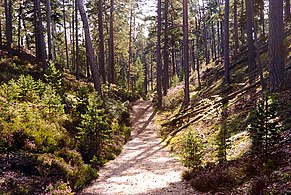 A track through the sand dunes, popularly called "Schipka Pass"
 The north-eastern coast


References
- "Gotska Sandön National Park". Naturvårdsverket. Archived from the original on 6 September 2015. Retrieved 26 February 2009.
- The exact extent of the socken, now district, can be obtained by clicking on Kartinställningar and check the Socken box in the menu of this map from the Swedish National Heritage Board database.
- "Förordning om district" [Regulation of districts] (PDF). Ministry of Finance. 17 June 2015. Retrieved 24 May 2016.
- "Gotska sandöns kapell". www.guteinfo.com. Guteinfo. Retrieved 11 January 2019.
- "Församlingar på Gotland". www.svenskakyrkan.se. Church of Sweden. Retrieved 11 January 2019.
- "Visby stifts indelning 2018". www.svenskakyrkan.se. Church of Sweden. Retrieved 11 January 2019.
- "SMHI öppen data för Gotska Sandön" (in Swedish). Swedish Meteorological and Hydrological Institute.
- "Monthly and Yearly Statistics" (in Swedish). Swedish Meteorological and Hydrological Institute. 1 July 2019. Archived from the original on 22 December 2013. Retrieved 7 April 2015.
External links
![]() Media related to Gotska Sandön at Wikimedia Commons
Media related to Gotska Sandön at Wikimedia Commons
- Sweden's National Parks: Gotska Sandön National Park from the Swedish Environmental Protection Agency
- Gotska Sandön (in Swedish)
- Gotska Sandön National Park (in Swedish)
- Gotska Sandön National Park (English)
- Birds on Gotska Sandön
Gotland Municipality, Gotland County, Sweden | ||
|---|---|---|
| Sockens: |
|  |
| Localities: | ||
| Settlements: |
| |
| Lakes: |
| |
| Streams: | ||
| Islands: |
| |
| Peninsulas: |
| |
| Hills: |
| |
| ||
Authority control | |
|---|---|
| General |
|
| National libraries | |
На других языках
[de] Gotska Sandön
Gotska Sandön ist eine schwedische Insel in der Ostsee, 40 km nördlich von Fårö. Sie ist ca. 8 km lang, 5 km breit und hat eine Fläche von 3.601 ha. Während des Krimkrieges diente sie als britische Marine-Basis.[1] Die Insel ist seit 1963[2] Teil des Nationalparks Gotska Sandön.- [en] Gotska Sandön
[fr] Gotska Sandön
Gotska Sandön, toponyme suédois signifiant littéralement « l'île de sable de Gotland », est une île de la mer Baltique dans le comté de Gotland, en Suède. L'île est très isolée, située à 38 kilomètres au nord de l'île de Fårö, une autre île juste au nord de Gotland. Elle constitue la partie émergée d'un long récif la reliant à Gotland formé par les moraines datant des dernières glaciations. La côte de Gotska Sandön est dominée par des plages et dunes tandis qu'à l'intérieur des terres s'étend une vaste forêt de pins parsemées de quelques dunes fixées formant les rares reliefs de l'île dont son point culminant avec 42 mètres d'altitude. Le climat relativement sec et le sol sablonneux ne contribuent pas au développement de la flore, plutôt pauvre hormis dans les quelques dépressions qui parviennent à conserver l'humidité, et de la faune, à l'exception de nombreux insectes rares (notamment des coléoptères), des oiseaux de mer et des phoques sur le littoral qui parviennent à s'affranchir de l'isolement de l'île plus facilement que des espèces strictement terrestres. Gotska Sandön est tout de même appréciée par les visiteurs pour son avifaune et ses mammifères marins.[it] Gotska Sandön
Gotska Sandön è un'isola disabitata della Svezia, situata nel mar Baltico, a nord di Gotland.[ru] Готска-Сандён
Готска-Сандён (швед. Gotska Sandön) — остров в Балтийском море. Площадь — 36,54 км². Принадлежит Швеции, входит в лен Готланд.Другой контент может иметь иную лицензию. Перед использованием материалов сайта WikiSort.org внимательно изучите правила лицензирования конкретных элементов наполнения сайта.
WikiSort.org - проект по пересортировке и дополнению контента Википедии