geo.wikisort.org - Reservoir
Lake El'gygytgyn (Russian and Chukchi: Эльгыгытгын) is an impact crater lake located in the Chukotka Autonomous Okrug in northeast Siberia, about 150 km (93 mi) southeast of Chaunskaya Bay.
| El'gygytgyn Lake | |
|---|---|
 View of the lake | |
 El'gygytgyn Lake Location in Chukotka, Russia | |
| Location | Chukchi Peninsula, northeast Siberia |
| Coordinates | 67°30′N 172°00′E |
| Type | Impact crater lake, oligotrophic |
| Primary outflows | Enmyvaam |
| Catchment area | 293 km2 (113 sq mi) |
| Basin countries | Russia |
| Max. length | 12 km (7.5 mi) |
| Max. width | 12 km (7.5 mi) |
| Surface area | 110 km2 (42 sq mi) |
The word "Elgygytgyn" means "white lake" in the Chukchi language.
The lake is of particular interest to scientists because it has never been covered by glaciers. This has allowed the uninterrupted build-up of 400 m (1,300 ft) of sediment at the bottom of the lake, recording information on prehistoric climate change.
Geography
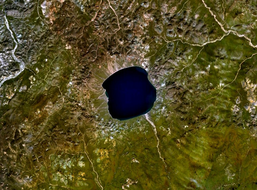
Lake El'gygytgyn is located in the Anadyr Plateau, part of the Anadyr Highlands. It is drained to the southeast by the Enmyvaam, a tributary of the Belaya. It is approximately 12 km (7 mi) in diameter and has a maximum depth of 174 ± 2 m (571 ± 7 ft). The lake is centered within an impact crater with a rim diameter of 18 km (11 mi) that formed 3.6 million years ago during the Pliocene.[1] Before it was reliably dated, preliminary papers in the late 1970s suggested either Elgygytgyn[2] or Zhamanshin[3] as the source of the young Australasian strewnfield.
Scientific drilling
In late 2008 and early 2009, an international team from the USA (Dr. Julie Brigham-Grette), Germany (Dr. Martin Melles), Russia (Dr. Pavel Sergeevich Minuyk) and Austria (Dr. Christian Koeberl) conducted a drilling program targeting three holes in El'gygytgyn Lake. The resulting cores are designated ICPD Site 5011-1 and 5011-3.[4] This co-sponsored by the International Continental Scientific Drilling Program (ICDP), with funding also provided by the U.S. National Science Foundation (NSF), the German Federal Ministry of Education and Research (BMBF), Alfred Wegener Institute (AWI) and GeoForschungsZentrum Potsdam (GFZ), the Russian Academy of Sciences Far East Branch (RAS FEB), the Russian Foundation for Basic Research (RFBR), and the Austrian Federal Ministry of Science and Research (BMWF).[4]
Fauna
The conditions in the El'gygytgyn lake are extremely severe for fish life. Even so, there are three species permanently inhabiting the lake's harsh aquatic environment.[5] These are three types of char: Salvelinus boganidae, S. elgyticus (Small-mouth char) and Salvethymus svetovidovi (long-finned char).[6] The two latter species are endemic to the El'gygytgyn lake. The golets (Salvelinus alpinus, Russian: голец) has been introduced recently. Fish species in the lake are adapted to its very cold waters, which are generally just above the freezing point, and spend most of the year in total darkness. The surface is frozen for about 10 months of the year. It may start to melt in the summer, but some years it never fully thaws.[7]
See also
References
- "El'gygytgyn". Earth Impact Database. Planetary and Space Science Centre University of New Brunswick Fredericton. Retrieved 2009-08-19.
- R.S. Dietz (1977), Elgygytgyn Crater, Siberia: Probable Source Of Australasian Tektite Field Meteoritics, June 1977, Vol 12, Issue 2, p. 145–157
- B.P. Glass (1979), Zhamanshin crater, a possible source of Australasian tektites? Geology, July 1979, v. 7, p. 351-353
- Melles; et al. (2011). "The Lake El'gygytgyn Scientific Drilling Project – Conquering Arctic Challenges through Continental Drilling". Scientific Drilling. 11 (10): 29. Bibcode:2011SciDr..11...29M. doi:10.2204/iodp.sd.11.03.2011.
- Fly Fishing Russia – The Elgygytgyn Lake, Chukotka
- Salvethymus svetovidovi
- Arctic char (Salvelinus alpinus) in the lake
External links
- Dr. Matt Nolan at the University of Alaska Fairbanks
- Polar Expedition to Siberian Lake will Yield Details of Past Climate PhysOrg.com.
- NASA Earth Observatory
- Haltia E. M., Nowaczyk N. R. Magnetostratigraphy of sediments from Lake El’gygytgyn ICDP Site 5011-1: paleomagnetic age constraints for the longest paleoclimate record from the continental Arctic, 2014.
Impact cratering on Earth | ||
|---|---|---|
| ||
| Lists |
|   |
| Confirmed≥20 km diameter |
| |
| Topics |
| |
| Research |
| |
Authority control | |
|---|---|
| General |
|
| National libraries | |
На других языках
[de] Elgygytgyn
Elgygytgyn (tschuktschisch Эльгыгытгын [.mw-parser-output .IPA a{text-decoration:none}ˈɛɬɣəˌɣətɣən] ‚Der weiße See‘, russisch Эльгыгы́тгын) ist ein See in Ostsibirien. Er liegt auf dem Anadyr-Plateau im Autonomen Kreis der Tschuktschen. Der See hat einen Durchmesser von etwa zwölf Kilometern und ist 169 Meter tief. Sein Name bezieht sich auf die lange Eisbedeckung: Der See ist neun Monate im Jahr mit Eis bedeckt. Lediglich von Mitte Juli bis Oktober ist er eisfrei.- [en] Lake Elgygytgyn
[es] Lago Elgygytgyn
El lago El'gygytgyn (en chucoto: Эльгыгытгын) es un lago localizado en la península de Chukotka, en el noreste de Siberia, perteneciente administrativamente al Distrito autónomo de Chukotka de la Federación de Rusia. Tiene un diámetro aproximado de 12 kilómetros una superficie de 119,5 km² y una profundidad de 175 metros, y está ubicado en un cráter de impacto de meterorito creado hace 3.6 millones de años en el Plioceno. El diámetro del cráter es de 18 km.[fr] Cratère El'guyguytguyne
Le cratère El'guyguytguyne, abritant le lac El'guyguytguyne (en russe : Эльгыгытгын), est un cratère d'impact situé dans le district autonome de Tchoukotka en Sibérie du nord-est. Le nom signifie en langue tchouktche « lac blanc ».[it] Lago El'gygytgyn
Il lago El'gygytgyn (in rus. Эльгыгытгын, pr. ˈɛɬɣəˌɣətɣən) si trova nella Russia estremo-orientale, nell'Anadyrskij rajon del Circondario autonomo della Čukotka.[ru] Эльгыгытгын
Эльгыгы́тгын[2] — кратерное озеро на Чукотке. Расположено на Анадырском плоскогорье, в Анадырском районе, примерно в 390 километрах к северо-западу от Анадыря.Другой контент может иметь иную лицензию. Перед использованием материалов сайта WikiSort.org внимательно изучите правила лицензирования конкретных элементов наполнения сайта.
WikiSort.org - проект по пересортировке и дополнению контента Википедии