geo.wikisort.org - Reservoir
Kostal Lake is a lake located in Wells Gray Provincial Park, east-central British Columbia, Canada. It is located west of Murtle Lake and east of Clearwater Lake.[1]
| Kostal Lake | |
|---|---|
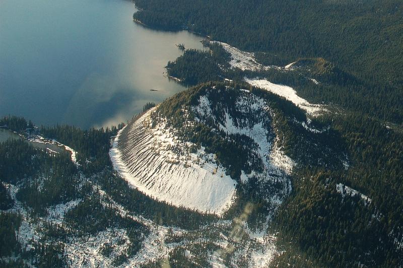 Lake and Kostal Volcano | |
 Kostal Lake | |
| Location | British Columbia |
| Coordinates | 52.164°N 119.976°W |
| Primary inflows | minor creeks |
| Primary outflows | Kostal Creek to File Creek to Murtle Lake |
| Basin countries | Canada |
| Max. length | 4.5 km (2.8 mi) |
| Max. width | 2.7 km (1.7 mi) |
| Surface elevation | 1,250 m (4,101 ft) |
| Islands | 3 |
Naming
Kostal Lake was named by Angus Horne in 1936 for Frank Kostal, one of the many trappers and prospectors who visited this remote region during the first quarter of the 20th century. Kostal had a cabin by the lake which he used when collecting animals from his trapline on Kilpill Mountain.
Access
Visits to Kostal Lake are rare due to difficult access. A trail from Clearwater Lake Campground was built in 1971 and originally extended 40 km (24.9 mi) to McDougall Lake and the west arm of Murtle Lake. The section beyond Kostal Lake has been impassable since the mid-1980s. The rest of the trail was permanently closed by B.C. Parks in 2013 and only the first 1.5 km (0.9 mi) from the campground as far as the Dragon's Tongue lava flow can still be used. A rigorous access route is still possible by canoe up File Creek, then a cross-country hike over the lava flow.[2]
Float planes and helicopters are not allowed to land at Kostal Lake. Landings are permitted at McDougall Lake, 6 km northeast. A permit from B.C. Parks is required.[2]
Geology
Kostal Volcano rises 150 m (492 ft) from the lake's northeast shore.
References
- "Kostal Lake". BC Geographical Names.
- Neave, Roland (2015). Exploring Wells Gray Park, 6th edition. Wells Gray Tours, Kamloops, BC. ISBN 978-0-9681932-2-8.
Другой контент может иметь иную лицензию. Перед использованием материалов сайта WikiSort.org внимательно изучите правила лицензирования конкретных элементов наполнения сайта.
WikiSort.org - проект по пересортировке и дополнению контента Википедии