geo.wikisort.org - Reservoir
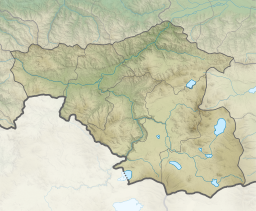
Khanchali Lake (Georgian: ხანჩალი) is a tectonic-volcanic lake[1] in Ninotsminda Municipality, Samtskhe–Javakheti region of Georgia.[2] Located in the central part of the Javakheti Plateau, at 1931 m above sea level. The area of its surface is 5 km2. The maximum depth of the lake is 1.4 m. The lake is fed by water from snow, rainfall and underground waters. Water levels are higher during spring and lower at the end of february.[3]
This article may be expanded with text translated from the corresponding article in Georgian. (March 2022) Click [show] for important translation instructions.
|
| Khanchali Lake | |
|---|---|
 Khanchali Lake | |
 Khanchali Lake  Khanchali Lake | |
| Coordinates | 41°15′25″N 43°32′55″E |
| Primary outflows | Agrichai |
| Basin countries | Georgia |
| Surface area | 5 km2 (1.9 sq mi) |
| Average depth | 0.5 m (1 ft 8 in) |
| Max. depth | 1.4 m (4 ft 7 in) |
| Surface elevation | 1,931 m (6,335 ft) |
 | |
There are 10 rivers that flow into the lake. The Agrichai river flows from the eastern side of the lake and after several kilometres it joins the Paravani river left side. The annual level amplitude is 1 m. Khanchali is the most disturbed one as it experienced heavy anthropogenic changes in the last 50 years. In particular, the shape and water level of Khanchali was altered several times to meet industrial needs during the Soviet time and after. Between 1968 and 1980, the lake was completely dried up for agricultural purposes.[4] In 1997 the lake was swelled; Currently, it is half of its original size after the amelioration[disambiguation needed][clarification needed] of the north-western part of the lake for agricultural purposes. Khanchali Lake is part of Khanchali Managed Reserve.[5]
The villages of Didi Khanchali and Patara Khanchali lie around the lake, and the town Ninotsminda is located nearby.[6]
See also
References
- საქართველოს კლიმატური და ჰიდროლოგიური ელემენტების შესწავლისათვის. 1966. გვ. 54–61 (in georgian)
- Orthographic dictionary of geographic names of Georgian, p. 223, Tbilisi, 2009
- Ilia Apkhazava. Lakes of Georgia (in russian), pp. 135–137, Tbilisi, Metsniereba, 1975
- Matcharashvili, I.; Arabuli, G.; Darchiashvili, G.; Gorgadze G. Javakheti Wetlands: Biodiversity and Conservation. 2004.
- ჯავახეთის დაცული ტერიტორიების შექმნისა და მართვის შესახებ
- Agency of Protected Areas of Georgia | Khanchali Lake
| Eastern Georgia |
| ||||
|---|---|---|---|---|---|
| Western Georgia |
| ||||
На других языках
- [en] Khanchali Lake
[fr] Lac Khantchali
Le lac Khantchali est un lac géorgien faisant partie de la région de Samtskhé-Djavakhétie. Situé à 1 928 mètres au-dessus du niveau de la mer, il n'est guère profond et sa profondeur maximale n'est que de 70 centimètres. Le lac contient toutefois des espèces de poissons et attire les pêcheurs géorgiens et arméniens.[ru] Ханчали
Ханчали (груз. ხანჩალი) — озеро в Грузии, расположено на территории Ниноцминдского муниципалитета края Самцхе-Джавахети. Название происходит от близлежащего села Диди-Ханчали.Другой контент может иметь иную лицензию. Перед использованием материалов сайта WikiSort.org внимательно изучите правила лицензирования конкретных элементов наполнения сайта.
WikiSort.org - проект по пересортировке и дополнению контента Википедии