geo.wikisort.org - Reservoir
Hyrum State Park is a state park and reservoir in Cache County, Utah, United States.
| Hyrum State Park | |
|---|---|
IUCN category V (protected landscape/seascape) | |
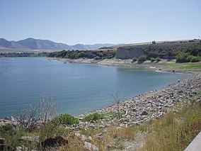 Hyrum Reservoir viewed from over the dam | |
 Location of Hyrum State Park in Utah  Hyrum State Park (the United States) | |
| Location | Cache, Utah, United States |
| Coordinates | 41°37′13″N 111°51′27″W |
| Area | 264 acres (107 ha)[1] |
| Elevation | 4,700 ft (1,400 m)[2] |
| Established | 1959[2] |
| Named for | Hyrum Smith |
| Visitors | 89885 (in 2011)[3] |
| Operator | Utah State Parks |
Hyrum State Park is in the northeastern part of Utah. It lies at 4,700 feet (1,400 m), and consists of 265 acres (1.07 km2) surrounding a 450-acre (1.8 km2) reservoir. The park is used for fishing, boating, camping, picnicking, hiking, waterskiing, and swimming.
The park was named for Hyrum Smith, the brother of LDS church founder Joseph Smith.[2]
Hyrum State Park's facilities are located at the northern shore of the reservoir, and include 31 RV campsites, restrooms, showers, a ranger station, boat ramp, dock, and trailheads.[4]
The dam creating Hyrum Reservoir was completed in April, 1935, by the United States Bureau of Reclamation.[5] Prior to that, local settlers had dug a 9 miles (14 km) canal from the Little Bear River to the town of Hyrum to irrigate their crops.[2]
Fish in the reservoir include yellow perch, channel catfish, rainbow trout, largemouth bass, and bluegill.[6]
References
- Utah.com. "Hyrum State Park". Utah.com LC. Retrieved 2011-02-08.[permanent dead link]
- "Discover". Utah State Parks. 2017. Retrieved 2017-04-09.
- "Utah State Park 2011 Visitation" (PDF). Utah State Parks Planning. Retrieved 28 May 2012.
- "Hyrum State Park". Utah State Parks.
- http://www.usbr.gov/projects/Facility.jsp?fac_Name=Hyrum+Dam&groupName=Overview [dead link]
- "Hyrum Reservoir" (PDF). Utah Department of Environmental Quality, Division of Water Quality. 2006-08-09. Archived from the original (PDF) on 2008-08-27. Retrieved 2008-11-15.
External links
| Federal |
| ||||||||||||||||||||||||
|---|---|---|---|---|---|---|---|---|---|---|---|---|---|---|---|---|---|---|---|---|---|---|---|---|---|
| State |
| ||||||||||||||||||||||||
Utah State Parks and Recreation | |||||||||||||||||||||||||
Другой контент может иметь иную лицензию. Перед использованием материалов сайта WikiSort.org внимательно изучите правила лицензирования конкретных элементов наполнения сайта.
WikiSort.org - проект по пересортировке и дополнению контента Википедии