geo.wikisort.org - Reservoir
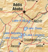
Hora-Dambal also known as Lake Zway or Dambal (Oromo: Hora Dambal, Amharic: ዟይ ሐይቅ) is one of the freshwater Rift Valley lakes of Ethiopia. It is located about 100 miles south of Addis Ababa,[1] on the border between the Oromia and Southern Nations, Nationalities, and Peoples' Region; the woredas holding the lake's shoreline are Adami Tullu and Jido Kombolcha, Dugda, and Batu Dugda. The town of Batu town lies on the lake's western shore. The lake is fed primarily by two rivers, the Meki from the west and the Katar from the east, and is drained by the Bulbula which empties into Lake Abijatta. The lake's catchment has an area of 7025 square kilometers.[2]
| Hora-Dambal | |
|---|---|
 | |
 Hora-Dambal | |
 | |
| Coordinates | 8°00′N 38°50′E |
| Basin countries | Ethiopia |
| Max. length | 31 km (19 mi) |
| Max. width | 20 km (12 mi) |
| Surface area | 440 km2 (170 sq mi) |
| Max. depth | 8.9 m (29 ft) |
| Surface elevation | 1,636 m (5,367 ft) |
| Settlements | Batu |
Hora-Dambal is 31 kilometers long and 20 km wide, with a surface area of 440 square kilometers. It has a maximum depth of 9 meters and is at an elevation of 1,636 meters.[3][4] According to the Statistical Abstract of Ethiopia for 1967/68, Lake Ziway is 25 kilometers long and 20 km wide, with a surface area of 434 square kilometers. It has a maximum depth of 4 meters and is at an elevation of 1,846 meters.[5] It contains five islands, including Debre Sina, Galila, Funduro, Tsedecha and Tulu Gudo, which is home to a monastery said to have housed the Ark of the Covenant around the ninth century.
The early 20th-century explorer Herbert Weld Blundell describes finding that "two distinct terraces of former shores rise some 80 feet above the present level, forming a ring round that nearest to the lake on the north, about 4 miles from the shore, marking a former basin." The northern shores were covered by papyrus. Weld Blundell includes in his account "a curious tradition, perhaps suggested by the apparent elevated shore," that the lake "was a kingdom 50 miles across, inhabited by seventy-eight chiefs", which disappeared in a single night.[6]
The lake is known for its population of birds and hippopotamuses. It supports a fishing industry; according to the Ethiopian Department of Fisheries and Aquaculture, 2454 tonnes of fish are landed each year, which the department estimates is 83% of its sustainable amount.[7]
Notes
- Leslau, Wolf (1999). Dambal Ethiopic Documents: Grammar and Dictionary. Wiesbaden: Otto Harrassowitz. p. xv. ISBN 3447041625.
- Robert Mepham, R. H. Hughes, and J. S. Hughes, A directory of African wetlands, (Cambridge: IUCN, UNEP and WCMC, 1992), p. 158
- "Water Resources and Irrigation Development in Ethiopia – IWMI" Archived 18 July 2011 at the Wayback Machine, Table 3. Basic hydrological data of lakes and reservoirs of Ethiopia. (Retrieved 2 July 2011)
- Google Earth
- "Climate, 2008 National Statistics (Abstract)" Archived 13 November 2010 at the Wayback Machine, Table A.2. Central Statistical Agency website (Retrieved 26 December 2009)
- H. Weld Blundell, "Exploration in the Abai Basin, Abyssinia", The Geographical Journal, 27 (1906), pp. 529–551
- "Information on Fisheries Management in the Federal Democratic Republic of Ethiopia" (report dated January, 2003)
External links
На других языках
[de] Zway (See)
Zway oder Ziway (amharisch ዝዋይ ሐይቅ) ist einer der Süßwasserseen im Großen Afrikanischen Grabenbruch in Äthiopien.- [en] Hora-Dambal
[es] Lago Ziway
El Lago Ziway o Lago Zway[1] es uno de los lagos de agua dulce del Valle del Rift en el país africano de Etiopía. Se encuentra a unos 60 kilómetros al sur de Adís Abeba, en la frontera entre las Regiones (o kililoch) de Oromia y de las Naciones, Nacionalidades y Pueblos del Sur; los woredas (distritos) que tiene costa en el lago son Adami Tullu y Jido Kombolcha, Dugda Bora, y Ziway Dugda. La ciudad de Ziway se encuentra en la orilla occidental del lago. El lago es alimentado principalmente por dos ríos, el Meki desde el oeste y el Katar desde el este, y se drena por el bulbar que desemboca en el Lago Abijatta. La cuenca del lago tiene una superficie de 7.025 kilómetros cuadrados.[fr] Lac Ziway
Le lac Ziway (ou Zway ; en oromo : Dambal) est un lac d'eau douce d'Éthiopie. Il est situé au sud-est d'Addis-Abeba, à une altitude de 1 636 m, dans la vallée du Grand Rift.[it] Lago Zuai
Il lago Zuai (o Zway o Ziway, in amarico ዝዋይ ሐይቅ) è uno dei laghi della Rift Valley dell'Etiopia. Le sue acque sono relativamente dolci e pochissimo profonde. Questo lago è diviso da due brevi cordoni di terreno dal lago Sciala.[ru] Звай (озеро)
Звай[1] (амх. ዝዋይ ሐይቅ, читается Зуай или Зыуай[2], оромо Hara Dambal, Laaqii Dambal[3]) — пресное озеро в Эфиопии, самое северное из цепочки озёр в долине Главного Эфиопского рифта[en].Другой контент может иметь иную лицензию. Перед использованием материалов сайта WikiSort.org внимательно изучите правила лицензирования конкретных элементов наполнения сайта.
WikiSort.org - проект по пересортировке и дополнению контента Википедии