geo.wikisort.org - Reservoir
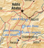
Lake Abijatta is an alkaline lake in Ethiopia. It lies in the Main Ethiopian Rift valley south of Addis Ababa, in the Abijatta-Shalla National Park.
| Lake Abijatta | |
|---|---|
 Lake Abijatta (right) and Lake Shala (left) | |
 Lake Abijatta | |
 | |
| Coordinates | 7°37′N 38°36′E |
| Basin countries | Ethiopia |
| Max. length | 17 km (11 mi) |
| Max. width | 15 km (9.3 mi) |
| Surface area | 205 km2 (79 sq mi) |
| Max. depth | 14 m (46 ft) |
| Surface elevation | 1,573 m (5,161 ft) |
Overview

According to the Statistical Abstract of Ethiopia for 1967/68, the lake is 17 kilometers long and 15 km wide, with a surface area of 205 square kilometers. It has a maximum depth of 14 meters and is at an elevation of 1,573 meters.
Along the northeastern corner of this lake are a number of hot springs, which are important both as a tourist attraction and to the local inhabitants.
Additionally, there is a soda ash operation on the shores of this lake, which produces 20,000 tons of sodium carbonate. Proven reserves at Lake Abijata, as well as the neighboring Shala and Chitu lakes, exceed 460 million tons.[1] Flamingoes are also found at the lake.
Multidisciplinary studies, including the examination of sedimentology, palynology, diatoms and organic matter have been undertaken on a 6 m core from Lake Abijata, Ethiopia. The bottom of this core has been dated at 1720 ± BP. Analyses have shown four distinct stages in lake evolution. Two transgressive phases that have been recognized can be correlated with other lake level evidence. The transgressions result from changing inputs from lowland and highland regions within the catchment. They are most probably related to changes in seasonal rainfall patterns.[2]
See also
Notes
- Current Exploration and Mining Archived 2007-04-22 at archive.today, Geological Survey of Ethiopia Web Page (accessed 26 January 2009)
- Bonnefille, R.; Robert, C.; Lezine, A. M.; Perinet, G.; Delibrias, G.; Elenga, C.; Herbin, J. P.; Tiercelin, J. J. (1986). "Palaeoenvironment of Lake Abijata, Ethiopia, during the past 2000 years". Geological Society, London, Special Publications. 25 (1): 253–265. doi:10.1144/gsl.sp.1986.025.01.21. ISSN 0305-8719. S2CID 128780442.
External links
This article about a location in the Oromia Region of Ethiopia is a stub. You can help Wikipedia by expanding it. |
На других языках
[de] Abijatta
Abijatta (amharisch አሲያታ ሐይቅ, asiyatta hayq) ist ein versalzender[1] See im Abijatta-Shalla-Nationalpark, südlich von Addis Abeba in Äthiopien.- [en] Lake Abijatta
[fr] Lac Abijatta
Le lac Abijatta est un lac de soude d'Éthiopie, situé au sud d'Addis-Abeba, dans le parc national d'Abijatta-Shalla.[ru] Абията
Абията[4][1] (амх. አሲያታ ሐይቅ)[5] — солёное озеро в Эфиопии, располагается в центре страны[4] на территории зоны Восточная Шоа региона Оромия[6]. Площадь водной поверхности составляет 205 км²[2]. Максимальная глубина достигает 9,5 метров[3].Другой контент может иметь иную лицензию. Перед использованием материалов сайта WikiSort.org внимательно изучите правила лицензирования конкретных элементов наполнения сайта.
WikiSort.org - проект по пересортировке и дополнению контента Википедии