geo.wikisort.org - Reservoir
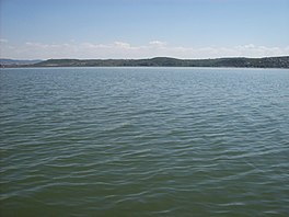
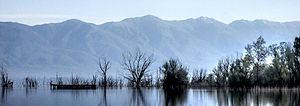
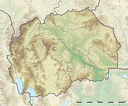
Doiran Lake (Macedonian: Дојранско Езеро, Dojransko Ezero; Greek: Λίμνη Δοϊράνη, Límni Dhoïráni), also spelled Dojran Lake[2] is a lake with an area of 43.1 km2 (16.6 sq mi)[3] shared between North Macedonia (27.3 km2, 10.5 sq mi) and Greece (15.8 km2, 6.1 sq mi).
| Dojran Lake Дојранско Езеро Λίμνη Δοϊράνη | |
|---|---|
 | |
| Location | Region of Macedonia |
| Coordinates | 41°13′N 22°45′E |
| Basin countries | Greece, North Macedonia |
| Max. length | 8.9 km (5.5 mi) |
| Max. width | 7.1 km (4.4 mi) |
| Surface area | 43.1 km2 (16.6 sq mi) |
| Max. depth | 10 m (33 ft) |
| Surface elevation | 148 m (486 ft) |
 | |
Ramsar Wetland | |
| Official name | Dojran Lake |
| Designated | 2 August 2007 |
| Reference no. | 1735[1] |
To the west is the city of Nov Dojran (Нов Дојран), to the east the village of Mouries, to the north the mountain Belasica/Beles and to the south the Greek town of Doirani. The lake has a rounded shape, a maximum depth of 10 m (33 ft) and a north-to-south length of 8.9 km (5.5 mi) and is 7.1 km (4.4 mi) at its widest, making it the third largest lake partially in North Macedonia after Lake Ohrid and Lake Prespa.
History
The lake was on the southern line of the Macedonian front during World War I, and its southern shore became the site of the various battles between allied troops and Bulgarian troops in 1916, 1917 and 1918. A monument to one of the battles and two cemeteries for Greek and British troops stand on a hill a few hundred metres south of the lake. It was designed by Sir Robert Lorimer.[4]

Ecology
The lake is shallow and eutrophic, with extensive Phragmites reedbeds.[5] Due to the overuse of the lake's water for agricultural purposes, Doiran's water nearly drained out, but the disaster was avoided after both countries took measures to replenish and sustain water levels. Frequent and heavy rainfall in later years helped restore water levels in the lake.
Important Bird Areas
North Macedonia's part of the lake has been designated an Important Bird Area (IBA) by BirdLife International because it supports populations of ferruginous ducks, Dalmatian pelicans and pygmy cormorants.[5] Greece's part of the lake is a separate but corresponding IBA.[6]
References
- "Dojran Lake". Ramsar Sites Information Service. Retrieved 25 April 2018.
- "The Return of the Glorious Past - Lake Dojran". Archived from the original on 29 October 2016. Retrieved 28 October 2016.
- "Dojran Lake". Retrieved 28 October 2016.
- Dictionary of Scottish Architects: Robert Lorimer
- "Lake Dojran". BirdLife Data Zone. BirdLife International. 2021. Retrieved 10 March 2021.
- "Lake Doïrani". BirdLife Data Zone. BirdLife International. 2021. Retrieved 10 March 2021.
External links
На других языках
[de] Dojransee
Der Dojransee (mazedonisch Дојранско Езеро .mw-parser-output .Latn{font-family:"Akzidenz Grotesk","Arial","Avant Garde Gothic","Calibri","Futura","Geneva","Gill Sans","Helvetica","Lucida Grande","Lucida Sans Unicode","Lucida Grande","Stone Sans","Tahoma","Trebuchet","Univers","Verdana"}Dojransko Ezero; griechisch Λίμνη Δοϊράνη Límni̱ Doïráni̱) ist nach Ohrid- und Prespasee der kleinste der drei großen Seen in der Balkan-Region Makedonien.- [en] Doiran Lake
[es] Lago Doiran
El lago Doiran (macedonio, Доjранско Езеро, Dojransko Ezero; griego, Λίμνη Δοϊράνη, Límni Doïráni) es un lago con una superficie de 43,1 km² compartida entre Macedonia del Norte (27,3 km²) y Macedonia Occidental dentro de la Macedonia griega (15,8 km²). Al oeste está la ciudad de Dojran, al este el pueblo de Mouries, al norte la montaña Belasica/Beles y al sur la ciudad griega de Doirani. El lago tiene una forma redondeada, una profundidad máxima de 10 m y una longitud del norte al sur de 8,9 km y tiene 7,1 km en su punto más ancho, que hacen de él el tercer lago más grande parcialmente en Macedonia del Norte después del lago Ohrid y lago Prespa.[fr] Lac de Dojran
Le lac de Dojran (en macédonien : Дојранско Езеро, en grec moderne : Λίμνη Δοϊράνη, Límni Doïráni) est un lac partagé entre la Macédoine du Nord et la Grèce.[it] Lago Dojran
Il lago Dojran è un lago situato al confine tra la Macedonia del Nord e la Grecia.[ru] Дойранское озеро
Дойра́нское о́зеро[2] (Дойран[3]; макед. Дојранско Езеро[1]) — озеро тектонического происхождения площадью 43,1 км² на границе Северной Македония (27,3 км²) (община Дойран) и Греции (15,8 км²) (Килкис, периферия Центральная Македония). На северном берегу озера находится горный массив Беласица. У озера округлая форма, максимальная глубина 10 м, длина с юга на север — 8,9 км и 7,1 км в ширину. Это третье по величине озеро в Северной Македонии после Охридского озера и озера Преспа. Озеро образовалось в четвертичный период и имеет тектонико-вулканическое происхождение. Геродот упоминает озеро как Прасиада (др.-греч. Πρασιάς)[4], также известно как Прасийское озеро (Πρασιάδα λίμνη)[5][6].Другой контент может иметь иную лицензию. Перед использованием материалов сайта WikiSort.org внимательно изучите правила лицензирования конкретных элементов наполнения сайта.
WikiSort.org - проект по пересортировке и дополнению контента Википедии

