geo.wikisort.org - Mountains
Öræfajökull (Icelandic pronunciation: [ˈœːrˌaiːvaˌjœːkʏtl̥]; 'Öræfi glacier' or 'wasteland glacier') is an ice-covered volcano in south-east Iceland. The largest active volcano and the highest peak in Iceland at 2,110 metres (6,920 ft), it lies within the Vatnajökull National Park and is covered by part of the glacier.
| Öræfajökull | |
|---|---|
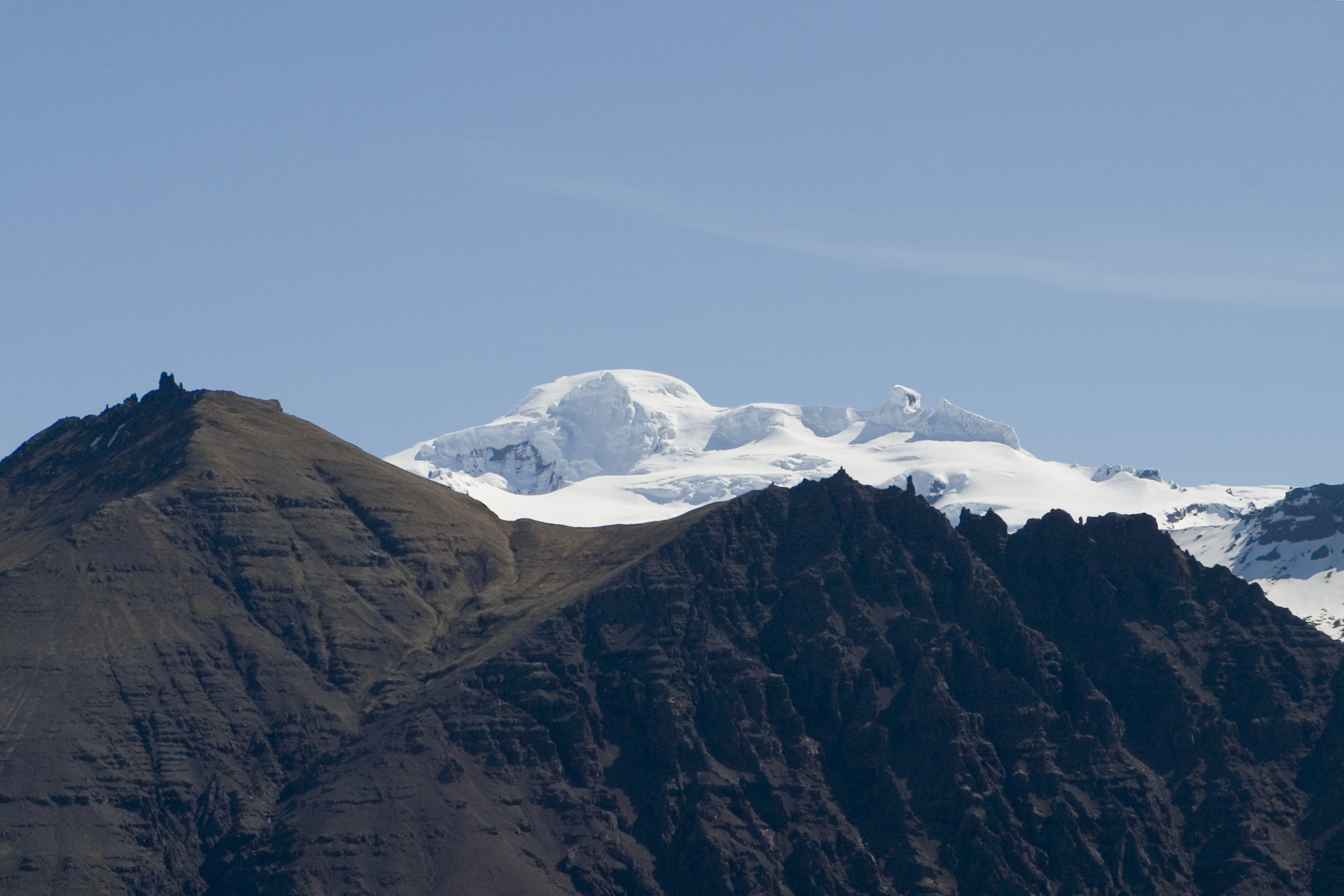
 View of Öræfajökull, showing its broad shape. | |
| Highest point | |
| Elevation | 2,109.6 metres (6,921 ft) at Hvannadalshnúkur[1] |
| Prominence | 2,109.6 metres (6,921 ft) at Hvannadalshnúkur |
| Coordinates | 64°00′N 16°39′W |
| Geography | |
| Location | Iceland |
| Parent range | Mid-Atlantic Ridge |
| Geology | |
| Age of rock | Pleistocene |
| Mountain type | Stratovolcano |
| Last eruption | 1727 to 1728 |
The original Norse settlers named the volcano Knappafellsjǫkull (Old Norse: [ˈknɑpːɑˌfelːsˌjɔkolː]; Modern Icelandic: Hnappafellsjökull [ˈn̥ahpaˌfɛlsˌjœːkʏtl̥]; 'knobs mountain glacier').[2] The current name, Öræfajökull, was eventually adopted after the 1362 eruption.
Description
Öræfajökull is located at the southern extremity of the Vatnajökull glacier and overlooking the Ring Road between Höfn and Vík. It is the largest active volcano in the country, and on the summit crater's northwestern rim is Hvannadalshnúkur, the highest peak in Iceland at 2,110 metres (6,920 ft). Geographically, Öræfajökull is considered part of Vatnajökull, and the area covered by glacier is within the boundary of Vatnajökull National Park.
Activity
Öræfajökull has erupted twice in historical times, in 1362 and 1728.
1362 eruption
In 1362, Knappafellsjökull erupted explosively, ejecting 10 cubic kilometres of tephra,[3] similar in scale to the 1991 eruption of Mount Pinatubo.[2] The wealthy district of Litlahérað was destroyed by floods, pyroclastic flows and ashfall.[3] Sailors reported pumice “in such masses that ships could hardly make their way through it.” Thick volcanic deposits obliterated farmland, and ash travelled as far as western Europe. More than 40 years passed before people again settled the area, which became known as Öræfi. The name literally means 'an area without harbour,' but it took on a meaning of 'wasteland' in Icelandic, as the 1362 eruption had drastically altered the environment around the mountain.[4] The volcano likewise took on the new name Öræfajökull.
1728 eruption
An eruption in August 1727-28 was smaller than 1362, though floods are known to have caused three fatalities when the meltwater swept their farm away.[4]
2017 activity
Increased earthquake activity in the form of small tremors ranging from a depth of 1.5–10 km beneath the summit crater, began in August 2017 according to the Icelandic Meteorological Office.
The Aviation Colour Code of the United States was raised to yellow on 17 November 2017, after the appearance of an ice cauldron inside the main crater and increased geothermal activity under the glacier.[5]
2018 activity
The seismic and geothermal activity which began in August 2017 continued into 2018, but at reduced levels. On 4 May 2018, the Icelandic Meteorological Office lowered the Aviation Colour Code to green. [6]
See also
- Geography of Iceland
- Glaciers of Iceland
- Iceland plume
- List of lakes of Iceland
- List of islands of Iceland
- List of volcanoes in Iceland
- List of rivers of Iceland
- Volcanism of Iceland
- Waterfalls of Iceland
References
- "Hvannadalshnukur". Summitpost.com. Retrieved 2013-08-09.
- "History of Öræfajökull | VolcanoCafe".
- "About Öræfajökull | Vatnajokull National Park".
- Ravilious, Kate (December 3, 2017). "Terrawatch: the reawakening of Öræfajökull" – via www.theguardian.com.
- "A new ice-cauldron in Öræfajökull volcano | News". Icelandic Meteorological office.
- Smithsonian Institution, Global Volcanism Program, Activity Archives for Öræfajökull, Retrieved Aug. 26, 2021.
External links
- Öræfajökull in the Catalogue of Icelandic Volcanoes
- Volcano Images of Europe
- Photos of Öræfajökull www.Icelandportfolio.com
- Öræfajökull at the Global Volcanism Program
- Google Earth view
- Official Website of Vatnajökull National Park

Authority control | |
|---|---|
| General |
|
| National libraries | |
На других языках
[de] Öræfajökull
Öræfajökull ([.mw-parser-output .IPA a{text-decoration:none}ˈœːraivaˌjœːkʏtl̥], isländisch für „Einöds-“ oder „Wüstengletscher“) ist der Name eines isländischen Gletschers, der Teil des Vatnajökull ist und im Südosten des Vatnajökull-Nationalparks liegt.- [en] Öræfajökull
[es] Öræfajökull
Öræfajökull es un volcán cubierto de hielo de la región de Austurland, en el sudeste de Islandia. Mide 2.109,6 msnm. Su última erupción fue en 1727 y le costó la vida a más de 1000 personas.[1] Sigue activo y es monitoreado con regularidad.[1][fr] Öræfajökull (volcan)
L'Öræfajökull est le plus grand volcan d'Islande, situé dans le sud-est du pays. Il est constitué d'une caldeira occupée par le glacier Öræfajökull, l'extrémité méridionale du Vatnajökull, la plus grande calotte glaciaire d'Islande. L'un des rebords de cette caldeira, le Hvannadalshnjúkur, constitue le point culminant du pays.[it] Öræfajökull
Öræfajökull è un vulcano situato in Islanda. Il nome significa letteralmente ghiacciaio privo di porto, ma nella lingua islandese ha assunto il significato di ghiacciaio deserto.[ru] Эрайвайёкюдль
Э́райвайё̀кюдль (исл. Öræfajökull) — покрытый льдом вулкан в юго-восточной части Исландии. Является крупнейшим действующим вулканом на острове, на его северо-западном краю находится высочайшая точка страны — пик Хваннадальсхнукюр. Географически относится к крупнейшему исландскому леднику Ватнайёкюдль. Вулкан находится в его юго-западной части, которая расположена на территории национального парка Скафтафедль.Другой контент может иметь иную лицензию. Перед использованием материалов сайта WikiSort.org внимательно изучите правила лицензирования конкретных элементов наполнения сайта.
WikiSort.org - проект по пересортировке и дополнению контента Википедии