geo.wikisort.org - Mountains
The Yablonoi Mountains or Yablonovy Mountains (Russian: Яблоновый хребет, Buryat: Яабланай шэлэ нуруу, Yaablanai shele nuruu; Mongolian: Яблоны нуруу, Yablony nuruu) are a mountain range, in Transbaikal (mainly in Zabaykalsky Krai), Siberia, Russia. The range is sparsely inhabited with most settlements engaged in mining. The area is especially rich in tin. The city of Chita lies between the Yablonoi Mountains to the west and the Chersky Range to the east.[1]
This article needs additional citations for verification. (April 2013) |
| Yablonoi Mountains | |
|---|---|
| Яблоновый хребет / Яабланай шэлэ нуруу | |
 Topographical map of Russia with the Yablonoi Mountains on the right side. | |
| Highest point | |
| Peak | Kontalaksky Golets |
| Elevation | 2,519 m (8,264 ft) |
| Coordinates | 53°54′47″N 115°41′35″E |
| Dimensions | |
| Length | 650 km (400 mi) NE/SW |
| Width | 70 km (43 mi) NW/SE |
| Geography | |
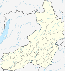 Location in Transbaikalia, Russia | |
| Country | Russia |
| Federal subject | Transbaikal Krai |
| Range coordinates | 52°03′N 113°35′E |
| Parent range | South Siberian System |
| Borders on | Mongolia |
| Geology | |
| Age of rock | Paleozoic and Permian |
| Type of rock | Granites, crystalline slates, and sandstones |
| Climbing | |
| Easiest route | From Chita |
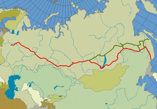
The Trans-Siberian Railroad passes the mountains at Chita and runs parallel to the range before going through a tunnel to bypass the heights.[2]
Geography
The Yablonoi Mountains stretch for about 650 kilometres (400 mi) in a northeast–southwest direction. They rise mostly in the western part of the Zabaikalsky Krai, with a small section in the southeastern part of Buryatia. The width of the range varies between 20 kilometres (12 mi) and 120 kilometres (75 mi). The Vitim Plateau lies to the north and the Borshchovochny Range to the east of the range. The tallest peak is Kontalaksky Golets, a "golets"-type of mountain with a bald peak, at 1,706 metres (5,597 ft) above sea level.[3]
The Vitim River flows at the northwestern edge of the range, together with its tributaries the Konda and the Karenga, which flow northeastwards. To the southwest flow the Khilok and the Ingoda and in the northeast the Olyokma.[4]
 |
Flora
The slopes of the Yablonoviy Range are covered with larch and occasional fir and silver fir taiga. Pine forests are quite common on the southern slopes of the range. Peaks higher than 1,200 - 1,400 metres are covered with mountain tundra with bare summits (golets) at higher altitudes.
See also
References
- Google Earth
- "Yablonovy Range". Farlex, Inc. Retrieved 30 January 2013.
- 1:200.000, Bl. N-50-XX, 1992 edn. - Topographic map
- "Chita". visitchita.ru. Retrieved 21 August 2015.
External links
- The Permian of the Transbaikal region, eastern Russia: Biostratigraphy, correlation and biogeography
- Physiogeography of the Russian Far East
This Asia mountain, mountain range, or peak related article is a stub. You can help Wikipedia by expanding it. |
This Russian location article is a stub. You can help Wikipedia by expanding it. |
На других языках
[de] Jablonowygebirge
Das Jablonowygebirge (russisch Яблоновый хребет, wiss. Transliteration Jablonovyj chrebet) in Sibirien, Russland (Asien) ist ein bis 1706 m[1] hohes Mittelgebirge der Südsibirischen Gebirge.- [en] Yablonoi Mountains
[es] Montes Yáblonoi
Los montes Yáblonovy (o Yáblonoi o Iáblonovy) (en ruso, Яблоновый хребет, montes de los manzanos) son una cadena montañosa localizada al sureste de Siberia en Rusia.[fr] Monts Iablonovy
Les monts Iablonovy (en russe : Яблоновый хребет) sont un massif montagneux situé au sud-est de la Sibérie en Russie. Le massif se situe au nord-est de la Mongolie et à l'est du lac Baïkal. Il s'étend du sud-ouest, au niveau de la frontière russo-mongole, vers le nord-est où il rejoint les monts Stanovoï, et fait face aux monts Baïkal qui dominent l'autre rive du lac. Il forme la ligne de partage des eaux entre le bassin de l’océan Arctique et celui de l’océan Pacifique.[it] Monti Jablonovyj
I monti Jablonovyj (russo Яблоновый хребет, Jablonovyj chrebet) sono una catena montuosa della Siberia Orientale meridionale (Territorio della Transbajkalia).[ru] Яблоновый хребет
Я́блоновый хребе́т (бур. Ябалан шэлэ, от глагола ябаха — «идти», в значении «проходимый, проезжий перевал»[1].) — горный хребет с преобладанием среднегорного рельефа в центральной части Забайкалья, главным образом на территории Забайкальского края.Другой контент может иметь иную лицензию. Перед использованием материалов сайта WikiSort.org внимательно изучите правила лицензирования конкретных элементов наполнения сайта.
WikiSort.org - проект по пересортировке и дополнению контента Википедии