geo.wikisort.org - Mountains
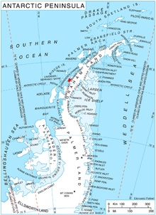
Waldeck-Rousseau Peak (66°9′S 65°38′W) is a conspicuous monolith 3 nautical miles (6 km) east-northeast of Cape Evensen on Stresher Peninsula on Graham Coast, Antarctic Peninsula. The French Antarctic Expedition (1903–05) under Jean-Baptiste Charcot charted a cape in this area which they named for French statesman Pierre Waldeck-Rousseau. On re-exploring this area, the French Antarctic Expedition (1908–10) under Charcot sighted the feature from Pendleton Strait, 25 nautical miles (46 km) distant, and charted it as an island near the coast. Correlating its work with that of Charcot, the British Graham Land Expedition (BGLE) under John Rymill charted this portion of the coast by land and from the air in 1935. Waldeck-Rousseau Peak as here applied is in accord with the interpretation of the BGLE.
![]() This article incorporates public domain material from the United States Geological Survey document: "Waldeck-Rousseau Peak". (content from the Geographic Names Information System)
This article incorporates public domain material from the United States Geological Survey document: "Waldeck-Rousseau Peak". (content from the Geographic Names Information System)
This Loubet Coast location article is a stub. You can help Wikipedia by expanding it. |
На других языках
[de] Waldeck-Rousseau Peak
Der Waldeck-Rousseau Peak (im Vereinigten Königreich Waldeck Peak) ist ein monolithischer, rund 1200 m hoher und markanter Berg an der Graham-Küste des Grahamlands im Norden der Antarktischen Halbinsel. Er ragt 5 km ostnordöstlich des Kap Evensen auf.- [en] Waldeck-Rousseau Peak
Другой контент может иметь иную лицензию. Перед использованием материалов сайта WikiSort.org внимательно изучите правила лицензирования конкретных элементов наполнения сайта.
WikiSort.org - проект по пересортировке и дополнению контента Википедии