geo.wikisort.org - Coast
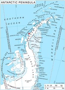
Stresher Peninsula (Bulgarian: полуостров Стрешер, romanized: poluostrov Stresher, IPA: [poɫuˈɔstrof ˈstrɛʃɛr]; 66°16′10″S 65°26′40″W) is the predominantly ice-covered rectangular peninsula 30 km wide and projecting 24 km northwestwards from Graham Land, Antarctic Peninsula. It is bounded by Holtedahl Bay to the northeast, Auvert Bay to the northwest and Darbel Bay to the southwest. Its west extremity Cape Bellue separates Graham Coast to the northeast from Loubet Coast to the southwest. Lawson Peak is a peak 3.5 nautical miles (6 km) southeast of Cape Evensen.
The feature is named after Stresher Peak in the Balkan Mountains, Bulgaria.
Maps
- British Antarctic Territory. Scale 1:200000 topographic map. DOS 610 Series, Sheet W 66 64. Directorate of Overseas Surveys, Tolworth, UK, 1976.
- Antarctic Digital Database (ADD). Scale 1:250000 topographic map of Antarctica. Scientific Committee on Antarctic Research (SCAR), 1993–2016.
See also
- Owlshead Peak
- Wooden Peak
- Workman Rocks
References
- Stresher Peninsula. SCAR Composite Antarctic Gazetteer.
- Bulgarian Antarctic Gazetteer. Antarctic Place-names Commission. (details in Bulgarian, basic data in English)
External links
- Stresher Peninsula. Copernix satellite image
This article includes information from the Antarctic Place-names Commission of Bulgaria which is used with permission.
This Graham Coast location article is a stub. You can help Wikipedia by expanding it. |
На других языках
[de] Strescher-Halbinsel
Die Strescher-Halbinsel (bulgarisch полуостров Стрешер .mw-parser-output .Latn{font-family:"Akzidenz Grotesk","Arial","Avant Garde Gothic","Calibri","Futura","Geneva","Gill Sans","Helvetica","Lucida Grande","Lucida Sans Unicode","Lucida Grande","Stone Sans","Tahoma","Trebuchet","Univers","Verdana"}poluostrow Strescher) ist eine 24 km lange, 30 km breite und größtenteils vereiste Halbinsel im Westen des Grahamlands auf der Antarktischen Halbinsel. Sie liegt zwischen der Holtedahl Bay im Nordosten, der Auvert Bay im Nordwesten und der Darbel Bay im Südwesten. Ihr westlicher Ausläufer, das Kap Bellue trennt die Graham-Küste im Nordosten von der Loubet-Küste im Südwesten.- [en] Stresher Peninsula
Другой контент может иметь иную лицензию. Перед использованием материалов сайта WikiSort.org внимательно изучите правила лицензирования конкретных элементов наполнения сайта.
WikiSort.org - проект по пересортировке и дополнению контента Википедии