geo.wikisort.org - Mountains
Triple Divide Peak (8,025 feet or 2,446 metres) is located in the Lewis Range, part of the Rocky Mountains in North America. The peak is a feature of Glacier National Park in the state of Montana in the United States.[3] The summit of the peak, the hydrological apex of the North American continent, is the point where two of the principal continental divides in North America converge, the Continental Divide of the Americas and the Northern or Laurentian Divide.
| Triple Divide Peak | |
|---|---|
 Triple Divide Peak, east aspect | |
| Highest point | |
| Elevation | 8,025 ft (2,446 m)[1] |
| Prominence | 180 ft (55 m)[1] |
| Parent peak | Norris Mountain[1] |
| Listing | Mountains in Flathead County Mountains in Glacier County |
| Coordinates | 48°34′23″N 113°31′00″W[2] |
| Geography | |
 Triple Divide Peak Location in Montana  Triple Divide Peak Location in the United States | |
| Location | Flathead County, Montana, Glacier County, Montana, U.S. |
| Parent range | Lewis Range |
| Topo map | USGS Mount Stimson, MT |

Hydrography
Water that falls at the summit can flow either to the Pacific, Atlantic, or Arctic oceans (when Hudson Bay is considered an Arctic tributary). The International Hydrographic Organization (in its current unapproved working edition only[4] of Limits of Oceans and Seas) defines the Hudson Bay, with its outlet extending from 62.5 to 66.5 degrees north (just a few miles south of the Arctic Circle) as being part of the Arctic Ocean, specifically "Arctic Ocean Subdivision 9.11."
Discounting Antarctica and its ice sheets, only one other continent (Asia) borders three oceans, but the inward-draining endorheic basin area of Central Asia from western China to the Aral and Caspian Seas is so vast that any Arctic and Indian Ocean tributaries are never within proximity of each other.[5] Thus, North America's status of having a single location draining into three oceans is unique in the world. (However, some sources consider Hudson Bay to be part of the Atlantic, making Snow Dome – partially in Jasper National Park, on the border of the provinces of Alberta and British Columbia, Canada – to be the continent's sole hydrological apex.)[6][7][8]
Rainfall on the southwestern side of the peak enters Pacific Creek, which in turn enters Nyack Creek, the Middle Fork of the Flathead River, the Flathead River through Flathead Lake, the Clark Fork River into Pend Oreille Lake, the Pend Oreille River, and the Columbia River which empties into the Pacific near Astoria, Oregon.
The northern slope of the mountain sheds water into Hudson Bay Creek, which then drains into Medicine Owl Creek and Red Eagle Creek. It then empties into Saint Mary Lake, which feeds the St. Mary River, which in turn flows into the Oldman River, the South Saskatchewan River, the Saskatchewan River, and the Lake Winnipeg system, drained by the Nelson River which empties into Hudson Bay.
Moisture on the southeastern slopes feeds into Atlantic Creek, which in turn enters the North Fork of Cut Bank Creek, Cut Bank Creek, the Marias River, and the Missouri River which joins the Mississippi River before emptying into the Atlantic's Gulf of Mexico near New Orleans.
Geology
The Lewis Range was formed in the Lewis Overthrust, some 170 million years ago, when an enormous slab of Precambrian rock faulted and slid over younger rocks from the Cretaceous period.
Gallery
 The small Triple Divide Peak (centered) with Norris Mountain on left and Split Mountain to right.
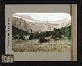 Triple Divide Peak upper right
(Razoredge Mountain upper left)![Looking south from Triple Divide Mountain, 1917.Bad Marriage Mountain (left of center) and Medicine Grizzly Peak right[9]](//upload.wikimedia.org/wikipedia/commons/thumb/e/e8/ViewFromTripleDividePeak%28south%29.JPG/120px-ViewFromTripleDividePeak%28south%29.JPG) Looking south from Triple Divide Mountain, 1917.
Looking south from Triple Divide Mountain, 1917.
Bad Marriage Mountain (left of center) and Medicine Grizzly Peak right[9]


![Looking south from Triple Divide Mountain, 1917.Bad Marriage Mountain (left of center) and Medicine Grizzly Peak right[9]](http://upload.wikimedia.org/wikipedia/commons/e/e8/ViewFromTripleDividePeak%28south%29.JPG)
See also
References
- "Triple Divide Peak, Montana". Peakbagger.com. Retrieved 2010-08-22.
- "Triple Divide Peak". Geographic Names Information System. United States Geological Survey, United States Department of the Interior. Retrieved 2010-08-22.
- "Triple Divide Peak, Montana" (Map). TopoQuest (USGS Quad). Retrieved 2010-08-22.
- "IHO Publication S-23 Limits of Oceans and Seas; Chapter 9: Arctic Ocean". International Hydrographic Organization. 2002. Retrieved 2017-07-01.
- "Ocean Triple Divide Points". Peakbagger.com. Retrieved 2017-07-01.
- Sanford, Robert W. (2010). Our World's Heritage: Creating a Culture Worthy of Place in Canada's Western Mountain Parks. Athabasca University Press. p. 160. ISBN 978-1-897425-57-2.
- Canada's watersheds, The Canadian Atlas Online
- The North Saskatchewan River Archived 2010-05-26 at the Wayback Machine, Great Canadian Rivers
- Holtz, Mathilde Edith; Bemis, Katharine Isabel (1917). Glacier National Park: Its Trails and Treasures (PDF). New York: George H. Doran.
External links
На других языках
[de] Triple Divide Peak
Der Triple Divide Peak ist ein Gipfel in den Rocky Mountains im US-Bundesstaat Montana nahe der Grenze zu Kanada. Er stellt den Wasserscheidepunkt dar, an dem sich die Einzugsgebiete des Atlantischen Ozeans über das Missouri-Mississippi-Flusssystem und den Golf von Mexiko, des Pazifischen Ozeans über den Columbia River und des Arktischen Ozeans über den Saskatchewan River und die Hudson Bay berühren. Er stellt damit den Endpunkt der traditionellen nordamerikanischen kontinentalen Wasserscheide dar und ist weltweit der einzige Punkt, an dem sich die Wasserscheiden dreier verschiedener Weltmeere treffen.- [en] Triple Divide Peak (Montana)
[es] Pico Triple Divide (Montana)
El pico Triple Divide (en inglés, Triple Divide Peak,[1] lit., 'pico [de la] Triple Divisoria [hidrográfica]'), es un pico estadounidense que se encuentra en la cordillera Lewis, parte de las Montañas Rocosas. Tiene un altitud de 2446 msnm[2] y una escasa prominencia de solo 55 m.[2] El pico es un accidente del parque nacional de los Glaciares en el estado de Montana.[3] La cumbre del pico, el vértice hidrográfico de la América del Norte continental, es el punto en el que convergen dos de las principales divisorias continentales de América del Norte, la divisoria continental de las Américas y la divisoria Laurentiana, siendo un triple punto oceánico, el único existente en el mundo.[fr] Pic Triple Divide (Montana)
Le pic Triple Divide, en anglais Triple Divide Peak, est une montagne culminant à 2 444 m d'altitude dans le parc national de Glacier dans l'État du Montana aux États-Unis. Son sommet est le tripoint entre les bassins hydrographiques nord-américains de l'océan Pacifique, de l'océan Atlantique et de l'océan Arctique. Les eaux s'écoulant sur ses versants nord et nord-est se dirigent vers l'océan Arctique, les eaux qui s'écoulent du nord-ouest au sud se dirigent vers l'océan Pacifique tandis que les eaux qui se déversent au sud-est partent vers le golfe du Mexique.[ru] Трипл-Дивайд-Пик
Трипл-Дивайд-Пик (англ. Triple Divide Peak, букв. Пик Трёх Водоразделов) — гора в национальном парке Глейшер, в штате Монтана, США. Является важной гидрологической вершиной: в этой точке встречаются главный водораздел (континентальный водораздел Северной Америки) и водораздел Лаврентийской возвышенности.Другой контент может иметь иную лицензию. Перед использованием материалов сайта WikiSort.org внимательно изучите правила лицензирования конкретных элементов наполнения сайта.
WikiSort.org - проект по пересортировке и дополнению контента Википедии