geo.wikisort.org - River
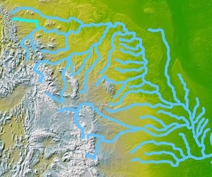
The Marias River is a tributary of the Missouri River, approximately 210 mi (338 km) long, in the U.S. state of Montana. It is formed in Glacier County, in northwestern Montana, by the confluence of the Cut Bank Creek and the Two Medicine River. It flows east, through Lake Elwell, formed by the Tiber Dam, then southeast, receiving the Teton River at Loma, 2 mi. (3.2 km) above its confluence with the Missouri.
| Marias River | |
|---|---|
 The Marias River | |
| Location | |
| County | Chouteau, Hill, Liberty, Toole, Pondera and Glacier County, Montana |
| Physical characteristics | |
| Source | |
| • coordinates | 48°29′12″N 112°13′41″W[1] |
| Mouth | |
• coordinates | 47°55′46″N 110°28′21″W[1] |
• elevation | 2,559 feet (780 m)[1] |
| Discharge | |
| • location | near Loma (includes Teton River) |
| • average | 1,043 cu ft/s (29.5 m3/s)[2] |
| Basin features | |
| River system | Missouri River |
The river was explored in 1805 by the Lewis and Clark Expedition. Some of the men on the expedition mistook it for the main branch of the Missouri until their subsequent discovery of the Great Falls of the Missouri near Great Falls, Montana. The river was named by Meriwether Lewis after his cousin, Maria Wood. Lewis led a small detachment of men to further explore the Marias River on the Expedition's return trip in 1806 to determine if the river ventured north above the Canada border, and he killed a young Blackfeet warrior trying to steal horses and a gun from the small detachment.
The river was the scene of the 1870 Marias Massacre.[3]
The Marias is a Class I river from Tiber Dam to its confluence with the Missouri River for public access for recreational purposes.[4]
The Montana Watershed Coordination Council is an advocate for the river.[5]
The Marias River Bridge was listed on the National Register of Historic Places in 2012.
See also
- Montana Stream Access Law
- List of rivers of Montana
External links
Notes
- "Marias River". Geographic Names Information System. United States Geological Survey.
- "USGS Surface Water data for Montana: USGS Surface-Water Annual Statistics".
- "Witnesses to Carnage-The 1870 Marias Massacre in Montana". Retrieved 2010-05-20.
- Stream Access in Montana Archived 2009-03-10 at the Wayback Machine
- "Montana Watershed Coordination Council". Retrieved 2010-05-20.
Helena (capital) | ||
| Topics |
|  Seal of Montana |
| Society |
| |
| Regions |
| |
| Largest cities | ||
| Counties |
| |
Authority control | |
|---|---|
| General |
|
| National libraries | |
На других языках
[de] Marias River
Der Marias River ist ein linker Nebenfluss des Missouri River im US-Bundesstaat Montana.- [en] Marias River
[es] Río Marías
El río Marias (en inglés: Marias River) es un afluente del río Misuri de aproximadamente 338 km de longitud. Discurre por el estado de Montana, en Estados Unidos. El río nace por la confluencia del arroyo Cut Bank y el río Two Medicine, en el condado de Glacier, en la Reserva India de los Blackfeet, al noroeste del estado. El río discurre hacia el Este, a través del lago Elwell y, más tarde, hacia el Sureste, donde recibe las aguas del río Tetón. El río atraviesa el parque nacional de los Glaciares.Другой контент может иметь иную лицензию. Перед использованием материалов сайта WikiSort.org внимательно изучите правила лицензирования конкретных элементов наполнения сайта.
WikiSort.org - проект по пересортировке и дополнению контента Википедии