geo.wikisort.org - Mountains
The Lewis Range is a mountain range located in the Rocky Mountains of northern Montana, United States and extreme southern Alberta, Canada. It was formed as a result of the Lewis Overthrust, a geologic thrust fault resulted in the overlying of younger Cretaceous rocks by older Proterozoic rocks. The range is located within Waterton Lakes National Park in Alberta, Canada and Glacier National Park and the Bob Marshall Wilderness Complex in Montana, United States. The highest peak is Mount Cleveland at 10,466 ft (3,190 m).
This article needs additional citations for verification. (January 2016) |
| Lewis Range | |
|---|---|
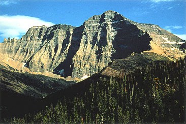 Mount Cleveland is the highest peak in the Lewis Range | |
| Highest point | |
| Peak | Mount Cleveland |
| Elevation | 10,466 ft (3,190 m) |
| Coordinates | 48°55′29″N 113°50′53″W |
| Geography | |
 Lewis Range Location in Montana  Lewis Range Location in the United States | |
| Countries | United States and Canada |
| Province/State | Montana and Alberta |
| Parent range | Rocky Mountains |
| Geology | |
| Orogeny | Lewis Overthrust |
Geology
Formed by the Lewis Overthrust beginning 170 million years ago, an enormous slab of Precambrian rocks 3 miles (4.8 km) thick, 50 miles (80 km) wide and 160 miles (260 km) long faulted and slid over newer rocks of the Cretaceous period. In this relatively rare occurrence, older rocks are now positioned above newer ones.[citation needed]
Geography
The Lewis Range is within Waterton Lakes National Park in Canada, and in Glacier National Park and the Bob Marshall Wilderness Complex located in Flathead and Lewis and Clark National Forests in Montana. The Continental Divide spans much of the uppermost sections of the range. Major peaks in the range include Mount Cleveland (10,466 ft/3,185 m), which is the highest peak in the range and in Glacier National Park. Other prominent peaks include Mount Stimson (10,142 ft/3,091 m), Mount Jackson (10,052 ft/3,064 m), Mount Siyeh (10,014 ft/3,052 m), Going to the Sun Mountain, (9,642 ft/2,939 m) and the isolated Chief Mountain (9,080 ft/2,768 m). The Chinese wall in the Bob Marshall Wilderness is a 1,000 foot (304 m) high feature that runs for 40 miles (64 km). Major passes include Marias Pass and Logan Pass which bisects Glacier National Park east to west.
See also
- Mountains and mountain ranges of Glacier National Park (U.S.)
- List of mountain ranges in Montana
External links
- Glacier National Park. "Lewis Overthrust Fault". Geology. Retrieved 2006-05-08.
 Media related to Lewis Range at Wikimedia Commons
Helena (capital) | ||
| Topics |
|  Seal of Montana |
| Society |
| |
| Regions |
| |
| Largest cities | ||
| Counties |
| |
| Authority control: National libraries |
|---|
На других языках
- [en] Lewis Range
[fr] Chaînon Lewis
Le chaînon Lewis est une chaîne de montagnes des montagnes Rocheuses située au nord du Montana aux États-Unis et au sud de l’Alberta au Canada.[ru] Льюис (хребет)
Льюис — горный хребет длиной 260 км, расположенный в Скалистых горах на территории северной части американского штата Монтана и южной части канадской провинции Альберта. Возник в результате надвига Льюиса, начавшейся около 170 млн лет назад. Массивные докембрийские отложения толщиной 5 км, шириной 80 и длиной 260 км располагаются поверх отложений мелового периода.Другой контент может иметь иную лицензию. Перед использованием материалов сайта WikiSort.org внимательно изучите правила лицензирования конкретных элементов наполнения сайта.
WikiSort.org - проект по пересортировке и дополнению контента Википедии