geo.wikisort.org - Mountains
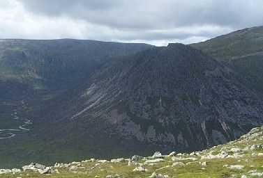
The Devil's Point (Scottish Gaelic: Bod an Deamhain) is a mountain in the Cairngorms of Scotland, lying to the west of the Lairig Ghru pass. The Gaelic name means "Penis of the Demon". The English name is a result of a visit to the area by Queen Victoria. She asked her local ghillie, John Brown, to translate the name; to avoid embarrassment he gave a euphemistic answer.[2]

| The Devil's Point | |
|---|---|
| Bod an Deamhain | |
 | |
| Highest point | |
| Elevation | 1,004 m (3,294 ft)[1] |
| Prominence | c. 89 m |
| Parent peak | Cairn Toul |
| Listing | Munro |
| Naming | |
| English translation | Penis of the demon |
| Language of name | Scottish Gaelic |
| Pronunciation | Scottish Gaelic: [ˈpɔt̪ əɲ ˈtʲãũ.ɪɲ] |
| Geography | |
| Location | Cairngorms, Scotland |
| OS grid | NN976951 |
| Topo map | OS Landranger 43 |
Although The Devil's Point is strikingly distinct when seen from the south, it is a subsidiary peak of Cairn Toul, the summit of which lies some three kilometres (two miles) to the north. The easiest route is to follow the path leading up the Coire Odhar from Corrour Bothy, on the eastern side of the mountain. To reach the bothy requires a long walk in; the most usual route is to follow the Lairig Ghru from Linn of Dee, a distance of some 12 km (7+1⁄2 mi).
The Devil's Point is often climbed along with Cairn Toul. Sgòr an Lochain Uaine, which lies to the north of Cairn Toul is sometimes called The Angel's Peak, in contrast to The Devil's Point.[3][4]
References
- "walkhighlands The Devil's Point". walkhighlands.co.uk. 2013. Retrieved 15 October 2013.
- McNeish, Cameron. The Munros: Scotland's Highest Mountains. Lomond Books, 1998, p.125
- Drummond, Peter (2010). Scottish hill names: their origin and meaning. Scottish Mountaineering Trust. pp. 123, 130. ISBN 9780907521952.
- "Macdui horizons" (PDF). Clac Dian: the newsletter of the Cairngorm Club: 5. June 2010.
See also
- The Devil's Arse, Derbyshire, England
Munros of Scotland: the Cairngorms | |||
|---|---|---|---|
 |  | ||
| |||
На других языках
[de] The Devil’s Point
The Devil’s Point (dt.: „Spitze des Teufels“, gäl.: Bod an Deamhain „Der Penis des Teufels“) ist ein 1004 m hoher, als Munro klassifizierter Berg in den Cairngorms, einem Gebirgsmassiv der schottischen Highlands.- [en] The Devil's Point
[ru] Те-Девилс-Пойнт
Те-Де́вилс-По́йнт (англ. The Devil's Point, гэльск. Bod an Deamhain) — холм в округе Абердиншир (Шотландия), входит в список Мунро шотландских вершин выше 3000 футов. Высота вершины над уровнем моря — 1004 метра, относительная высота — 89 метров. Входит в состав горного хребта Кернгормс[en]. Родительская гора — Кэрн-Тул[en] (1291 м).Другой контент может иметь иную лицензию. Перед использованием материалов сайта WikiSort.org внимательно изучите правила лицензирования конкретных элементов наполнения сайта.
WikiSort.org - проект по пересортировке и дополнению контента Википедии