geo.wikisort.org - Mountains
Cairn Toul (Scottish Gaelic: Càrn an t-Sabhail, 'hill of the barn')[3] is the fourth-highest mountain in Scotland and all of the British Isles, after Ben Nevis, Ben Macdui and Braeriach. The summit is 1,291 metres (4,236 feet) above sea level. It is in the western massif of the Cairngorms, linked by a bealach at about 1125 m to Braeriach. The mountain towers above the Lairig Ghru pass.
| Cairn Toul | |
|---|---|
| Càrn an t-Sabhail | |
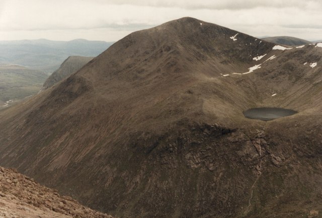 Cairn Toul from Braeriach, with Lochan Uaine | |
| Highest point | |
| Elevation | 1,291 m (4,236 ft)[1] |
| Prominence | c. 166 m |
| Parent peak | Braeriach |
| Isolation | 2.85 km (1.77 miles) [2] |
| Listing | Munro, Marilyn |
| Naming | |
| English translation | hill of the barn |
| Language of name | Gaelic |
| Pronunciation | Scottish Gaelic: [ˈkʰaːrˠn ən ˈt̪o.əl̪ˠ] |
| Geography | |
| Location | Cairngorms, Scotland |
| OS grid | NN963972 |
| Topo map | OS Landrangers 36, 43 |
Cairn Toul is often climbed together with other peaks. From the south, it may be climbed with The Devil's Point, which lies about 2.5 kilometres south-southeast. Alternatively, it may be climbed from the north, including Braeriach and Sgor an Lochain Uaine. Both routes are long days by Scottish standards: around 15 km (plus return) regardless of whether one starts from Coire Cas above Speyside, or Linn of Dee to the south. The mountain may also be climbed from the west, starting from Achlean in Glen Feshie. This provides for a slighter shorter route (around 27 km for the round trip), though the walker must negotiate a large expanse of undulating boggy plateau in order to reach the Breariach-Cairn Toul massif.
There is a bothy, Corrour, at the point below Cairn Toul in the defile of the Lairig Ghru.
See also
References
- "Cairn Toul (Càrn an t-Sabhail)". Hill Bagging - the online version of the Database of British and Irish Hills (DoBIH). 2019. Retrieved 20 June 2019.
- "Cairn Toul isolation".
- "Cairn Toul". Ainmean-Àite na h-Alba: Gaelic Place-Names of Scotland.
Munros of Scotland: the Cairngorms | |||
|---|---|---|---|
 |  | ||
| |||
На других языках
[de] Cairn Toul
Der Cairn Toul (gäl. Càrn an t-Sabhail, dt Scheunenhügel) ist mit 1291 m der vierthöchste Berg Schottlands und Großbritanniens, höher sind nur Ben Nevis, Ben Macdui und Braeriach. Außer dem Ben Nevis liegen diese Berge alle im Naturschutzgebiet Mar Lodge Estate. Der Gipfel ist der zweithöchste Punkt im westlichen Abschnitt der Cairngorms, und über einen Bergsattel auf 1125 m mit dem Braeriach verbunden. Der Berg erhebt sich westlich des Lairig Ghru Passes.- [en] Cairn Toul
[fr] Cairn Toul
Cairn Toul (du gaélique Càrn an t-Sabhail, « colline de la grange ») est le quatrième sommet le plus élevé d'Écosse, derrière le Ben Nevis, le Ben Macdhui et le Braeriach. C'est le second plus haut sommet dans l'Ouest du massif de Cairngorms, lié par un col à environ 1 125 m d'altitude à Braeriach.Другой контент может иметь иную лицензию. Перед использованием материалов сайта WikiSort.org внимательно изучите правила лицензирования конкретных элементов наполнения сайта.
WikiSort.org - проект по пересортировке и дополнению контента Википедии