geo.wikisort.org - Mountains
Stribog Mountains (Bulgarian: планина Стрибог, ‘Planina Stribog’ \pla-ni-'na 'stri-bog\) is the principal mountain system of Brabant Island in the Palmer Archipelago, Antarctica rising to 2498 m[1] (Mount Parry). The feature is 40 km long in north-south direction and 15 km wide, connected to Stavertsi Ridge on the northeast by Viamata Saddle, to Avroleva Heights on the east by Doriones Saddle, and to Solvay Mountains on the south by Aluzore Gap. It is heavily glaciated, with steeper and partly ice-free west slopes.
The mountains are named after the Slavic god of wind, ice and cold Stribog.
Location
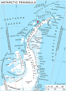
Stribog Mountains are centred at 64°12′00″S 62°20′00″W. British mapping in 1980 and 2008.
Maps
- Antarctic Digital Database (ADD). Scale 1:250000 topographic map of Antarctica. Scientific Committee on Antarctic Research (SCAR). Since 1993, regularly upgraded and updated.
- British Antarctic Territory. Scale 1:200000 topographic map. DOS 610 Series, Sheet W 64 62. Directorate of Overseas Surveys, Tolworth, UK, 1980.
- Brabant Island to Argentine Islands. Scale 1:250000 topographic map. British Antarctic Survey, 2008.
Notes
- Reference Elevation Model of Antarctica. Polar Geospatial Center. University of Minnesota, 2019
References
- Bulgarian Antarctic Gazetteer. Antarctic Place-names Commission. (details in Bulgarian, basic data in English)
- Stribog Mountains. SCAR Composite Antarctic Gazetteer.
External links
- Stribog Mountains. Adjusted Copernix satellite image

This article includes information from the Antarctic Place-names Commission of Bulgaria which is used with permission.
This Brabant Island location article is a stub. You can help Wikipedia by expanding it. |
На других языках
[de] Stribog Mountains
Die Stribog Mountains (englisch; bulgarisch планина Стрибог .mw-parser-output .Latn{font-family:"Akzidenz Grotesk","Arial","Avant Garde Gothic","Calibri","Futura","Geneva","Gill Sans","Helvetica","Lucida Grande","Lucida Sans Unicode","Lucida Grande","Stone Sans","Tahoma","Trebuchet","Univers","Verdana"}planina Stribog) sind das größte Gebirge auf der Brabant-Insel im Palmer-Archipel westlich der Antarktischen Halbinsel. In Nord-Süd-Ausrichtung ist es 40 km lang, 15 km breit und mit dem Stavertsi Ridge nach Nordosten über den Viamata Saddle, mit den Avroleva Heights nach Osten über den Doriones Saddle und mit den Solvay Mountains nach Süden über das Aluzore Gap verbunden. Das Gebirge ist stark vergletschert, seine Westhänge sind steil und teilweise unvereist.- [en] Stribog Mountains
[it] Montagne di Stribog
Le montagne di Stribog sono una catena montuosa situata sull'isola Brabant, una delle isole dell'arcipelago Palmer, al largo della costa nord-occidentale della Terra di Graham, in Antartide. La catena è orientata in direzione nord-sud, raggiungendo una lunghezza di 40 km e una larghezza di 15 ed estendendosi dalla cresta Stavertsi, a nord-est, a cui è connessa dalla sella Viamata, alle cime Avroleva, a cui è unita dalla sella Doriones, alle montagne di Solvay, da cui la separa il passo Aluzore. Dai versanti delle montagne di Stribog, il cui punto più alto è costituito dalla vetta del monte Parry, che arriva a 2520 m s.l.m., discendono diversi ghiacciai, come il Laennec, il Mackenzie e il Malpighi.Другой контент может иметь иную лицензию. Перед использованием материалов сайта WikiSort.org внимательно изучите правила лицензирования конкретных элементов наполнения сайта.
WikiSort.org - проект по пересортировке и дополнению контента Википедии