geo.wikisort.org - Mountains
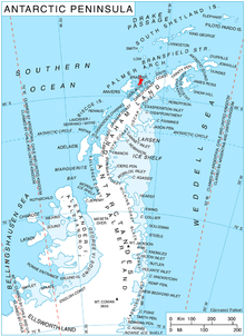
The Solvay Mountains are a mountain range that rises to 1590 m (Cook Summit) and extends in an ENE–WSW direction in the south part of Brabant Island, in the Palmer Archipelago of Antarctica. They were discovered by the Belgian Antarctic Expedition of 1897–99, under Adrien de Gerlache, and named by him for Ernest-John Solvay (1895-1972), the recently-born grandson of Ernest Solvay, who sponsored the expedition.[1] The name originally extended along the entire east coast of the island but has been limited to the prominent mountains in the south, while the principal group of mountains farther north was subsequently named Stribog Mountains, separated from Solvay Mountains by Aluzore Gap.
Mountains
Mount Aciar (64°24′S 62°33′W), variously known also as Monte Ferrer, Mount Ehrlich, Monte E, and Monte Primer Teniente Aciar,[2] rises to 1,300 metres (4,265 ft) between the heads of Rush Glacier and Jenner Glacier in the Solvay Mountains.[3]
Maps
- Antarctic Digital Database (ADD). Scale 1:250000 topographic map of Antarctica. Scientific Committee on Antarctic Research (SCAR). Since 1993, regularly upgraded and updated.
- British Antarctic Territory. Scale 1:200000 topographic map. DOS 610 Series, Sheet W 64 62. Directorate of Overseas Surveys, Tolworth, UK, 1980.
- Brabant Island to Argentine Islands. Scale 1:250000 topographic map. British Antarctic Survey, 2008.
References
- "A Trip around a name - The legacy of Ernest Solvay". Solvay. 30 July 2013. Archived from the original on 16 September 2018. Retrieved 14 December 2020.
- "Mount Aciar". Peakery. Retrieved 15 May 2013.
- "Mount Aciar, Antarctica". Peakbagger. Retrieved 15 May 2013.

![]() This article incorporates public domain material from the United States Geological Survey document: "Solvay Mountains". (content from the Geographic Names Information System)
This article incorporates public domain material from the United States Geological Survey document: "Solvay Mountains". (content from the Geographic Names Information System)
This Brabant Island location article is a stub. You can help Wikipedia by expanding it. |
На других языках
[de] Solvay Mountains
Die Solvay Mountains (französisch Monts Solvay) sind ein über 1500 m hohes Gebirge, das sich in ostnordöstlich-westsüdwestlicher Ausdehnung im Süden der Brabant-Insel im Palmer-Archipel erstreckt.- [en] Solvay Mountains
[it] Montagne di Solvay
Le montagne di Solvay sono una catena montuosa situata sull'isola Brabant, una delle isole dell'arcipelago Palmer, al largo della costa nord-occidentale della Terra di Graham, in Antartide. La catena è orientata in direzione est-nordest/ovest-sudovest, raggiungendo una lunghezza di 25 km e una larghezza di 10 ed estendendosi da punta Humann, a ovest, a punta d'Ursel, a est. Dai versanti delle montagne di Solvay, il cui punto più alto è costituito dalla vetta del monte Cook, che arriva a 1590 m s.l.m., e che sono separate alle montagne di Stribog, a nord, dal passo Aluzore, discendono diversi ghiacciai, come il Rush, il Jenner e il Koch.[1]Другой контент может иметь иную лицензию. Перед использованием материалов сайта WikiSort.org внимательно изучите правила лицензирования конкретных элементов наполнения сайта.
WikiSort.org - проект по пересортировке и дополнению контента Википедии