geo.wikisort.org - Mountains
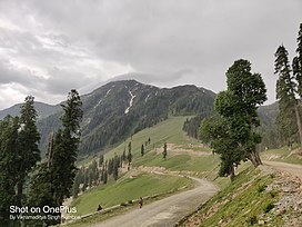
Sonbain or Sonbain Ashapati or Sonabain Glacier is a mountain massif in the Pir Panjal Range Himalayas of Jammu and Kashmir, India, east of the town of Bhaderwah and near the border with Himachal Pradesh.[3] The Sonabain glacier originates Neeru river.
| Sonbain | |
|---|---|
 Mt. Sonbain Ashapati, near Bhaderwah, District Doda, J&K, India. | |
| Highest point | |
| Elevation | 3,983 m (13,068 ft)[1] |
| Coordinates | 32°51′45″N 75°41′54″E[2] |
| Geography | |
| Location | Doda district, Jammu and Kashmir, India |
| Parent range | Pir Panjal Range Himalayas |
Etymology
The Sonbain word is derived from two Kashmiri words, Son means Golden and Bain means Spring.[4]
Geography
On the Bhaderwah-Bani-Basholi road, Gurdanda is a large ridge. The Sonbain glacier, which gives birth to the Neeru river, is located to its left.[5]
References
- "JAMMU: UNKNOWN GEMS". Outlook (magazine). 4 July 2017. Retrieved 20 September 2022.
- "Sonbain coordinates". Google Maps. Retrieved 20 September 2022.
- "Ashapati Glacier (Sonbain) – The origin of river Neeru | Bhaderwah". Retrieved 20 September 2022.
- Malik, Sadaket (20 October 2012). "Bhalessa heritage an eye opner".
- Sadaq, Mohd (18 October 2021). "Hidden beauty of Bhaderwah Valley". The Northern Herald. Retrieved 20 September 2022.
Текст в блоке "Читать" взят с сайта "Википедия" и доступен по лицензии Creative Commons Attribution-ShareAlike; в отдельных случаях могут действовать дополнительные условия.
Другой контент может иметь иную лицензию. Перед использованием материалов сайта WikiSort.org внимательно изучите правила лицензирования конкретных элементов наполнения сайта.
Другой контент может иметь иную лицензию. Перед использованием материалов сайта WikiSort.org внимательно изучите правила лицензирования конкретных элементов наполнения сайта.
2019-2025
WikiSort.org - проект по пересортировке и дополнению контента Википедии
WikiSort.org - проект по пересортировке и дополнению контента Википедии

