geo.wikisort.org - Mountains
The Sierra de Los Tuxtlas (Tuxtlas Mountains) are a volcanic belt and mountain range along the southeastern Veracruz Gulf coast in Eastern Mexico. The Los Tuxtlas Biosphere Reserve (Biósfera Los Tuxtlas) includes the coastal and higher elevations of the Sierra de Los Tuxtlas.
| Sierra de los Tuxtlas | |
|---|---|
 Cloud-shrouded San Martin Tuxtla | |
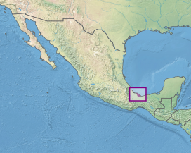 Location of the Sierra de los Tuxtlas | |
| Ecology | |
| Realm | Neotropical |
| Biome | tropical and subtropical moist broadleaf forests |
| Borders | Petén–Veracruz moist forests |
| Geography | |
| Area | 3,813 km2 (1,472 sq mi) |
| Country | Mexico |
| States | Veracruz |
| Conservation | |
| Conservation status | Critical/endangered |
| Protected | 1,519 km² (40%)[1] |
The volcanic mountains were used as a basalt source by the Olmec culture during the Early Formative period (1500 BCE to about 400 BCE). Quarried basalt was transported by raft through a network of rivers, to sites in the Olmec heartland for use in creating monuments, including colossal heads.[2]
Geography
Peaks in this range include Volcano Santa Marta and Volcano San Martín Tuxtla, both rising above 1,700 meters. San Martín Tuxtla is the only recently active volcano in the belt, erupting in 1664 and again in May 1793. It is a broad alkaline shield volcano with a one kilometer wide summit. Hundreds of smaller cinder cones are prevalent throughout the Sierra.
Other, extinct volcanoes include San Martin Pajapan (1,160 meters) and Cerro El Vigia (800 meters).
The Sierra de Los Tuxtlas volcanoes are an insular anomaly. The volcanoes are separated from the nearest volcano in the Trans-Mexican Volcanic Belt to the west by about 150 miles (250 km), and from the Central American Volcanic Belt to the southeast by almost 200 miles (330 km).
Natural history
The upper flanks of the San Martin Tuxtla and Santa Marta volcanoes are covered with the Neotropical Sierra de los Tuxtlas tropical rainforest ecoregion, of the tropical and subtropical moist broadleaf forests biome. The lower portions are covered with stunted pastures and grasslands.
The Tuxtla quail-dove (Zentrygon carrikeri) is endemic to the ecoregion.
Volcan San Martin rainfrog, Craugastor vulcani, is an endangered frog endemic to rain and cloud forests of Sierra de los Tuxtlas.[3][4] The area is also home to an endemic species of giant scarab beetle, Dynastes moroni, described in 2005.[5]
See also
- List of ecoregions in Mexico
References
- Dinerstein, Eric; Olson, David; et al. (June 2017). "An Ecoregion-Based Approach to Protecting Half the Terrestrial Realm". BioScience. 67 (6): 534–545. doi:10.1093/biosci/bix014. PMC 5451287. PMID 28608869.
{{cite journal}}: CS1 maint: date and year (link) Supplemental material 2 table S1b. - Ancient Mexico and Central America
- Frost, Darrel R. (2014). "Craugastor vulcani (Shannon and Werler, 1955)". Amphibian Species of the World: an Online Reference. Version 6.0. American Museum of Natural History. Retrieved 25 December 2014.
- Santos-Barrera, G. (2004). "Craugastor vulcani". IUCN Red List of Threatened Species. 2004: e.T57050A11574639. doi:10.2305/IUCN.UK.2004.RLTS.T57050A11574639.en. Retrieved 10 January 2018.
- Ratcliffe, B. C., R. D. Cave, and E. Cano. 2013. The dynastine scarab beetles of Mexico, Guatemala, and Belize (Coleoptera: Scarabaeidae). Bulletin of the University of Nebraska State Museum 27: 1-666.
- Yarza de la Torre, Esperanza (1971). Volcanes de México. Aguilar. p. 237 pp. (in Spanish)
- "San Martín Pajapan". Global Volcanism Program. Smithsonian Institution.
External links
На других языках
[de] Sierra de los Tuxtlas
Die Sierra de Los Tuxtlas (Tuxtla-Gebirge) ist ein isoliert liegender und vergleichsweise kleiner Gebirgszug vulkanischen Ursprungs an der mexikanischen Golfküste.- [en] Sierra de los Tuxtlas
[es] Sierra de los Tuxtlas
La Sierra de Los Tuxtlas —conocida también como Sierra de Santa Martha y Sierra de Tuxtla— es una cordillera volcánica que bordea la costa veracruzana del golfo de México, aproximadamente en la latitud de los 19º N. Algunas eminencias de esta cadena de volcanes son los cerros Santa Martha y San Martín, que alcanzan altitudes de 1700 msnm. El único con actividad volcánica conocida es el San Martín, que hizo erupción en 1664 y 1793. Otros volcanes extintos son el volcán San Martìn Pajapan (1160 msnm) y el cerro de El Vigía (800 msnm).[fr] Sierra de los Tuxtlas
La sierra de Los Tuxtlas (monts Tuxtlas) est une ceinture volcanique qui borde la côte septentrionale de l'État de Veracruz au centre de la partie méridionale du golfe du Mexique. Les sommets de la région comprennent le volcan Santa Marta et le volcan San Martín Tuxtla, dépassant tous les deux 1 700 mètres d'altitude. San Martín Tuxtla est le seul volcan ayant été récemment actif dans la sierra. Il a été en éruption en 1664 et de nouveau en mai 1793. C'est un volcan bouclier alcalin avec un sommet d'un kilomètre de diamètre. On y trouve aussi d'autres volcans éteints moins hauts comme San Martin Pajapan (1 160 mètres) et le Cerro El Vigia (800 mètres). Des centaines de petits cônes volcaniques sont répandus dans toute la sierra.[it] Sierra de los Tuxtlas
La Sierra de los Tuxtlas («Monti Tuxtla») è una catena montuosa vulcanica isolata e relativamente piccola situata presso la costa messicana che si affaccia sul golfo del Messico. La parola nahuatl Tuxtla deriva dall'azteco Tochtlan, che significa «luogo dei conigli». Proprio un coniglio campeggia al centro dello stemma di San Andrés Tuxtla.Другой контент может иметь иную лицензию. Перед использованием материалов сайта WikiSort.org внимательно изучите правила лицензирования конкретных элементов наполнения сайта.
WikiSort.org - проект по пересортировке и дополнению контента Википедии