geo.wikisort.org - Mountains
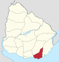
Sierra Carapé or Sierra de Carapé is a hill range located in Maldonado Department, in southern Uruguay. The range crosses the Maldonado Department from west to east and enters the Rocha Department.
| Sierra Carapé | |
|---|---|
 A rocky summit in this range of hills. | |
| Highest point | |
| Peak | Cerro Catedral (Cathedral Hill) |
| Elevation | 513.66 m (1,685.2 ft) |
| Coordinates | 34°22′55.9″S 54°40′27.7″W |
| Geography | |
 | |
| Country | Uruguay |
| Range coordinates | 34°20′S 54°39′W |
| Parent range | Cuchilla Grande |
| Geology | |
| Age of rock | Precambrian |
| Type of rock | Granite, gneiss |
Local demarcation
It constitutes the border between the departments of Lavalleja and Maldonado, in south-eastern Uruguay. This hill range constitutes part of a larger range named Cuchilla Grande.
Highest point in Uruguay
This range has the highest point of the country, the Cerro Catedral, with 513.66 metres (1,685.24 feet) of altitude.
See also
- Geography of Uruguay
- Cerro Catedral (Uruguay)#Location and geology
External links
- (in Spanish) Cerro Catedral, Site of the Municipality of Maldonado, Uruguay.
- (in English) Peakbagger.com: Cerro Catedral, Uruguay
Capital: | ||
| Municipalities |
|  |
| Towns and villages |
| |
| Sights |
| |
This article about a place in Maldonado Department is a stub. You can help Wikipedia by expanding it. |
На других языках
[de] Sierra Carapé
Die Sierra Carapé (auch bekannt als Sierra de Carapé) ist eine kleinere Hügelkette im Süden von Uruguay. Sie verläuft vom Departamento Maldonado ostwärts in das Departamento Rocha im Osten. Die Hügelkette stellt die Grenze zum nördlich gelegenen Departamento Lavalleja dar. Die Sierra Carapé schließt im Norden unmittelbar an die Cuchilla Grande an.- [en] Sierra Carapé
Текст в блоке "Читать" взят с сайта "Википедия" и доступен по лицензии Creative Commons Attribution-ShareAlike; в отдельных случаях могут действовать дополнительные условия.
Другой контент может иметь иную лицензию. Перед использованием материалов сайта WikiSort.org внимательно изучите правила лицензирования конкретных элементов наполнения сайта.
Другой контент может иметь иную лицензию. Перед использованием материалов сайта WikiSort.org внимательно изучите правила лицензирования конкретных элементов наполнения сайта.
2019-2026
WikiSort.org - проект по пересортировке и дополнению контента Википедии
WikiSort.org - проект по пересортировке и дополнению контента Википедии