geo.wikisort.org - Mountains
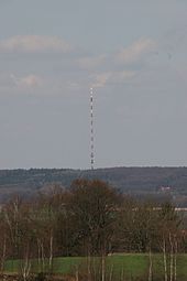
The Schleptruper Egge is a hill, 148 m high, in the Bramsche parish of Schleptrup and is part of the Wiehen Hills. To the north is the bog of Großes Moor at a height of about 47 m above sea level (NHN), the Mittelland Canal built in the 20th century and the Bramsche parish of Kalkriese. Immediately east of the Schleptruper Egge runs the A 1 motorway, the so-calle Hanseatic Line (Hansalinie).
This article does not cite any sources. (June 2019) |
| Schleptruper Egge | |
|---|---|
| Highest point | |
| Elevation | 148 m above sea level (NHN) (486 ft) |
| Listing | Schleptruper Egge Transmitter |
| Coordinates | 52°22′27″N 8°01′52″E |
| Geography | |
| Location | Bramsche |
| Parent range | Wiehen Hills |

On the top of the Schleptruper Egge is the mast of the NDR Osnabrück-Engter Transmitter. The long distance path of Hünenweg, managed by the Weser-Ems Wiehen Hills Society (Wiehengebirgsverband Weser-Ems), which runs from Osnabrück to Papenburg, also leads over the Schleptruper Egge.
На других языках
[de] Schleptruper Egge
Die Schleptruper Egge ist eine 146,9 m ü. NHN hohe Erhebung im Bramscher Ortsteil Schleptrup als Teil des Wiehengebirges.[1]- [en] Schleptruper Egge
Текст в блоке "Читать" взят с сайта "Википедия" и доступен по лицензии Creative Commons Attribution-ShareAlike; в отдельных случаях могут действовать дополнительные условия.
Другой контент может иметь иную лицензию. Перед использованием материалов сайта WikiSort.org внимательно изучите правила лицензирования конкретных элементов наполнения сайта.
Другой контент может иметь иную лицензию. Перед использованием материалов сайта WikiSort.org внимательно изучите правила лицензирования конкретных элементов наполнения сайта.
2019-2025
WikiSort.org - проект по пересортировке и дополнению контента Википедии
WikiSort.org - проект по пересортировке и дополнению контента Википедии
