geo.wikisort.org - Mountains
Muztagh Ata or Muztagata (Uighur: مۇز تاغ ئاتا, Музтағ Ата, literally "ice-mountain-father"; Chinese: 慕士塔格峰; pinyin: Mùshìtǎgé Fēng; formerly known as Mount Tagharma or Taghalma and Wi-tagh) is the second highest (7509 metres)[2] of the mountains which form the northern edge of the Tibetan Plateau in China (not the second highest of the mountains of the Tibetan Plateau). It is sometimes regarded as being part of the Kunlun Mountains, although physically it is more closely connected to the Pamirs. It is also one of the relatively easier 7,000 m peaks in the world to climb, due to its gentle western slope and the comparatively drier weather of Xinjiang, though a thorough acclimatization period and a very strong physical condition are crucial for success.
| Muztagh Ata | |
|---|---|
| Mushitage | |
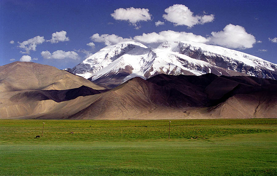 Muztagh Ata, as viewed from the Karakoram Highway | |
| Highest point | |
| Elevation | 7,509 m (24,636 ft)[1][2] Ranked 49th |
| Prominence | 2,698 m (8,852 ft)[1] |
| Listing | Ultra |
| Coordinates | 38°16′42″N 75°06′57″E[1] |
| Naming | |
| English translation | Father of ice mountains |
| Language of name | Uyghur |
| Geography | |
 Muztagh Ata China | |
| Location | Xinjiang, China |
| Parent range | Pamir Range |
| Climbing | |
| First ascent | 1956 by E. A. Beletskiy et al. |
| Easiest route | Glacier/snow climb |
Location
Muztagh Ata lies just south of Kongur Tagh, the highest peak of this somewhat isolated range that is separated from the main chain of the Kunlun by the large Yarkand River valley, and thus generally included in the "Eastern Pamirs".[3] Not far to the north and east of this group are the lowlands of the Tarim Basin and the Taklamakan Desert. The Karakoram Highway passes very close to both peaks as well as Karakul Lake, from which the mountain is conveniently viewed. The closest city is to the mountain is Tashkurgan, the westernmost town in China and very close to the border with Tajikistan and Pakistan.
History
According to Michael Witzel:[4]
the Ṛgveda mentions the mountain Mūjavant (“Having Mūja”), from where the best soma comes. A Muža tribe is also found in the Avesta in an eastern area that has Vedic-like names. The name seems to survive as the impressive 7,549-meter-high Muzh Tagh Ata Mountain in the Kirghiz and Sariqoli (Saka) lands of southwestern Xinjiang.
The Swedish explorer and geographer Sven Hedin made the first recorded attempt to climb Muztagh Ata, in 1894. On his first expedition in 1900 Aurel Stein reached the summit while crossing the Karakorum Pass.[5] Additional attempts were made in 1900, 1904 and 1947, the last by the team of Eric Shipton and Bill Tilman who came very close to the summit but were turned back due to cold and deep snow.
The first ascent of the peak was in 1956 by a large party of Chinese and Soviet climbers (including Liu Lianman and Xu Jing) led by E.A. Beletskiy, via the west ridge, which is now the standard route.
Since the first ascent, many ascents of Muztagh Ata have been made. In 1980, a party led by Ned Gillette made a ski ascent/descent of the standard route, the first ski ascent of a mountain over 7,500 m (24,600 ft). An ascent of the much harder south-east ridge was made in 2000 [6] and a secondary route at the west side of the mountain was first climbed in the summer of 2005. In 2011 the Swedish climber Anneli Wester camped on the summit overnight after climbing the mountain solo and alpine style.
Notes
- "China II: Sinkiang – Xinjiang". Peaklist.org. Retrieved 26 May 2014.
- Note: The footnote in this source states: "The frequently cited 7546m elevation should be replaced by the newer 7509m elevation that appears on Chinese maps, and is more compatible with SRTM." "China II: Sinkiang – Xinjiang". Footnote#9. Peaklist.org. Retrieved 26 May 2014.
- N. O. Arnaud; M. Brunel; J. M. Cantagrel; P. Tapponnier (1993). "High cooling and denudation rates at Kongur Shan, Eastern Pamir (Xinjiang, China)". Tectonics. 12 (3): 1335–1346. doi:10.1029/93TC00767.
- Witzel, Michael (2012). "Vedic Gods (Indra, Agni, Rudra, Varuṇa, etc.)". Brill's Encyclopedia of Hinduism. Brill.
- Meyer, Karl E. (2009). Tournament of Shadows : the Great Game and the Race for Empire in Central Asia. Basic Books. p. 355. ISBN 978-0-7867-3678-2. OCLC 817868028.
- "Asia, Muztag Ata, 2nd Ascent of Southeast Ridge". American Alpine Club. Retrieved 28 July 2021.
Sources
- Jill Neate, High Asia: An Illustrated History of the 7000 Metre Peaks, ISBN 0-89886-238-8.
- Himalayan Index
External links
- Muztagh Ata on summitpost.org (much information)
- Muztagh ata Information
- muztagh ata informations
- Muztagh Ata in Kyrgyzstan
Authority control | |
|---|---|
| General |
|
| National libraries | |
На других языках
[de] Muztagata
Der Muztagata ist mit einer Höhe von 7509 m der dritthöchste Gipfel des Pamir-Gebirges in der Volksrepublik China.- [en] Muztagh Ata
[es] Muztagh Ata
El Muztagh Ata, que significa "padre de los hielos", es el segundo pico más alto de la cordillera de Kunlun, por detrás del Kongur.[fr] Mustagh Ata
Mustagh Ata, ou Muztagata, en ouïghour : مۇز تاغ ئاتا, littéralement « Père des montagnes de glace », est un sommet situé dans la région autonome ouïghoure du Xinjiang en République populaire de Chine, non loin du Pakistan. Il culmine à 7 546 m d'altitude. Il est parfois considéré comme faisant partie de la cordillère du Kunlun, bien que géographiquement plus proche de celle du Pamir[réf. nécessaire]. Compte tenu de sa face Ouest dont la pente est relativement douce et au climat sec de la région, il est considéré comme étant l'un des sommets de plus de 7 000 mètres les plus faciles.[it] Muztagata
Il Muztagata[1][2] (o Muztagh Ata; in uiguro مۇز تاغ ئاتا, Музтағ Ата; in cinese: 慕士塔格峰; in pinyin: Mùshìtǎgé Fēng) è la seconda vetta più alta del Pamir (o del Kunlun, come indicano altre fonti). Il nome deriva dall'uiguro e significa padre delle montagne ghiacciate.[ru] Музтагата
Музтагата́[2] (кит. упр. 慕士塔格峰, пиньинь Mùshìtǎgé Fēng, уйг. مۇز تاغ ئاتا, Музтағ Ата — «отец ледяных гор») — гора на Памире, расположенная на территории СУАР, Китай. Высота 7546 м, из-за пологого западного склона и относительно сухой погоды в регионе является одним из наиболее легко покоряемых пиков выше 7 тыс. м.Другой контент может иметь иную лицензию. Перед использованием материалов сайта WikiSort.org внимательно изучите правила лицензирования конкретных элементов наполнения сайта.
WikiSort.org - проект по пересортировке и дополнению контента Википедии