geo.wikisort.org - Mountains
Kongur Tagh or Kongkoerh (Kyrgyz: Коңур Тоо; Uyghur: قوڭۇر تاغ, Коңур Тағ, meaning "Brown Mountain"; Mongolian: Хонгор Таг, (Хонгор/Kongur/Kongur is Mongolian word for the color Mongolians use for Buckskin colored horse) Hongor Tag; simplified Chinese: 公格尔峰; traditional Chinese: 公格爾峰; pinyin: Gōnggé'ěr Fēng; also referred to as Kongur), is the highest peak in the Pamir Mountains, and also the highest mountain wholly within the Xinjiang Uyghur Autonomous Region, China. With an elevation of 7,649 metres (25,095 ft), it is also the highest mountain outside of the Hindu Kush/Karakoram and Himalaya ranges.
| Kongur Tagh | |
|---|---|
| Kongkhoerh | |
 South face of Kongur Tagh | |
| Highest point | |
| Elevation | 7,649 m (25,095 ft)[1] Ranked 37th |
| Prominence | 3,585 m (11,762 ft)[1] Ranked 49th |
| Isolation | 240 km (150 mi) |
| Listing | Ultra |
| Coordinates | 38°35′39″N 75°18′48″E[1] |
| Geography | |
 Kongur Tagh Location in Xinjiang | |
| Location | Akto County, Xinjiang, China |
| Parent range | Pamir Mountains |
| Climbing | |
| First ascent | 1981 by British team |
| Easiest route | Rock/snow/ice climb |
Geography
Kongur Tagh is within a range called the Kongur Shan (Chinese: 公格尔山; pinyin: Gōnggé'ěr Shān.) Kongur Tagh is located just north of Muztagh Ata and visible from Karakul Lake. Some sources use "Kongur Shan" mistakenly to refer to the peak itself. The Kongur Shan range, including Muztagh Ata, is separated by the major Yarkand River valley from the Kunlun Mountains and thus is included in the "Eastern Pamirs".[2] Kongur Tagh is the highest peak in the Pamirs. Due to its remoteness and being hidden by nearby peaks, Kongur was not discovered by Europeans until 1900. However, the building of the Karakoram Highway from Pakistan to China, which runs past nearby Tashkurgan and Karakul Lake, has now made it more accessible.
Administratively, the Kongur Range is within Akto County.
Climbing history
The first attempt to climb Kongur Tagh was made in 1956 but the party aborted the attempt when it realized it was beyond their abilities[citation needed].
The first ascent of Kongur Tagh was completed in 1981 by a British expedition consisting of Chris Bonington, Al Rouse, Peter Boardman and Joe Tasker.[3]
Elevation
Kongur Tagh is 7,649 meters high. Some sources list the peak's elevation as 7,719 meters, but this is likely incorrect. The main summit is close enough in height to the 7,625-meter-high northeastern summit that climbers standing on the main summit could not tell which was taller, thus it can not be 7,719 meters high.[4]
 Kongur Tagh Karakoram Highway Kashgar Xinjiang China
 Kongur Tagh (towards the right edge of the photo) and Kongur Tiube (center) as seen from lake Karakul
 The Kongur Tagh range in 2005. The summits visible from the viewpoint on the Karakoram highway to the southwest are those of Kuk Sel (6,715 metres) and Kezi Sel (6,525 metres), about 5 km and 7 km south of the main summit.
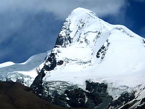 Kongur Tagh, 2011


Footnotes
- "China II: Sinkiang - Xinjiang". Peaklist.org. Retrieved 2014-05-26.
- N. O. Arnaud; M. Brunel; J. M. Cantagrel; P. Tapponnier (1993). "High cooling and denudation rates at Kongur Shan, Eastern Pamir (Xinjiang, China)". Tectonics. 12 (3): 1335–1346. doi:10.1029/93TC00767.
- Ward (1983), pp. 146-148.
- "Summit Elevations: Frequent Internet Errors". www.viewfinderpanoramas.org. Retrieved 2021-09-20.
See also
- Karakoram Highway
- Kongur Tiube
References
- Ward, Michael. (1983). "The Kongur Massif in Southern Sinkiang." The Geographical Journal, Vol. 149, No. 2 (Jul., 1983), pp. 137–152.
External links
- "Kongkoerh, China". Peakbagger.com. Retrieved May 23, 2008.
Authority control | |
|---|---|
| General |
|
| National libraries | |
На других языках
[de] Kongur
Der Kongur bzw. Kongur Tagh (auch Kungur, Qungur tagh[1] genannt; uigurisch .mw-parser-output .Arab a,.mw-parser-output a bdi.Arab{text-decoration:none!important}.mw-parser-output .Arab{font-size:120%}قوڭۇر تاغ .mw-parser-output .Latn{font-family:"Akzidenz Grotesk","Arial","Avant Garde Gothic","Calibri","Futura","Geneva","Gill Sans","Helvetica","Lucida Grande","Lucida Sans Unicode","Lucida Grande","Stone Sans","Tahoma","Trebuchet","Univers","Verdana"}Qongur Tagh; chinesisch .mw-parser-output .Hani{font-size:110%}公格尔峰, Pinyin Gōnggé'ěr Fēng) ist mit 7649 m über dem Meeresspiegel, nach anderen Angaben 7719 m, der höchste Berg des Pamir-Gebirges. Die Berggruppe um den Kongur Tagh trägt den Namen Kongur Shan (chinesisch 公格尔山, Pinyin Gōnggé'ěr Shān), diese Bezeichnung wird fälschlicherweise auch für den Hauptgipfel alleine verwendet.- [en] Kongur Tagh
[es] Kongur
El Kongur, también llamado Kongur Tagh y Kongur Shan (Uyghur: قوڭۇر تاغ, Коңур Тағ; en mongol, Хонгор Таг, Hongor Tag; en chino, 公格尔峰; pinyin, Gōnggé'ěr Fēng), es el pico más alto de las montañas Kunlun en la República Popular China Al encontrarse en un lugar remoto y rodeado por otros picos de considerable altura, el Kongur no se descubrió hasta el año 1900.[fr] Kongur
Le Kongur ou Kongur Tagh (mongol : Хонгор Таг ; chinois simplifié: 公格尔峰 ; chinois traditionnel : 公格爾峰 ; pinyin : gōng gé'ěr fēng) est le plus haut sommet de la cordillère du Kunlun en Chine et culmine à 7 649 m.[it] Kungur Tagh
Il Kungur (o Kongur Tagh; in cinese: 公格尔山; in pinyin: Gōnggé'ěr Shān) è la vetta principale del Pamir. Il punto più alto arriva a 7649 m s.l.m.: è la 37ª vetta più alta del mondo.[ru] Конгур
Конгу́р (уйг. قوڭۇر تاغ, Қоңур Тағ — «коричневая гора», кит. упр. 公格尔山, пиньинь Gōnggé'ěr Shān, монг. Хонгор Таг) — горный массив в хребте Конгурмузтаг в китайской части Памира, расположен на территории Синьцзян-Уйгурского автономного района. Вершины Конгур (7649 м), Конгуртюбе (7530 м) и Музтаг-Ата (7546) — самые высокие пики хребта Конгурмузтаг.Другой контент может иметь иную лицензию. Перед использованием материалов сайта WikiSort.org внимательно изучите правила лицензирования конкретных элементов наполнения сайта.
WikiSort.org - проект по пересортировке и дополнению контента Википедии