geo.wikisort.org - Mountains
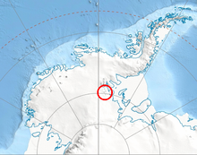
Muir Peak (79°9′S 86°25′W) is a conspicuous rock peak near the middle of Frazier Ridge in the Founders Peaks, Heritage Range. It was mapped by the United States Geological Survey (USGS) from surveys and U.S. Navy air photos from 1961 to 1966. It was named by the Advisory Committee on Antarctic Names (US-ACAN) for Hugh M. Muir, a United States Antarctic Research Program (USARP) auroral scientist and member of the winter party at the Plateau Station in 1966.
See also
- Mountains in Antarctica
References
![]() This article incorporates public domain material from the United States Geological Survey document: "Muir Peak". (content from the Geographic Names Information System)
This article incorporates public domain material from the United States Geological Survey document: "Muir Peak". (content from the Geographic Names Information System)
Antarctica | ||||||||
|---|---|---|---|---|---|---|---|---|
| Geography |
|  | ||||||
| History |
| |||||||
| Politics |
| |||||||
| Society |
| |||||||
| Famous explorers |
| |||||||
| ||||||||
This Ellsworth Land location article is a stub. You can help Wikipedia by expanding it. |
Текст в блоке "Читать" взят с сайта "Википедия" и доступен по лицензии Creative Commons Attribution-ShareAlike; в отдельных случаях могут действовать дополнительные условия.
Другой контент может иметь иную лицензию. Перед использованием материалов сайта WikiSort.org внимательно изучите правила лицензирования конкретных элементов наполнения сайта.
Другой контент может иметь иную лицензию. Перед использованием материалов сайта WikiSort.org внимательно изучите правила лицензирования конкретных элементов наполнения сайта.
2019-2026
WikiSort.org - проект по пересортировке и дополнению контента Википедии
WikiSort.org - проект по пересортировке и дополнению контента Википедии