geo.wikisort.org - Mountains
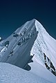
Mount Tasman (Horokoau in Māori) is New Zealand's second highest mountain, rising to a height of 3,497 metres (11,473 ft). It is located in the Southern Alps of the South Island, four kilometres to the north of its larger neighbour, Aoraki / Mount Cook. Unlike Aoraki / Mount Cook, Mount Tasman sits on the South Island's Main Divide, on the border between Aoraki / Mount Cook National Park and Westland Tai Poutini National Park. It is the highest point in Westland District.
This article needs additional citations for verification. (November 2019) |
| Mount Tasman | |
|---|---|
 | |
| Highest point | |
| Elevation | 3,497 m (11,473 ft) |
| Prominence | 519 m (1,703 ft) |
| Isolation | 3.22 km (2.00 mi) |
| Listing | New Zealand #2 |
| Coordinates | 43°34′S 170°9′E |
| Naming | |
| Native name | Horokoau (Māori) |
| Geography | |
 Mount Tasman South Island, New Zealand | |
| Parent range | Southern Alps |
| Climbing | |
| First ascent | February 1895 by Edward Fitzgerald, Matthias Zurbriggen und Jack Clarke |
| Easiest route | glacier/snow/ice climb |
The first ascent of Mount Tasman was in 1895 by Edward FitzGerald and his guide Matthias Zurbriggen.[1]
The Māori name (horo: to swallow; koau: shag or Phalacrocorax varius) is believed to refer to the swelling in the neck of a shag when it is swallowing a fish.[2]
Aoraki / Mount Cook National Park
Mount Tasman is located in Aoraki / Mount Cook National Park in the Canterbury region, which was established in 1953 and along with Westland Tai Poutini National Park, Mount Aspiring National Park and Fiordland National Park forms one of the UNESCO World Heritage Sites.
Gallery
 Mt Tasman north shoulder view south to summit, 21 March 1983
 Mt Tasman peak looking SW from Mt Haidinger summit, 19 March 1983
 Mt Haast, Mt Lendenfeld, Mt Tasman and Torres Peak NZ helicopter view from NW, Nov 28 2008
 Mt Tasman helicopter view from SE above Grand Plateau, Nov 28 2008
 Mt Tasman viewed from north at helicopter landing on Fox nevé, Nov 28 2008


See also
References
- Wilson, John. "Mountaineering – Aoraki/Mt Cook". Te Ara: The Encyclopedia of New Zealand. Retrieved 5 December 2020.
- Reed, A. W. (2010). Peter Dowling (ed.). Place Names of New Zealand. Rosedale, North Shore: Raupo. p. 391. ISBN 9780143204107.
Authority control | |
|---|---|
| General |
|
| National libraries | |
This West Coast Region (New Zealand) geography article is a stub. You can help Wikipedia by expanding it. |
This Canterbury Region-related geography article is a stub. You can help Wikipedia by expanding it. |
На других языках
[de] Mount Tasman
Mount Tasman (auch Rarakiroa[1]) ist mit 3498 m der zweithöchste Berg Neuseelands. Er liegt in den Neuseeländischen Alpen auf der Südinsel im Aoraki/Mount Cook National Park. In seiner unmittelbaren Nähe (vier Kilometer südlich) befindet sich der höchste Berg Neuseelands, der 3724 m hohe Aoraki/Mount Cook.- [en] Mount Tasman
[fr] Mont Tasman
Le mont Tasman, appelé Rarakiora en maori, est le deuxième plus haut sommet de Nouvelle-Zélande. Il fait partie des Alpes du Sud et se trouve à la limite entre les régions de West Coast et de Canterbury. Il culmine à 3 497 mètres d'altitude.[it] Monte Tasman
Il monte Tasman (Horokoau in lingua māori) è la seconda cima più alta della Nuova Zelanda, ergendosi infatti a 3497 metri sul livello del mare. Appartenente alla catena delle Alpi meridionali, sorge sull'Isola del Sud a soli 4 chilometri dalla vetta più alta del Paese, il monte Cook (Aoraki lingua māori). Diversamente da quest'ultimo, tuttavia, il monte Tasman è situato sulla linea spartiacque che divide l'isola in un versante occidentale ed uno orientale. Il monte stesso fa parte di due parchi nazionali: il versante orientale ricade infatti nel Parco nazionale dell'Aoraki/Monte Cook, mentre quello occidentale nel Parco nazionale Westland Tai Poutini.[ru] Гора Тасмана
Гора́ Тасмана (англ. Mount Tasman), или Хоро-Коау (маори Horo-Koau), — гора в новозеландских Южных Альпах, вторая по высоте (3497 м) точка Новой Зеландии, находится в 4 км от высочайшего пика страны — горы Кука.Другой контент может иметь иную лицензию. Перед использованием материалов сайта WikiSort.org внимательно изучите правила лицензирования конкретных элементов наполнения сайта.
WikiSort.org - проект по пересортировке и дополнению контента Википедии