geo.wikisort.org - Mountains
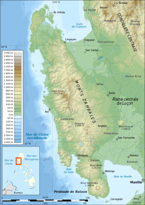
Mount Tapulao (also known as High Peak) is the highest mountain in the Zambales Mountain Range and in the province of Zambales in the Philippines. The peak, which rise to an elevation of 2,037 metres (6,683 ft) above sea level, and it is located in the municipality of Palauig, Zambales. Its name is derived from the abundance of Sumatran Pine trees in the area, known in Zambal as tapolaw.[1][3]
| Mount Tapulao | |
|---|---|
| High Peak | |
 Pine forest of Mount Tapulao | |
| Highest point | |
| Elevation | 2,037 m (6,683 ft)[1] |
| Prominence | 2,009 m (6,591 ft)[2] |
| Listing | Ultra |
| Coordinates | 15°28′51″N 120°7′16″E |
| Geography | |
 Mount Tapulao Location within the Philippines | |
| Location | Luzon |
| Country | Philippines |
| Region | Central Luzon |
| Province | Zambales |
| Municipality | Palauig |
| Parent range | Zambales Mountains |
| Climbing | |
| Easiest route | Dampay Resettlement Area, Brgy. Salaza, Palauig |
The mountain was once a site of a large-scale chromite mining operations.[1] The destruction of the beautiful natural scenery is visible in the mine pits on the summit as well as other related structures along the trail. The summit offers a 360-degree vista from where you can see the other Zambales mountains on the eastern side, Lingayen Gulf to the north, and on the western side, the Zambales lowlands and the South China Sea stretching to as far south as Pundaquit in San Antonio, Zambales.
Hiking activity
The trail to the top of Mount Tapulao is on rolling and gradual terrain that takes hikers through a number of distinct ecosystems: from lowland grass and scrubland dominated by talahib (cogon grass) to its flanks of secondary to primary dipterocarp forest, mossy montane forest and pine forest above 1,800 metres (5,900 ft) that extends to the adjacent mountains.[3]
During wet weather, limatik or forest leeches abound especially near the streams along the way. Parts of the trail become rivulets that trekkers easily attracts these critters without noticing being bitten, sticking on the human skin.
From Palauig
Mount Tapulao can be reached by trekking the mining road on a ridge on the side of the mountain with the forest line starting at about 1,875 metres (6,152 ft).[1] The jump-off point is from the Dampay resettlement area in Brgy. Salaza in Palauig, which is around 8 kilometres (5.0 mi) from the Zambales Regional Highway on rough road. From the trailhead at Brgy. Dampay to the summit is around 18 kilometres (11 mi). Residents of Dampay are evacuees from the foot of Mount Pinatubo and are the "self-appointed guardians" of Mt. Tapulao under the coordination of the Municipal Tourism Authority of Palauig, Zambales.[4]
The ascent can be done in 7–8 hours while the descent can be covered in half the time. Guest and tourist aiming to climb the mountain are required to register at the barangay hall to receive further safety, security and cooperation according to the rule and guidance of the tourism authority. Farther down the settlement is a trail leading to the jump off-point for the Bagsit River whitewater river rafting.
Traverse hike
A traverse hike is also possible starting from the eastern side of the Mount Tapulao in Brgy. Labney in the town of Mayantoc in Tarlac province, ending in Palauig, or vice versa. The trail from the northwest is longer and a much more challenging route than the one from Zambales, but the reward is a more diverse environment and fauna.[5]
Ecosystem
- Department of Environment and Natural Resources (DENR) region 3 has signed a memorandum of agreement for the protection and development of 5,000-hectare (12,000-acre) Mt. Tapulao.
- Sangguniang Bayan (SB) of Iba, Zambales came out with an ordinance declaring the town's part of Mt. Tapulao as an eco-tourism destination and a protected area.
See also
- List of mountains in the Philippines
- List of Southeast Asian mountains
- Geography of the Philippines
References
- (2007-09-01). "Mt. Tapulao (2,037+)". Pinoy Mountaineer. Retrieved on 2012-02-11.
- "Philippines Mountains: Ultras" Listed as "High Peak" (Luzon). Peaklist.org. Retrieved 12-11-2012.
- "Zambales Mountains" Archived 2013-07-18 at the Wayback Machine. NewCAPP. Retrieved on 2012-02-15.
- "List of Ecotourism Sites in Central Luzon, Philippines". Philippine Department of Tourism Website. Retrieved on 2012-02-11.
- "Mt. Tapulao/ Tarlac-Zambales Traverse (2,037 +)". Pinoy Mountaineer. Retrieved on 2012-02-11.
External links
- New Rodent Species Discovered on Philippine Mountain
- 25 Highest Mountains in the Philippines
- Philippines Mountain Ultra-Prominence
Tourism in Central Luzon | ||
|---|---|---|
Aurora, Bataan, Bulacan, Nueva Ecija, Pampanga, Tarlac and Zambales attractions | ||
| Beaches and islands |
|  |
| Cultural |
| |
| Historical |
| |
| Parks and recreation |
| |
| Religious |
| |
| Venues |
| |
Tourism in the Philippines | ||
На других языках
[de] Tapulao
Der Tapulao ist mit einer Höhe von 2037 m der höchste Berg in der Provinz Zambales auf den Philippinen. Er ist auch unter dem Namen High Peak bekannt und auf vielen Landkarten so benannt.- [en] Mount Tapulao
Другой контент может иметь иную лицензию. Перед использованием материалов сайта WikiSort.org внимательно изучите правила лицензирования конкретных элементов наполнения сайта.
WikiSort.org - проект по пересортировке и дополнению контента Википедии