geo.wikisort.org - Mountains
Mount Tammany is the southernmost peak of the Kittatinny Mountains, in Knowlton Township, Warren County, New Jersey, United States. It is 1,526 feet (465 m) tall, and forms the east side of the Delaware Water Gap. Across the Gap is Mount Minsi, on the Pennsylvania side of the river. The mountain is named after the Lenni Lenape chief Tamanend.[2] It lies along the Appalachian Trail in Worthington State Forest. The summit can be hiked by the Mount Tammany Trail ascending the western slopes.[3] The trailhead is accessible from Interstate 80.

| Mount Tammany | |
|---|---|
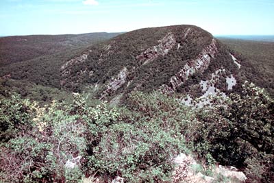
 Mount Tammany 's south face, November 2008 | |
| Highest point | |
| Elevation | 1,527 ft (465 m) |
| Coordinates | 40°58′09″N 75°06′41″W[1] |
| Geography | |
 Mount Tammany Location of Mount Tammany in New Jersey | |
| Location | Delaware Water Gap, Warren County, New Jersey, U.S. |
| Parent range | Kittatinny Mountains |
| Topo map | USGS Portland[1] |
| Climbing | |
| Easiest route | Mount Tammany Trail ascending the western slopes from the Dunnfield Creek trailhead (hike) |
Trails and Hiking
Hiking on Mount Tammany consists of two trails. The red dot trail and the blue dot trail. The red dot trail is 1.2 miles and the blue dot trail is 1.8 miles. Combining the two for one of NJ's most popular hikes is a 3 mile loop. There is a 1201 feet elevation change going up and down the mountain. Generally, this is considered a challenging trail with an average completion time of 2 hours 20 minutes. Climbing up the trail also requires bouldering and physical climbing at some points along the trail. Recommended equipment, comfortable, active footwear, water, appropriate clothing for physical activity. For more information including a detailed analysis of the hike itself, please visit these links below where experienced hikers provide their insight.
https://www.njhiking.com/mt-tammany/ - complete overview and insight on the hike, including photos, tips, and scenic viewpoint locations
https://www.alltrails.com/trail/us/new-jersey/mount-tammany-red-dot-and-blue-dot-loop-trail - trusted source by most experienced hikers for trail conditions and overview.
https://www.nps.gov/dewa/planyourvisit/red-dot-trail.htm - National Parks Service website for up to date closures, alerts, and events for the mountain.
References
- "Mount Tammany". Geographic Names Information System. United States Geological Survey, United States Department of the Interior. 1979-09-08. Retrieved 2009-05-04.
- (Scofield, 38)
- Miles (2020-07-21). "Hiking the Mount Tammany Loop – Red Dot/Blue Dot Trail (2021)". Journeying The Globe. Retrieved 2021-04-03.
External links
Delaware Water Gap National Recreation Area | ||||||||
|---|---|---|---|---|---|---|---|---|
| Points of interest |
|  | ||||||
| History | ||||||||
This Warren County, New Jersey state location article is a stub. You can help Wikipedia by expanding it. |
Другой контент может иметь иную лицензию. Перед использованием материалов сайта WikiSort.org внимательно изучите правила лицензирования конкретных элементов наполнения сайта.
WikiSort.org - проект по пересортировке и дополнению контента Википедии