geo.wikisort.org - Mountains
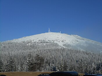
Mount Spokane [elevation 5,887 feet (1,794 m)]—previously known as Mount Baldy until 1912[3] due to its pronounced bald spot—is a mountain in the northwest United States, located northeast of Spokane, Washington. Its summit is the highest point in Spokane County,[2] and it is one of the tallest peaks in the Inland Northwest. Mount Spokane is surrounded by Mount Spokane State Park, Washington's largest at 13,919 acres (56.3 km2). One of the well-known features is a bald spot on the corner of the west and south parts of the mountain.
| Mount Spokane | |
|---|---|
 View from northeast Spokane in 2008 | |
| Highest point | |
| Elevation | 5,887 ft (1,794 m) NAVD 88[1] |
| Prominence | 3,503 ft (1,068 m)[2] |
| Isolation | 53.5 mi |
| Listing | |
| Coordinates | 47°55′25″N 117°06′44″W[1] |
| Geography | |
 Mount Spokane (the United States) | |
| Parent range | Selkirk Mountains |
| Topo map | USGS Mount Spokane |
| Climbing | |
| Easiest route | |

Mount Kit Carson—the second highest peak in Spokane County—is located only 1.02 miles (1.64 km) to the east, and with a topographic prominence of only 322 feet (98 m) could be considered a satellite peak of Mount Spokane.
A non-profit organization operates the Mount Spokane Ski and Snowboard Park, located on the southwest portion of the mountain.
Climate
| Climate data for Mount Spokane, Washington, July 1953 – December 1972 | |||||||||||||
|---|---|---|---|---|---|---|---|---|---|---|---|---|---|
| Month | Jan | Feb | Mar | Apr | May | Jun | Jul | Aug | Sep | Oct | Nov | Dec | Year |
| Record high °F (°C) | 47 (8) |
50 (10) |
54 (12) |
72 (22) |
77 (25) |
83 (28) |
89 (32) |
89 (32) |
81 (27) |
68 (20) |
59 (15) |
46 (8) |
89 (32) |
| Average high °F (°C) | 23.1 (−4.9) |
27.6 (−2.4) |
30.3 (−0.9) |
38.2 (3.4) |
49.0 (9.4) |
57.4 (14.1) |
66.5 (19.2) |
66.0 (18.9) |
56.4 (13.6) |
43.1 (6.2) |
32.5 (0.3) |
26.5 (−3.1) |
43.0 (6.1) |
| Average low °F (°C) | 13.1 (−10.5) |
18.4 (−7.6) |
19.4 (−7.0) |
24.9 (−3.9) |
35.0 (1.7) |
41.1 (5.1) |
49.3 (9.6) |
48.8 (9.3) |
40.9 (4.9) |
30.8 (−0.7) |
22.5 (−5.3) |
16.9 (−8.4) |
30.1 (−1.1) |
| Record low °F (°C) | −23 (−31) |
−17 (−27) |
−20 (−29) |
10 (−12) |
15 (−9) |
21 (−6) |
25 (−4) |
28 (−2) |
18 (−8) |
4 (−16) |
−17 (−27) |
−28 (−33) |
−28 (−33) |
| Average precipitation inches (mm) | 5.83 (148) |
4.61 (117) |
4.94 (125) |
3.49 (89) |
2.78 (71) |
2.71 (69) |
1.30 (33) |
1.54 (39) |
2.75 (70) |
3.71 (94) |
6.24 (158) |
6.25 (159) |
46.15 (1,172) |
| Average snowfall inches (cm) | 39.1 (99) |
20.5 (52) |
25.9 (66) |
10.9 (28) |
5.0 (13) |
0.6 (1.5) |
0.2 (0.51) |
0 (0) |
1.9 (4.8) |
8.1 (21) |
18.2 (46) |
32.2 (82) |
162.5 (413) |
| Source: Western Regional Climate Center[4] | |||||||||||||
Gallery
 View of the summit in 2016
 View from the southwest in 2007
 View from the southwest in the 1920s


References
- "Y". NGS Data Sheet. National Geodetic Survey, National Oceanic and Atmospheric Administration, United States Department of Commerce.
- "Mount Spokane, Washington". Peakbagger.com.
- Rebstock, Tracy. "Mount Spokane". Spokane Historical. Eastern Washington University. Retrieved May 15, 2022.
{{cite web}}: CS1 maint: url-status (link) - "MT SPOKANE SUMMIT, WASHINGTON (455674)". Western Regional Climate Center. 2013. Retrieved on August 26, 2015.
External links
Mount Spokane
- "Mount Spokane". Geographic Names Information System. United States Geological Survey, United States Department of the Interior.
- "Mount Spokane state park". Washington State Parks. Archived from the original on 2011-01-10. Retrieved 2011-01-13.
Protected areas of Washington | |||||||||||||||||||||||||
|---|---|---|---|---|---|---|---|---|---|---|---|---|---|---|---|---|---|---|---|---|---|---|---|---|---|
| Federal |
| ||||||||||||||||||||||||
| State |
| ||||||||||||||||||||||||
| Other |
| ||||||||||||||||||||||||
| |||||||||||||||||||||||||
This Spokane County, Washington state location article is a stub. You can help Wikipedia by expanding it. |
На других языках
[de] Mount Spokane
Der Mount Spokane (5.883 ft (1.793 m)) — bis 1912 unter dem Namen Mount Baldy bekannt[2] — ist ein Berg im Pazifischen Nordwesten der USA, nordöstlich von Spokane im Bundesstaat Washington gelegen. Sein Gipfel ist der höchste Punkt im Spokane County,[3] außerdem ist er einer der höchsten Berge im Binnen-Nordwesten. Der Mount Spokane ist vom Mount Spokane State Park umgeben, dem mit 13.919 Acres (56,3 km²) größten State Park in Washington. Einer der bekanntesten Punkte im Park ist eine kahle Stelle am westlichen und südlichen Hang des Berges. Mount Kit Carson — der zweithöchste Punkt im Spokane County — liegt nur 1,02 mi (1,6 km) östlich, besitzt aber nur eine Schartenhöhe von 322 ft (98 m) und könnte für einen Nebengipfel des Mount Spokane gehalten werden.- [en] Mount Spokane
Другой контент может иметь иную лицензию. Перед использованием материалов сайта WikiSort.org внимательно изучите правила лицензирования конкретных элементов наполнения сайта.
WikiSort.org - проект по пересортировке и дополнению контента Википедии