geo.wikisort.org - Mountains
The Monashee Mountains are a mountain range lying mostly in British Columbia, Canada, extending into the U.S. state of Washington. They stretch 530 km (329 mi) from north to south and 150 km (93 mi) from east to west. They are a sub-range of the Columbia Mountains. The highest summit is Mount Monashee, which reaches 3,274 m (10,741 ft). The name is from the Scottish Gaelic monadh and sìth, meaning "moor" and "peace".[1]
This article includes a list of general references, but it lacks sufficient corresponding inline citations. (April 2010) |
| Monashee Mountains | |
|---|---|
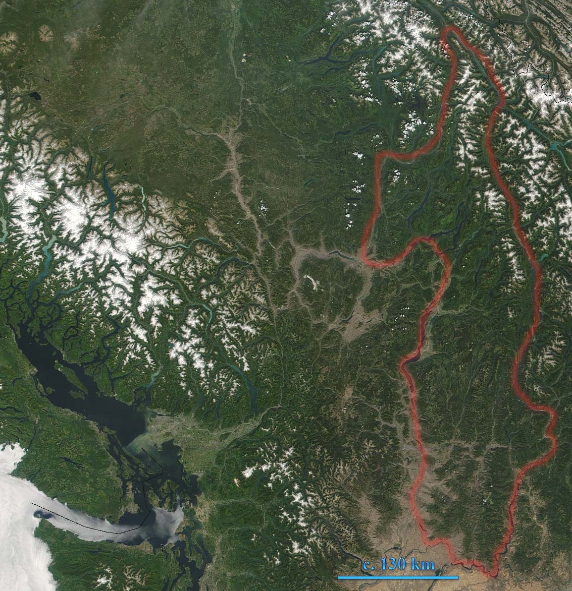 Monashee Mountains are indicated. In the left of the image lies Vancouver Island. The boundary here includes the Okanagan Highland and portions of the Shuswap Highland. | |
| Highest point | |
| Peak | Mount Monashee |
| Elevation | 3,274 m (10,741 ft) |
| Coordinates | 52°23′07″N 118°56′24″W |
| Dimensions | |
| Length | 530 km (330 mi) N-S |
| Width | 150 km (93 mi) W-E |
| Geography | |

| |
| Countries | Canada and United States |
| Provinces/States | British Columbia and Washington |
| Parent range | Columbia Mountains |
Geography

The Monashee Mountains are limited on the east by the Columbia River and Arrow Lakes, beyond which lie the Selkirk Mountains. They are limited on the west by the upper North Thompson River and the Interior Plateau. The northern end of the range is Canoe Mountain at the south end of the Robson Valley, near of the town of Valemount, British Columbia. The southern extremity of the range is in Washington State, where the Kettle River Range reaches the confluence of the Kettle River and the Columbia, and reaches west to the southern extremity of the Okanagan Highland (spelled Okanogan Highland in the US) just northeast of the confluence of the Okanogan and Columbia rivers at Brewster and Bridgeport, Washington.

The Okanagan Highland and parts of the Shuswap Highland to the west of the main range are technically classified as part of the Monashees, however, they may also be considered part of the Interior Plateau. The Okanagan Highland lies between the Kettle River and Okanagan Lake, south of the Shuswap River. Within this area, the small Sawtooth Range lies between the uppermost Shuswap River to the east and Mabel Lake to the west. The portion of the Shuswap Highland south of the North Thompson River to the Okanagan Highland, may also be included. Major peaks include Hallam Peak (3,205 m (10,515 ft)) and Cranberry Mountain (2,872 m (9,423 ft)).
Passes
Between Revelstoke and Shuswap Lake, the range is crossed by Highway 1 - the Trans-Canada Highway - and by the mainline of the Canadian Pacific Railway, which run through Eagle Pass. Highway 6 goes over Monashee Pass. The Crowsnest Highway to the south takes the Bonanza Pass. The southern end of the Monashees within Canada is an historically important mining and former industrial area known as the Boundary Country, which is focused around the basin of the lower Kettle River and extends north toward the Midway Range.[2] The Sherman Pass Scenic Byway runs 40 miles (64 km) east from the town of Republic, Washington across the center of the Kettle River Range and reaches its highest point at Sherman Pass, 5,575 feet (1,699 m), the highest mountain pass open all year in Washington state.[3]
Subranges

Mountains
Source:[4]
- Mount Monashee, 3,274 m (10,741 ft)
- Hallam Peak, 3,205 m (10,515 ft)
- Red Mountain (Rossland), 1,591 m (5,220 ft)
- Mount Lempriere, 3,205 m (10,515 ft)
- Dominion Mountain, 3,131 m (10,272 ft)
- Peak 2892, 2,982 m (9,783 ft)
- Mount Odin, 2,971 m (9,747 ft)
- Gordon Horne Peak, 2,881 m (9,452 ft)
- Cranberry Mountain, 2,872 m (9,423 ft)
- The Pinnacles, 2,607 m (8,553 ft)
- Mount Begbie, 2,733 m (8,967 ft)
- Mount Copeland
- Mount Tilley, 2,649 m (8,691 ft)
- Mount Albreda, 3,052 m (10,013 ft)
Sources
- V., Akrigg, G. P. (1997). British Columbia place names. Akrigg, Helen B. (3rd ed.). Victoria, BC: UBC Press. ISBN 0774806362. OCLC 41086359.
- Fifth Annual Report of the Minister of Mines for the Year Ending 31st December, 1917. Being an Account of Mining Operations for Gold, Coal, Etc., in the Province of British Columbia. The Government of the Province of British Columbia. 1917.
- "America's Byways, Sherman Pass Scenic Byway". Archived from the original on 2007-03-20. Retrieved 2017-12-25.
- Peakbagger.com, Peaks List: Monashee Mountains
- "Monashee Mountains". BC Geographical Names.
External links
На других языках
[de] Monashee Mountains
Die Monashee Mountains sind ein Gebirge in British Columbia, Kanada und Washington, Vereinigte Staaten (78 % der Fläche entfallen auf Kanada, der Rest von 22 % auf die Vereinigten Staaten). Sie erstrecken sich 530 km von Norden nach Süden und 150 km in West-Ost-Richtung und gehören zu den Columbia Mountains. Im Osten schließen sich die Selkirk Mountains an. Das Gebirge wird im Osten durch den Columbia River und die Arrow Lakes begrenzt, westlich liegen der obere North Thompson River, Shuswap Lake und Okanagan Lake. Das nördliche Ende bildet das Robson Valley bei Valemount. Zwischen Revelstoke und Shuswap Lake wird der Gebirgszug vom British Columbia Highway 1, Teil des Trans-Canada Highways und der Hauptstrecke der Canadian Pacific Railway über den Eagle Pass durchquert. Am südlichen Ende der Monashee Mountains herrscht eine rege Bergbauindustrie.- [en] Monashee Mountains
[es] Montañas Monashee
Las montañas Monashee son una cordillera que se encuentra principalmente en la Columbia Británica, Canadá, y que se extiende hasta el estado de Washington en los Estados Unidos. Se extienden 530 km de norte a sur y 150 km de este a oeste. Son una subcadena de las Montañas Columbia. La cumbre más alta es el monte Monashee, que alcanza los 3274 m. El nombre proviene del gaélico escocés monadh y sìth, que significan 'páramo' y 'paz'. [1][fr] Chaîne Monashee
La chaîne Monashee ou montagnes Monashee (en anglais Monashee Mountains[2]) sont un massif montagneux situé dans le sud de la province de Colombie-Britannique au Canada et dans le nord de l'État de Washington aux États-Unis. Ils sont bordés à l'ouest par les montagnes Okanagan et Shuswap et, à l'est, par la Columbia.[it] Monti Monashee
I monti Monashee sono una catena montuosa dell'America settentrionale che si estendono dalla regione sud-orientale della Columbia Britannica in Canada, fino allo Stato di Washington nel nord-ovest degli Stati Uniti d'America.[ru] Монаши (хребет)
Монаши (англ. Monashee Mountains) — горный хребет, расположенный главным образом на юго-востоке канадской провинции Британская Колумбия, а также на северо-востоке штата Вашингтон, США. Является частью горного массива Колумбия. Простирается примерно на 530 км с севера на юг и на 150 км с запада на восток. Восточной границей хребта служит река Колумбия и озёра Арроу, за которыми располагается уже хребет Селкерк. На западе Монаши ограничивает река Томпсон, северной границей является долина Робсон вблизи деревни Валемут. На юг хребет продолжается вплоть до слияния рек Кеттл и Колумбия, а также дальше на юго-запад, в виде горной местности Оканоган вплоть до впадения реки Оканоган в Колумбию.Другой контент может иметь иную лицензию. Перед использованием материалов сайта WikiSort.org внимательно изучите правила лицензирования конкретных элементов наполнения сайта.
WikiSort.org - проект по пересортировке и дополнению контента Википедии