geo.wikisort.org - Mountains
Mount La Perouse is a 10,728-foot (3,270 meter) glaciated mountain summit located in the Fairweather Range of the Saint Elias Mountains, in southeast Alaska, United States. The peak is situated in Glacier Bay National Park, 4 mi (6 km) southeast of Mount Dagelet, 7.6 mi (12 km) south-southeast of Mount Crillon which is the nearest higher peak, and 28.6 mi (46 km) southeast of Mount Fairweather, which is the highest peak in the Fairweather Range. Topographic relief is significant as the mountain rises up from tidewater in less than nine miles. The mountain was named in 1874 by William Healey Dall of the U.S. Geological Survey, for Jean-François de Galaup, comte de Lapérouse (1741-1788), a French navigator who explored this coastal area in 1786.[2][3] The first ascent of the peak was made in 1953 by USGS party consisting of James Seitz, Karl Stauffer, Rowland Tabor, Rolland Reid, and Paul Bowen.[4] On February 16, 2014, a colossal 68 million ton landslide broke free from the flanks of Mt. La Perouse and flowed nearly 4.6 miles (7.4 km) from where it originated.[5] The months May through June offer the most favorable weather for climbing and viewing.
| Mount La Perouse | |
|---|---|
 Mount La Perouse, east aspect | |
| Highest point | |
| Elevation | 10,728 ft (3,270 m)[1] |
| Prominence | 2,778 ft (847 m)[1] |
| Parent peak | Mount Crillon (12,726 ft) |
| Coordinates | 58°33′46″N 137°04′59″W[1] |
| Geography | |
 Mount La Perouse Location of Mount La Perouse in Alaska | |
| Location | Glacier Bay National Park Hoonah-Angoon Alaska, United States |
| Parent range | Fairweather Range Saint Elias Mountains[1] |
| Topo map | USGS Mount Fairweather C-4 |
| Geology | |
| Type of rock | Gabbro |
| Climbing | |
| First ascent | 1953 |
| Easiest route | Mountaineering |
Climate
Based on the Köppen climate classification, Mount La Perouse has a subarctic climate with cold, snowy winters, and mild summers.[6] Temperatures can drop below −20 °C with wind chill factors below −30 °C. This climate supports hanging glaciers on its slopes as well as the immense Brady Glacier to the east, Finger Glacier to the south, and La Perouse Glacier to the north and west. Precipitation runoff and meltwater from its glaciers drains into the Gulf of Alaska.
See also
- Geography of Alaska
References
- "Mount La Perouse, Alaska". Peakbagger.com. Retrieved 2020-01-22.
- "Mount La Perouse". Geographic Names Information System. United States Geological Survey. Retrieved 2020-01-22.
- Mount La Perouse, National Park Service
- American Alpine Journal, Ascent of Mount La Perouse, Publication Year: 1953
- Anchorage Daily News, 68 million ton landslide in Alaska: Mount La Perouse
- Peel, M. C.; Finlayson, B. L.; McMahon, T. A. (2007). "Updated world map of the Köppen−Geiger climate classification". Hydrol. Earth Syst. Sci. 11. ISSN 1027-5606.
Gallery
 Brady Glacier / Mt. La Perouse
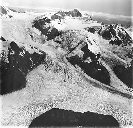 Mt. La Perouse / La Perouse Glacier by Austin Post. 1977
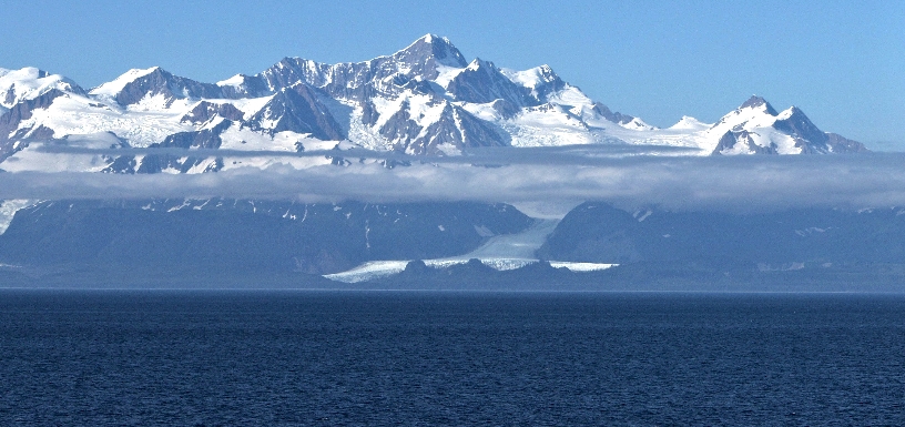 Mount La Perouse with Finger Glacier, from southwest
 Mount La Perouse and Brady Glacier. 1973


External links
- Weather forecast: Mount La Perouse
- Account of first ascent: American Alpine Club
- Aerial photo: Flickr
- Flickr aerial photo: Finger Glacier and Mt. La Perouse
- Flickr photo: 2014 landslide
- Mount La Perouse pronunciation
На других языках
- [en] Mount La Perouse
[fr] Mont La Pérouse (États-Unis)
Le mont La Pérouse (en anglais : Mount La Perouse) est un sommet de la région de recensement de Hoonah-Angoon, dans l'État américain de l'Alaska. Il culmine à 3 270 mètres d'altitude dans le chaînon Fairweather. Il est protégé au sein du parc national de Glacier Bay.Другой контент может иметь иную лицензию. Перед использованием материалов сайта WikiSort.org внимательно изучите правила лицензирования конкретных элементов наполнения сайта.
WikiSort.org - проект по пересортировке и дополнению контента Википедии