geo.wikisort.org - Mountains
Mount Kent is a mountain on East Falkland, Falkland Islands,[1] and is 1,093 ft (333 m) high.[2] It is located north of Mount Challenger.
| Mount Kent | |
|---|---|
 Stone run at Mount Kent | |
| Highest point | |
| Coordinates | 51.6735°S 58.1130°W |
| Geography | |
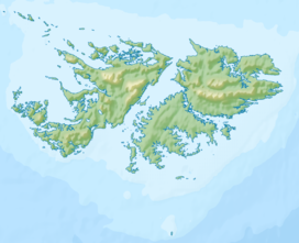 Mount Kent East Falkland, Falkland Islands, south Atlantic Ocean | |
History

The mountain saw action during the Falklands War during the Assault on Mount Kent, part of the larger Battle of Mount Harriet. Some of the location is still mined.
The mountain's top is occupied by the RRH Mount Kent (Remote Radar Head Mount Kent) of the British Forces South Atlantic Islands (BFSAI),[3] part of an early warning and airspace control network including also RRH Mount Alice and RRH Byron Heights on West Falkland.
References
- Strange, Ian (1983) The Falkland Islands
- Mount Kent - Falkland Islands at Peakery.com
- Post Conflict and RAF Stanley. Think Defence Website, 2017
Capital: Port Stanley | |||||||
| History |
| ||||||
| Geography |
| ||||||
| Military |
| ||||||
| Politics |
| ||||||
| Economy |
| ||||||
| Society |
| ||||||
(*) Sixth-formers attend Peter Symonds College in England and national diploma/NVQ students attend Chichester College in England | |||||||
This Falkland Islands location article is a stub. You can help Wikipedia by expanding it. |
Текст в блоке "Читать" взят с сайта "Википедия" и доступен по лицензии Creative Commons Attribution-ShareAlike; в отдельных случаях могут действовать дополнительные условия.
Другой контент может иметь иную лицензию. Перед использованием материалов сайта WikiSort.org внимательно изучите правила лицензирования конкретных элементов наполнения сайта.
Другой контент может иметь иную лицензию. Перед использованием материалов сайта WikiSort.org внимательно изучите правила лицензирования конкретных элементов наполнения сайта.
2019-2026
WikiSort.org - проект по пересортировке и дополнению контента Википедии
WikiSort.org - проект по пересортировке и дополнению контента Википедии