geo.wikisort.org - Mountains
Mont Pelvoux (French: [mɔ̃ pɛlvu]) is a mountain in the Massif des Écrins in the French Alps. It stands 3,946 m (12,946 ft) in elevation.
| Mont Pelvoux | |
|---|---|
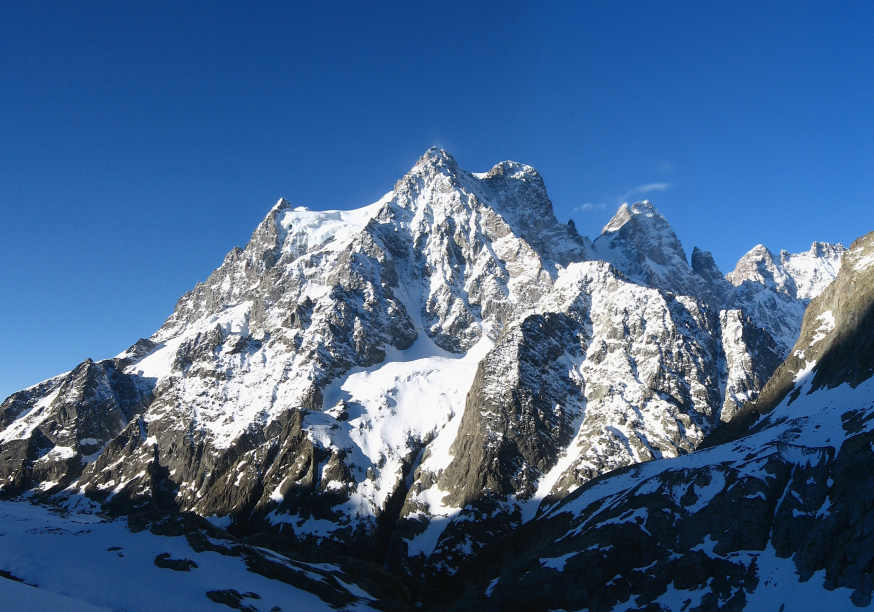 North face of Mont Pelvoux | |
| Highest point | |
| Elevation | 3,946 m (12,946 ft) |
| Prominence | 448 m (1,470 ft)[1] |
| Listing | Alpine mountains above 3000 m |
| Coordinates | 44°53′53″N 6°23′36″E |
| Geography | |
 Mont Pelvoux France | |
| Location | Hautes-Alpes, France |
| Parent range | Dauphiné Alps |
| Climbing | |
| First ascent | Pointe Durand: 30 July 1828 by Captain Durand, A. Liotard and J. E. Matheoud Highest point: 9 August 1848 by P. A. Barnéoud guiding Victor Puiseux |
For many years, Mont Pelvoux was believed to be the tallest mountain in the region, since the taller Barre des Écrins cannot be seen from the Durance valley.
The summit of the mountain is called Pointe Puiseux (French: [pwɛ̃t pɥizø]). There are three subpeaks:
- Pointe Durand (3,932 m (12,900 ft))
- Petit Pelvoux (3,753 m (12,313 ft))
- Trois Dents du Pelvoux (3,682 m (12,080 ft))
Ascents
The first ascent of Mont Pelvoux was by Captain Durand and the two chamois hunters Alexis Liotard and Jacques-Etienne Matheoud on July 30, 1828. This party returned, with more people, to the summit in 1830. Both times they climbed the "Pointe Durand".[2]
The highest point is named after the astronomer Victor Puiseux, who reached it first with his guide Pierre Antoine Barnéoud on August 9, 1848.[3] Barnéoud had been the third guide in the 1830 re-ascent.[2]
See also
- List of mountains of the Alps above 3000 m
References
- "Mont Pelvoux - peakbagger". peakbagger.com. Retrieved 20 March 2015.
- Guillaume Christian, La Première Ascension du Pelvoux en 1828
- W.A.B. Coolidge, Victor Puiseux et la Première Ascension du Mont Pelvoux, The Alpine Journal, Volume 19, 1898
External links
This Provence-Alpes-Côte d'Azur geography article is a stub. You can help Wikipedia by expanding it. |
На других языках
[de] Mont Pelvoux
Der Mont Pelvoux ist ein Berg im Haut-Dauphiné in den französischen Westalpen. Sein Kulminationspunkt ist die 3946 m hohe Pointe Puiseux (Westgipfel). Daneben weist das Massiv mit der Pointe Durand (3.932 m), den Trois Dents du Pelvoux (3.682 m) und dem Petit Pelvoux (3.753 m) drei weitere ausgeprägte Gipfel auf. Zwischen den höchsten Erhebungen eingelagert ist das wenig geneigte Gletscherplateau des Glacier du Pelvoux, dessen Eismassen nach Nordosten im spaltenreichen Glacier des Violettes ou Veyro abfließen. Die höchsten Gipfel sind vom Plateau aus relativ unschwierig zu ersteigen. Das Plateau des Glacier du Pelvoux erreicht man am einfachsten vom Refuge du Pelvoux, einer Schutzhütte des CAF im Süden des Bergstocks, durch die mit Couloir Coolidge bezeichnete, 35° steile Eis- und Firnrinne, die selbst Teil des Glacier de Sialouze ist (Schwierigkeitsgrad »peu difficile« auf der französischen Bewertungsskala, ca. 4 Stunden ab der Hütte).- [en] Mont Pelvoux
[es] Monte Pelvoux
El Monte Pelvoux es una montaña del Macizo des Écrins en los Alpes franceses. Tiene una altitud de 3.946 m.[1][2][fr] Mont Pelvoux
Le mont Pelvoux est un sommet français faisant partie du massif des Écrins, dans les Hautes-Alpes.[it] Monte Pelvoux
Il monte Pelvoux è una montagna del massiccio des Écrins, nelle Alpi del Delfinato. Si trova nel dipartimento delle Alte Alpi, nel comune di Pelvoux.Другой контент может иметь иную лицензию. Перед использованием материалов сайта WikiSort.org внимательно изучите правила лицензирования конкретных элементов наполнения сайта.
WikiSort.org - проект по пересортировке и дополнению контента Википедии